Multiple terms: term1 term2
red apples
returns results with all terms like:
Fructose levels in red and green apples
Precise match in quotes: "term1 term2"
"red apples"
returns results matching exactly like:
Anthocyanin biosynthesis in red apples
Exclude a term with -: term1 -term2
apples -red
returns results containing apples but not red:
Malic acid in green apples
hits for "" in
Network problems
Server timeout
Invalid search term
Too many requests
Empty search term
MITM10
Introduction
The European Space Agency’s Planetary Science Archive (PSA, https://psa.esa.int) is a multi-mission system curating, preserving and serving the data of ESA’s planetary mission. All data are stored in the Planetary Data System (PDS) format and can be searched and retrieved through a unified user interface and APIs. Here we report on the latest updates to PSA functionality and the plans for the coming releases.
Recent updates
A lot of effort in recent months has been invested in preparing for the migration of legacy PDS3 data from Venus Express, Chardrayaan-1, Giotto and SMART-1 to PDS4 format. The data have been converted by adopting the current PDS4 conventions used in PSA, for example migrating all the raw datasets into a single raw data collection. As a part of this process the dataset and product names have changed. The PSA has been updated to allow search for both the old and new identifiers. Documentation is being prepared to explain to users of the new data how the PDS3 keywords described in the PI-team provided documents are mapped to PDS4. The original PDS3 legacy datasets will be maintained on the PSA FTP.
PSA separates data into two categories – primary observational data, and ancillary data to support this (browse images, calibration and geometry data etc.). Previously, API access to these data required knowing which category a product belonged to. A simplified API has now been released which allowed data to be retrieved by LID or LIDVID, regardless of its type.
A long-awaited feature released in PSA 7.9.0 is the ability to share or bookmark a permalink which restores almost all facets of a PSA search. This means that users can share a URL which encodes the current view and all filters, including for example the instrument, time range, map view region of interest etc.
On the user interface front, both the map and gallery views have received updates. The map view is now more performant for multi-mission and multi-instrument searches, displaying the results for each instrument in a separate GIS layer, whilst the gallery view supports “infinite scroll”, pre-loading (and down-sampling) images as the user moves down the page.
Finally, a new download mechanism has been introduced. Instead of packaging data into a zip or similar this provides the user a python or bash script which requests files individually from the archive. This allows for download of much larger data volumes without the delays associated with compressing the file.
Future plans
User interface improvements are a major goal for the next few PSA releases. Further refinements are planned to the map view, improving the way users perform initial searches by using coarse product counts to prompt the user to refine their search until a sensible number of footprints are displayed. A number of small usability enhancements are also planned (e.g. shift-click for range select in both the table and gallery views).
The PSA has re-started work this year on the Rosalind Franklin Mission (RFM) archive. As well as the standard ingestion and retrieval functions, dedicated views will be provided to show the rover traverse over the Martian surface, allowing users to find images and sample analyses along the route. With the arrival of BepiColombo at Mercury, a flood of data are expected, populating the Mercury map view and preparing for the first Mercury orbit data release next year. Finally, PSA will start supporting archiving of laboratory data of relevance to planetary science, in the context of Mars analogue samples.
As always, user feedback is critical to the continued development of the PSA and the science community is invited to let us know what does and (more importantly) doesn’t work for you!
How to cite: Bentley, M., D’Angelo, N., Breitfellner, M., Coia, D., Cornet, T., Cuevas, A., Docasal, R., Grotheer, E., Heather, D., Guerrero, F., Lara, I., Lim, T., Mahlke, M., Maia, J., Oliveira, J., Osinde, J., Raga, F., and Ramos, G.: ESA’s Planetary Science Archive: what’s new, and what’s to come, Europlanet Science Congress 2026, The Hague, The Netherlands, 7–11 Sep 2026, EPSC2026-325, https://doi.org/10.5194/epsc2026-325, 2026.
Orbital dynamics analyses are crucial for a wide range of solar-system science investigations, including spacecraft radio-science data analysis for planetary geodesy and small-body orbit estimation and prediction applications in both solar-system evolution and planetary defense. Yet, many of the software systems and data-analysis pipelines used for orbit propagation and orbit estimation are closed-source, application-specific, or difficult to reproduce outside the originating team. This limits independent validation, reuse of previous analyses, systematic combination of heterogeneous data types, and broader community participation.
Here, we present our project to set up the General Open Orbital Dynamics (GOOD) platform, an open-science infrastructure that will combine the TU Delft Astrodynamics Toolbox (Tudat) [1,2] with the University of Groningen’s WISE-based data-handling technology [3]. The platform is funded by OpenScienceNL, a Dutch national programme supporting the transition to open science through targeted funding, policy development, and community building; its initial development phase will run until late 2029.
Tudat provides open-source high-fidelity numerical propagation and estimation capabilities for spacecraft and natural solar-system bodies. WISE provides scalable astronomical data handling, with detailed data lineage and reproducible processing workflows. By integrating these two systems, GOOD will provide an open platform on which researchers, data providers, and citizen-science contributors can run, validate, archive, retrieve, and update orbit-dynamics analyses together with their input data, configuration files, software versions, and output products. The resulting platform is intended to function not only as a repository for data products, but as an executable and traceable analysis environment in which complete orbit-dynamics workflows can be rerun, inspected, modified, and extended, with full access to all associated data and source code.
Tudat is already used by a growing research community for planetary mission analysis, natural-body ephemeris estimation, and space situational awareness. However, transparently and consistently sharing complete analysis setups, input data, processing histories, and resulting products remains difficult in practice. WISE directly provides this missing layer through its data-centric architecture for scalable data handling, provenance tracking, and reproducible workflows, making the integration of Tudat and WISE a core aspect of realizing the GOOD platform. This will establish a framework through which previous analyses become more accessible to the community, while new analyses become easier to configure, validate, and reproduce.
Our vision is to have a platform where the full analysis setup, including all data, scripts and files needed to reproduce a published analysis, is retrievable by a single web-based request or terminal command. The platform will be seeded by the proposal team and their scientific networks, using the numerous analyses currently ongoing (see for instance [4][5][6][7][8] in these proceedings). Each analysis will be packaged with its input data, model settings, processing history, and results, and will be assigned persistent identifiers where appropriate. By archiving analyses performed using the platform within a consistent configuration framework, GOOD will allow users to continue from previous work rather than reconstructing complete processing chains from publications, local scripts, or undocumented assumptions.
Beyond making existing analyses available, the data-lineage functionality of the WISE-based technology will support automatic updates of archived analyses when additional tracking data or new calibration products become available. This will help keep archived analyses traceable and up to date as improved inputs are released. The platform will also support automatic generation of skeleton configurations for new analyses, based on user-provided targets, data types, dynamical models, and desired accuracy. This will facilitate the process of setting up analyses of new targets or datasets by limiting the effort required from the researcher/user to those aspects that are very specific to their application, while generic steps such as data retrieval, pre-processing, configuration validation, and workflow execution are automated where possible. Finally, while the platform will primarily use existing data sources such as PDS, PSA, MPC, as well as astrometric data from Gaia and Euclid, it will also provide the option for users to upload their own data, for both their own analyses and reuse by others
The scope of the project includes the processing and modelling of spacecraft radio-tracking data (see [9] in these proceedings for specific developments made for our platform), optical Earth- and space-based astrometry, stellar occultations and radar ranging. Example applications include the analysis of planetary mission tracking data, improved ephemerides of natural satellites, asteroid orbit determination and prediction, and automated orbit estimation of Earth-orbiting objects/debris for Space Situational Awareness. Given the broad scope of the project, we will also cover applications on the interface of typical analysis regimes, such as the orbit determination of cislunar space debris. The same infrastructure will also support adjacent applications in space situational awareness and near-Earth-object monitoring, where reproducible estimation and uncertainty quantification are similarly critical.
A central aim of GOOD is not to replace existing tools or databases, but to make orbit-dynamics analyses more transparent, interoperable, and reusable. The platform will adopt existing standards where available, provide translation layers to external tools and data formats where possible, and define open interfaces for community contribution. It will be accessible through both web-based and terminal-based interfaces, with documentation, tutorials, issue tracking, and training material developed alongside the technical infrastructure.
At EPSC, we will present the scientific motivation, preliminary results, planned architecture, initial use cases, and development roadmap for GOOD. We will also seek input from the planetary-science community on priority datasets, model requirements, configuration standards, and potential contributed use cases. The long-term goal is to make orbit propagation, orbit estimation, and associated planetary-science data products open, reproducible, and reusable by design.
[1] Dirkx, D., et al. (2022), EPSC2022-253
[2] Gisolfi, L, et al. (2025), arXiv preprint arXiv:2510.23179
[3] Begeman et al. (2013), Exp Astron 35,1–23
[4] Hener, J., et al. (2026), (these proceedings)
[5] Reichel, M., et al. (2026), (these proceedings)
[6] Rodriguez Sanchez, A., et al. (2026), (these proceedings)
[7] Revellino M. M. et al. (2026), (these proceedings)
[8] Attree N. et al. (2026), (these proceedings)
[9] Hinüber. et al. (2026), (these proceedings)
How to cite: Dirkx, D., Verdoes Kleijn, G., Balbinot, E., Fayolle, S., Gehly, S., Gisolfi, L., Hinüber, L., Kok, M., Langbroek, M., and Quintero, Y. and the The General Open Orbital Dynamics Platform: The General Open Orbital Dynamics (GOOD) Platform: Open-Source and Reproducible Orbit Propagation and Parameter Estimation for Solar-System Science, Europlanet Science Congress 2026, The Hague, The Netherlands, 7–11 Sep 2026, EPSC2026-279, https://doi.org/10.5194/epsc2026-279, 2026.
The astronomy, heliophysics and planetary science communities are advanced communites for open science and the application of the FAIR principle. With the OSTrails project, we propose to go a step further. OSTrails is organized around three pillars:
- Plan: adoption of a machine actionable Data Management Plan tool to streamline the data life cycle management
- Track: merging existing knowlegde graphs and research product registries to enable new data discovery and impact tracking pathways
- Assess: definition of what FAIR means for astronomy and its sub-communities.
We will also show how to build on previous work (e.g., FAIR-IMPACT) and current developments (like https://ontoportal-astro.eu, developed through the OPAL project). We present how these three pillars are great enhancing the FAIR principles of these communites, with better data management, improved findability and FAIR assessment.
This work is supported by the OSTRAILS project, which received funding from the European Union's Horizon Europe framework programme under grant agreement No 101130187. It is also supported by OPAL, a cascading grant of the OSCARS project, which received funding from the European Union's Horizon Europe framework programme under grant agreement No 101129751.
How to cite: Cecconi, B., Le Sidaner, P., Fretel, L., and David, E.: Upgrading FAIR in astronomy with OSTRAILS and OPAL, Europlanet Science Congress 2026, The Hague, The Netherlands, 7–11 Sep 2026, EPSC2026-1064, https://doi.org/10.5194/epsc2026-1064, 2026.
Language models are powerful tools for processing linguistic data, i.e., unstructured data. In recent years, interest in language models within astrophysics has grown rapidly, driven by the increasing number of scientific publications and the expansion of astronomical terminology. A key objective is to create an environment that facilitates knowledge accessibility, often involving the alignment of data with controlled vocabularies to enable efficient search.
However, only a limited number of publications comply with existing standards, and not all semantic artifacts are interoperable. As a result, they require a standardization process, which can be tedious to perform manually on large datasets. The NASA Astrophysics Data System is engaged in such efforts across multiple areas.
This need to process unstructured data in astronomy, combined with recent breakthroughs in artificial intelligence driven by the emergence of large language models, has led to the development of domain-specific models. These include fine-tuned BERT-based models such as AstroBERT (2022), AstroLLaMA (2023), and Pathfinder (2024). Most of these models are trained to predict the next token in large corpora of astronomical literature, allowing them to acquire domain-specific knowledge and function as powerful scientific assistants.
At Paris Observatory, we worked on two projects involving unstructured data: the alignment of observation facilities across multiple semantic artifacts, and the assignment of UAT keywords to uncategorized papers.
We leveraged a range of natural language processing techniques and language models, in both supervised and unsupervised settings, to perform various tasks. These include LLM-based decision-making and label or definition generation through prompting; transformer-based models and TF-IDF vectorization for ranking-based recommendation systems, such as entity alignment and keyword recommendation; and linear regression and graph neural networks for classification.
We discuss the advantages and limitations of these methods and illustrate them through two case studies.
How to cite: Fretel, L., Cecconi, B., and Louis, C.: Language Models and Natural Language Processing applications in Astronomy: two Case Studies, Europlanet Science Congress 2026, The Hague, The Netherlands, 7–11 Sep 2026, EPSC2026-1219, https://doi.org/10.5194/epsc2026-1219, 2026.
Introduction
The SSHADE database infrastructure (http://www.sshade.eu), initially developed within the Europlanet-2020 and 2024 RI programs, contains two main types of data. First, it hosts the databases of about 30 experimental research groups from 15 countries working on spectroscopy of solids. This large set of databases currently provides over 9,200 spectra of many different types of solids (ices, minerals/rocks, carbonaceous matters, meteorites, …) over a very wide range of wavelengths (mostly X-ray and VUV to sub-mm). One of the main advantages of SSHADE is to provide a comprehensive set of metadata on the sample and the spectral measurement.
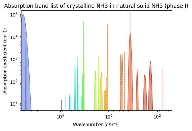
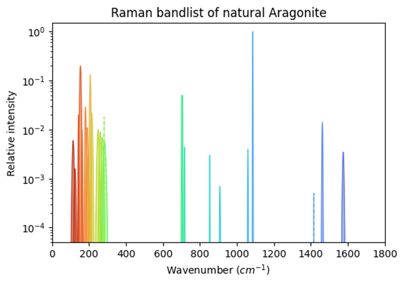
The second spectral product offered by SSHADE is its world-unique ‘band list database’ providing lists of UV-Vis-IR absorption bands and Raman emission bands of molecular solids and minerals of astrophysical, planetary and geoscience interest.
SSHADE has already a large and fast-growing user’s community with over 1,100 registered researchers (350+ new users expected in 2026).
SSHADE band lists
The band list database contains the characteristics (band position, width, intensities, isotopic species involved, mode assignment, …) of electronic, molecular vibration and crystal phonon bands of molecular solids (ices, simple organics) and minerals in various phases (crystalline, amorphous, ...) at different temperatures or pressures. It includes two sub-databases, one for UV-Vis-IR absorption spectroscopy and the second for Raman emission spectroscopy.
We are feeding this database through exhaustive compilations and critical reviews of all spectral data published in various journals and in SSHADE itself, on molecular solids and their simple compounds (binary solid solutions, hydrates, clathrates, ...) as well as on fundamental minerals.
Over the last years we published the absorption band lists of 23 ices and two minerals as well as the Raman band lists of 33 minerals, mostly carbonates, and 10 ices.

Figure 1: Absorption bandlist of crystalline NH3 (phase I).

Figure 2: Raman bandlist of Aragonite.
An efficient search tool allows you to search either a band list or a specific band thanks to a set of filters on various parameters, such as band position, width and intensity, expected molecular or atomic composition. The selected band list can be displayed graphically and the data can be exported as a table containing the main parameters of all the bands of the band list, as well as detailed metadata. A data reference and a DOI are associated with each band list.
SSHADE-Band list is now also a service of the VESPA Virtual Planetary Observatory. It is accessible via the EPN-TAP protocol, which allow comparison with observational data and mass processing in the VESPA environment or in other services.
Spectral tools
In order to allow the SSHADE users to compare their own astronomical or laboratory spectra with data provided in our databases, we developed a series of tools to import and store user spectra, plot them together with SSHADE data and apply various conversion operations to the spectra.
- The user’s data import tool
It allows a registered user to import and manage its own spectra (in ascii/csv format) in SSHADE before comparing them with SSHADE spectra or band lists. After comparison, the user can keep it in its protected private space in SSHADE or delete it.
Comparison and data conversion tools: The Comparator Tool
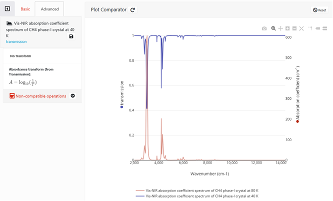
- Compare spectra across datasets: This tool allows to dynamically plot spectra from different experiments, from various solids, instruments or experimental conditions across the databases hosted by SSHADE. It is also possible to compare them with band lists.
- Convert spectra
A number of conversion and calculation options have been recently developed for transmission, absorbance, absorption coefficient and optical constants spectra. This tool, which will soon be available publicly on SSHADE, allows to determine absorption coefficient from absorbance, knowing the thickness of the sample, to convert absorption coefficients to imaginary indices, and inversely. It also allows to calculate absorbance from transmission spectra and derive absorption coefficients. Reversely, it can simulate the transmission spectrum of a sample of known thickness from either absorption coefficients or optical constants.

Figure: Comparison and calculation tool of SSHADE and user spectra.
- Export
The converted spectra can be stored in the user personal space and exported using the SSHADE export customization tool.
- Ongoing and future developments
We are working to enrich the ‘Comparator Tool’ with more advanced tools for spectroscopists, including a ‘convolution tool’ that will allow to perform a spectral convolution of the SSHADE laboratory spectra at the specific resolution and sampling of a series of past, current and future space instruments.
Acknowledgements
We acknowledge support from OSUG for its financial and manpower supports, CNES for its financial support through the SBDSC program. The Europlanet 2024 Research Infrastructure project received funding from the European Union's Horizon 2020 research and innovation programme under grant agreement No 871149.
References
- Schmitt, B., et al. (2018) SSHADE: "Solid Spectroscopy Hosting Architecture of Databases and Expertise" and its databases. OSUG Data Center. Service/Database Infrastructure. doi:26302/SSHADE
How to cite: Schmitt, B., Albert, D., Dode, E., Mandon, L., Bonal, L., and Dionnet, Z.: The SSHADE database infrastructure for Solid Spectroscopy: Evolutions 2023-2026 , Europlanet Science Congress 2026, The Hague, The Netherlands, 7–11 Sep 2026, EPSC2026-541, https://doi.org/10.5194/epsc2026-541, 2026.
The study of extraterrestrial samples returned to Earth by space missions or as meteorites is an integral part of research in the planetary sciences. Chemical, physical, and textural properties of these samples provide fundamental insights into the history of the Solar System and natural processes beyond Earth. With an increasing number of global planetary missions and new opportunities in data analytics, there is an urgent need to agree on consistent practices and technical standards for digitally curating returned samples and disseminating and archiving the data generated by laboratory analysis of the samples. Such practices and standards should to the degree possible align with existing data standards for planetary data as well as for scientific samples across domains and with best practices for laboratory analytical data of geoscience samples.
The Astromaterials Data System (Astromat, https://www.astromat.org) is the primary NASA-sponsored data archive for laboratory analyses of returned samples from planetary missions (e.g., Apollo, OSIRIS-REx) and for meteorites. Astromat has been working with various international organizations, programs, and initiatives to establish data, metadata, and curation standards, best practices, and policies that optimize findability and reusability of the data hosted and archived at Astromat. Ongoing activities that we will report on include the implementation of the IGSN as a persistent identifier for samples in collaboration with the IGSN e.V. and DataCite; the development of TAPPs (Technique-aligned Protocol Profiles) jointly with the OneGeochemistry initiative and based on the OSIRIS-REx Sample Analysis Data Standard Documents; and collaboration with the Planetary Data System to develop PDS4-compliant Data Dictionaries for sample data. Laboratory analytical data for astromaterials samples are also integrated into a database that aggregates and harmonizes compositional data and provides APIs for machine-actionable access to large volumes of analytical data that have so far been highly fragmented and difficult to use in computational methodologies.
How to cite: Lehnert, K., Deng, R., Richard, S., Mays, J., Ji, P., and Danninger, G.: FAIR and Science-Ready Data of Returned Samples, Europlanet Science Congress 2026, The Hague, The Netherlands, 7–11 Sep 2026, EPSC2026-1212, https://doi.org/10.5194/epsc2026-1212, 2026.
VESPA is an environment designed to facilitate both the sharing and access of data relevant to Solar System science. It has been developed within the framework of the Europlanet 2020 and Europlanet 2024 Research Infrastructure programmes. Building on the infrastructure of the astronomical Virtual Observatory (VO), VESPA extends VO standards and tools to support planetary science and heliophysics data [1]. Central to this framework is EPN-TAP [2], a standardized metadata vocabulary and access protocol that enables a uniform description of Solar System datasets and efficient discovery across large, distributed repositories. EPN-TAP is regularly extended to support an increasing range of applications, including observational data, numerical simulations, and laboratory measurements.
Current status: As part of the Virtual Observatory ecosystem, VESPA strongly promotes Open Science and FAIR principles in order to facilitate interoperability and reuse of planetary science data. The infrastructure currently provides access to 96 certified data services together with more than 70 planetary HiPS datasets (multi-resolution maps). These services are contributed by over 30 institutes worldwide and include the ESA Planetary Science Archive, collections from the PDS PPI node, results from more than ten European research programmes, derived products from over twelve space-borne instruments, as well as datasets produced by several Pro-Am collaborations. Certified services can be queried simultaneously through the VESPA portal, enabling homogeneous discovery across distributed repositories. In total, nearly 250 EPN-TAP services of various sizes are currently declared in the IVOA registry, many of which are in the process of validation and integration into the operational VESPA environment.
Activities in progress: Current VESPA activities focus on two complementary objectives: extending the accessible data content and improving scientific workflows based on interoperable services.
A major effort is devoted to enlarging the range of accessible datasets. Regular interactions with space agencies support the deployment of EPN-TAP interfaces on existing archives, while dedicated solutions are being developed to expose planetary science datasets embedded in astronomical observatory archives. At the same time, lightweight and well-documented procedures are being promoted to enable small research teams to share original datasets and derived products, typically associated with scientific publications or research projects. These activities also support Pro-Am collaborations and citizen science initiatives, including stellar occultation observations [3] and fireball network data.
In parallel, VESPA identifies and develops use cases corresponding to common research tasks in planetary science. A key capability is the possibility to submit a single query simultaneously to distributed data services worldwide and to cross-match the returned results. To support such workflows, new functionalities are progressively implemented in existing Virtual Observatory tools, enabling faster data discovery, visualization, and analysis across heterogeneous planetary science datasets. Uses cases are available here: https://github.com/epn-vespa/tutorials/tree/master
Developments: VESPA has consistently focused on data content, interoperability procedures, and the adaptation of existing Virtual Observatory standards to planetary science needs. In this context, dedicated software developments have deliberately been kept to a limited scope in order to maximize sustainability and efficiency while relying as much as possible on the broader VO ecosystem.
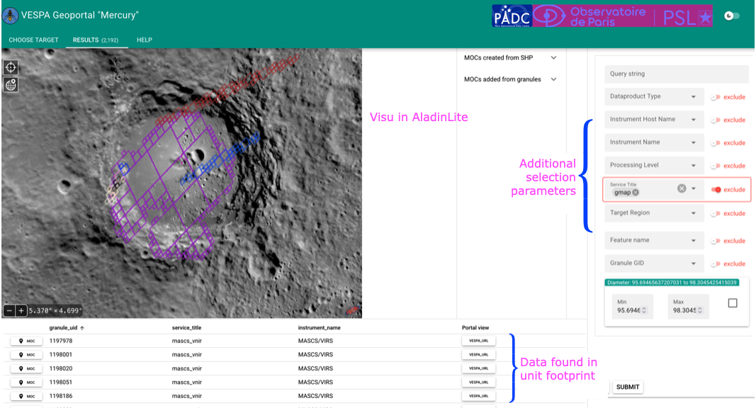
The only tools specifically developed within VESPA are the main portal, which enables simultaneous querying of all validated services, and the VESPA geoportal, a VO-based GIS environment supporting EPN-TAP datasets georeferenced on planetary surfaces together with external footprints. In several cases, SAMP interfaces have also been implemented in external applications to facilitate seamless data exchange.
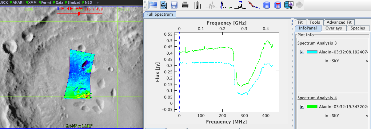
Most new functionalities required by the planetary science community have instead been integrated directly into existing VO tools by their original developers, particularly in Aladin, Aladin Lite, TOPCAT, and CASSIS. Similarly, developments related to scripted workflows have largely relied on community Python libraries such as astropy and pyvo, with extensions focused on planetary science use cases.

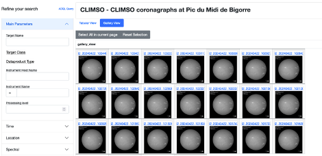
Fig.1: Solar images from CLIMSO in the VESPA portal in gallery mode

Fig.2: A CRISM spectral cube overplotted on the CTX HiPS in Aladin. Spectra are displayed with the CASSIS plugin

Fig.3: MESSENGER data in the VESPA geoportal. Data is found inside shapefile footprints from a publication
Prospects: VESPA continues as an active partner of the Europlanet community beyond its funded programmes, and contributes to international consortia in this field: IVOA [International Virtual Observatory Alliance], IPDA [International Planetary Data Alliance] and IHDEA [International Heliophysics Data Environment Alliance]. The main focus in the coming years will cover semantics, mapping to other metadata vocabularies, and ML readiness.
VESPA also participates to various European programmes in Astronomy and Open Science [4] and is involved in several projects of data infrastructures at national level, e.g. [5]. VESPA is committed to participating in future European science activities and to contributing to building an EOSC node for astronomy.
The Europlanet-2024 Research Infrastructure project has received funding from the European Union's Horizon 2020 research and innovation programme under grant agreements No 871149.
[1] S. Erard, B. Cecconi, P. Le Sidaner, M. Demleitner, and M. Taylor, “EPN-TAP: the VO standard to share and access Solar System data” PV2023 conference, Dec. 2023, doi: 10.5281/ZENODO.10255587
[2] S. Erard, B. Cecconi, P. Le Sidaner, M. Demleitner, and M. Taylor, “EPN-TAP: Publishing Solar System Data to the Virtual Observatory Version 2.0” IVOA Recommendation 22 August 2022. https://ivoa.net/documents/EPNTAP/
[3] T. Chope et al. “Towards a Community Standard for Stellar Occultation Results: an EPN-TAP Extension and Prototype Service”. 15th ACM conference, June 2026, Poznań, Pol.
[4] M. Molinaro et al. “Astronomy Open Science Competence Centre in Europe”. ADASS XXXV, Nov. 2025.
[5] F. Schmidt et al “Planetary Data Surface: Services and Portals (PDSSP)” This conference.
How to cite: Erard, S., Cecconi, B., Le Sidaner, P., Chauvin, C., Haigron, R., Fernique, P., Boch, T., Demleitner, M., and Taylor, M.: Virtual European Solar & Planetary Access (VESPA) 2026: Perseverance, Europlanet Science Congress 2026, The Hague, The Netherlands, 7–11 Sep 2026, EPSC2026-1012, https://doi.org/10.5194/epsc2026-1012, 2026.
Please decide on your access
Please use the buttons below to download the supplementary material or to visit the external website where the presentation is linked. Regarding the external link, please note that Copernicus Meetings cannot accept any liability for the content and the website you will visit.
Forward to presentation link
You are going to open an external link to the presentation as indicated by the authors. Copernicus Meetings cannot accept any liability for the content and the website you will visit.
We are sorry, but presentations are only available for conference attendees. Please register for the conference first. Thank you.
The Planetary Data Surface : Services and Portals (PDSSP) is a geospatial data and services center dedicated to studies and research on planetary surfaces. The aim of the PDSSP is to facilitate access to data and contribute to the creation of products and services by adding value to existing space data .The facility will also serve as a mechanism for the planetary science community to share information and better address the challenges of digital technology. It will be part of the national, European and global landscape, working closely with PSUP (Planetary Surface Portal), VESPA (Virtual European Solar and Planetary Access) and SSHADE (Solid Spectroscopy Hosting Architecture of Databases and Expertise) services.
The PDSSP offers a search portal to help disseminate and use high value-added data for planetary surfaces. This includes spectral data, geological maps, high-resolution images and DEMs and other useful information for the scientific community, students and general public interested in planetary studies.
The PDSSP also contributes to collaboration and interoperability between different thematic projects in the field of planetary surfaces, by providing tools, services and expertise to facilitate information exchange and collaboration between scientists and researchers.
The PDSSP's mission is to bring together existing facilities to serve the planetary science community. It is based on the establishment of a spatial data infrastructure for planetary surfaces, providing access to its data. It aims at providing added value, particularly in terms of data and services in fields where data centers do not exist or need to be developed, and in terms of links with European and international systems. The aim is to strengthen the planetary science community, in synergy with the other structures in the field, by giving it access to the data it needs for its research, in accordance with the access standards.
The STAC-PLANET project is the flagship initiative of the PDSSP in this first phase. It is based on the adaptation of terrestrial standards from the Open Geospatial Consortium (OGC) to planetary surfaces, providing unified access to planetary data. STAC-PLANET is currently under development at CNES as a contribution to the PDSSP project, and its first version is expected to be released by the end of 2026.
Another tool of interest in this context is the VESPA geospatial portal (https://padc-findme.obspm.fr). This environment is essentially a GIS based on Virtual Observatory procols and standards, which connects georeferenced data collections accessible through the EPN-TAP protocol. The tool allows quick identification of observing configurations, overlaps and superpositions between data products from various collections, including external footprints.
STAC-PLANET takes a complementary approach, offering a GIS fully compatible with Earth Observation tools and standards, while adding VO services that translate Earth Observation protocols into VO-compliant interfaces, making planetary data accessible to both communities within a single integrated framework.
PDSSP: pdssp.eu (coming soon)
PSUP : http://psup.ias.u-psud.fr/
SSHADE : https://www.sshade.eu/
VESPA : https://vespa.obspm.fr
How to cite: Schmidt, F., Malapert, J.-C., Boomi, S., Guillemot, P., Seignovert, B., Andrieu, F., Volat, M., Erard, S., Quantin-Nataf, C., Bultel, B., Ballans, H., Maurin, L., Lantz, C., Le Sidaner, P., Douté, S., Schmitt, B., Bonal, L., Mandon, L., Conway, S., and Le Mouélic, S.: Planetary Data Surface : Services and Portals (PDSSP), Europlanet Science Congress 2026, The Hague, The Netherlands, 7–11 Sep 2026, EPSC2026-78, https://doi.org/10.5194/epsc2026-78, 2026.
Radiometric observations taken of a spacecraft allow for the precise reconstruction of its trajectory through the process of orbit determination. Besides the use in spacecraft navigation, this also allows for the estimation of related parameters such as ephemerides of natural objects, geophysical parameters, or fundamental physical quantities. Current state-of-the-art software for processing radiometric observations is typically closed source and not publicly available, which hinders the independent analysis, verification and interpretation of results. With new and upcoming missions providing more data in planetary systems that have been studied in previous missions, fusing information from multiple missions is becoming increasingly important, and will provide valuable insights in the evolution of planetary systems and constraints over longer timescales. To achieve this, a consistent and transparent combination of these different data sources is crucial to prevent unresolved biases or processing artifacts from affecting the solution. In this work we present the capabilities of the open-source TU Delft Astrodynamics Toolbox (Tudat) [1, 2] for processing and simulating radiometric observations from multiple missions and heterogeneous file formats, which forms the foundation for the integration of radiometric observations in the General Open Orbital Dynamics (GOOD) platform [3]. Applications of this framework to orbit estimation problems are currently underway (see [4, 5, 6]) and will be expanded in the future.
Various formats exist to store radiometric observations, including binary file formats, such as the ODF format (TRK 2-18), ATDF format (TRK 2-25), and TNF format (TRK 2-34), and plain text formats such as the IFMS format, and CCSDS TDM format. Currently, Tudat has readily available file readers for ODF files, TNF files (based on NASA Planetary Data System Software [7]) and IFMS files. Additionally, a generic text-file interface is available, allowing to ingest files based on a tabulated user-specified format, such as files containing processed radiometric range data used in planetary ephemerides [8]. To use the observations in orbit determination and parameter estimation, corresponding observation models are required that simulate the observable based on the current set of parameters. At present, Tudat has observation models implemented for two- and three-way sequential range and Doppler observations. Correction models for the observables can be specified by the user depending on the needs of their application. Available models include first- and second-order relativistic corrections [9], tropospheric corrections (ranging from simple models such as based on Estefan et al. [10] to high-fidelity approaches using the VMF3 model [11]), ionospheric corrections (ranging from tabulated models provided by the DSN [9] to high-fidelity models that use VTEC maps from IONEX files [12]) and charged particle corrections due to the Solar corona (using the model outlined in Verma et al. [13]).
Building upon previous work [2], we present the recently extended capabilities and future plans of Tudat in the processing and simulation of radiometric observations, with a focus on the unified processing, conversion to internal representations, and consistent application of user-defined observation corrections. Using pre-fit residuals (i.e., observations computed on the spacecraft reference trajectory, compared to the actual observed values) we validate recent developments to produce state-of-the-art results, and discuss future improvements. Previous and ongoing analyses with Tudat using data from NASA’s GRAIL, MRO and Cassini missions, and ESA Mars Express and Rosetta missions found the root mean square (RMS) of the two- and three-way Doppler pre-fit residuals in the order of several mHz at an integration time of 60 s. The sequential range pre-fits of MRO have an RMS of several meters, while retaining a small systematic trend [2]. Planned developments include the processing of ATDF files (using the tool by Verma [14]) and CCSDS TDM files, implementation of a one-way Doppler observation model, and implementation of tropospheric corrections based on Advanced Water Vapor Radiometer measurements. Combined with the capability of Tudat to process astrometric measurements in the same analysis (see [15, 16]), this lays the foundation for reproducible research in astrodynamics and planetary science. The Tudat development and core user team is committed to open science, by developing the tools fully open source, and disseminating full analysis scripts and data sets after publication. This will allow the community to reproduce, extend, and combine existing radiometric tracking-data analyses, to tackle challenges in data fusion and consistent data weighing of multi-mission, multi-datatype analyses in a transparent manner.
References
[1] Dirkx et al. EPSC. 2022.
[2] Gisolfi et al. IAC. 2025.
[3] Dirkx et al. EPSC. 2026.
[4] Hener et al. EPSC. 2026.
[5] Reichel et al. EPSC. 2026.
[6] Sánchez Rodríguez et al. EPSC. 2026.
[7] NASA Planetary Data System Software. PyTrk234. 2024.
[8] Verma. arXiv. 2014.
[9] Moyer. Wiley. 2003.
[10] Estefan et al. JPL Publication. 1994.
[11] Landskron et al. Journal of Geodesy. 2018.
[12] Hernández-Pajares et al. Journal of Geodesy. 2009.
[13] Verma et al. Astronomy & Astrophysics. 2013.
[14] Verma. SoftwareX. 2022.
[15] Revellino et al. EPSC. 2026.
[16] Attree et al. EPSC. 2026.
How to cite: Hinüber, L., Dirkx, D., Fayolle, S., Filice, V., Avillez, M., Gisolfi, L., Hener, J., Maistri, N., Plumaris, M., Powierza, M., Reichel, M., Sánchez Rodríguez, A., and Verdoes Kleijn, G.: Processing and Simulation of Radiometric Observations Using the Open-Source TU Delft Astrodynamics Toolbox (Tudat), Europlanet Science Congress 2026, The Hague, The Netherlands, 7–11 Sep 2026, EPSC2026-349, https://doi.org/10.5194/epsc2026-349, 2026.
How to cite: Byrne, W., Betton, Q., Hüttig, C., and D'Amore, M.: Version Control for Planetary Science: A Practical Guide to Git in Academic Software Development, Europlanet Science Congress 2026, The Hague, The Netherlands, 7–11 Sep 2026, EPSC2026-633, https://doi.org/10.5194/epsc2026-633, 2026.
Background and Motivation: Modern planetary exploration, and in particular the selection of safe and scientifically valuable landing sites, depends on the joint exploitation of spectral, morphological, thermal, and radar datasets within a consistent geodetic reference. The data reduction of the main planetary missions traditionally relies on open-source software such as ISIS and the Ames Stereo Pipeline (ASP) [1, 2], which are powerful but notoriously difficult to install and to reproduce consistently across different machines, while the relevant datasets remain scattered across heterogeneous archives. To address these issues, the Space Science Data Center (SSDC) of the Italian Space Agency (ASI) maintains two complementary, side-by-side frameworks: the Science Computing Hub (SciComHub) [3, 4], which provides ready-to-use, containerized processing environments, and MATISSE v2 (Multi-purpose Advanced Tool for the Instruments of the Solar System Exploration) [5, 6], a research and visualization framework for multi-mission planetary data. Used together, they form a web-based, reproducible pipeline for landing site selection and other planetary investigations.
Processing Framework — the Science Computing Hub: SciComHub is a centralized, browser-accessible workspace that ships ready-to-use Docker builds of the main planetary software stacks, avoiding the local installation effort and ensuring reproducible analyses.
Isolation and Scheduling: Docker and Podman provide sandboxed user sessions; upcoming releases will add SLURM for compute-intensive batch jobs and Kubernetes for concurrent workloads.
Pre-Built Software Stacks: SciComHub exposes Docker images that users can launch on demand without local setup: a Planetary stack with USGS ISIS, NASA ASP, GDAL and GRASS GIS for DTM generation and mosaic reprojection, and an Astrophysical stack with dedicated libraries for stellar and galactic data reduction, including SEDBuilder integration.
Heritage Code: Dedicated Fortran, C, and C++ environments keep legacy scientific codes operational and reusable.
Accelerated Computing: Planned GPU support for TensorFlow and PyTorch will enable automated feature recognition tasks, such as crater counting, on HPC resources.
Research and Visualization Framework — MATISSE v2: MATISSE v2 is a GIS-oriented framework for interactive 2D and 3D query, exploration, and visualization of multi-mission planetary datasets.
Stratigraphy-Aware Queries: MATISSE allows users to filter datasets by mapped geological units. With global geological maps of Mercury, Ceres, the Moon, and Mars, searches can be restricted to specific stratigraphic domains, so that compositional and physical observations are framed within their geological context.
Impact and Subsurface Studies: New crater-centered queries use catalogs of terraced craters to investigate the impact stratigraphy of Mars and probe near-surface structures.
Core Application — Landing Site Selection: Landing site selection is the main use case driving the joint use of SciComHub and MATISSE v2, implemented as a FAIR-compliant (Findable, Accessible, Interoperable, Reusable) pipeline in which SciComHub performs the data processing and MATISSE v2 supports the scientific query and visualization of the results. Engineering Safety Layer: DEM-derived products are computed to evaluate slope distributions, surface roughness, and illumination conditions against mission-specific safety thresholds, so that candidate sites comply with spacecraft landing constraints
Scientific Value Layer: In parallel, the stratigraphy-aware query engine is used to isolate terrains of high scientific return, selecting regions by geological unit, mineralogy, or thermophysical signature.
Weighted Suitability Mapping: Engineering and scientific layers are then combined within a unified GIS environment to produce Weighted Suitability Maps, in which each candidate area is scored against tunable criteria.
This layered workflow supports iterative, collaborative trade-offs between engineering and science teams during mission planning. The pipeline has been prototyped and validated on lunar test cases, integrating LRO/LROC high-resolution imagery and topography, Chandrayaan-1 M3 mineralogical data, and legacy global datasets such as Clementine and MOLA; the same workflow is being extended to Mars and Mercury candidate sites.
Roadmap: The next development phase will concentrate on:
New Data Products: The MATISSE archive will be extended with 3D Digital Terrain Models (DTMs and VTP meshes) generated from CaSSIS observations on board the ExoMars Trace Gas Orbiter, public released in in early 2026, together with a dedicated continuum-removed M3 product from Chandrayaan-1 for lunar surface investigations.
Virtual Observatory Interoperability: Adoption of IVOA protocols so that SSDC-derived products can be exposed and discovered through the global Virtual Observatory.
Machine Learning Services: Integration of AI-based workflows for predictive terrain modeling and automated detection of surface features.
Single Sign-On: Deployment of eduGAIN-based federated authentication to grant researchers worldwide institutional access.
Summary: By combining SciComHub for reproducible, scalable data processing with MATISSE v2 for scientific query and visualization, the SSDC provides an integrated yet modular pipeline that reduces the human error and the latency associated with heterogeneous archives. This side-by-side architecture supports landing site selection and the broader exploration of the Solar System. A new release, MATISSE v3, is currently in development and will introduce tighter integration with SciComHub, extended 2D and 3D visualization capabilities, and native processing functionalities aimed at reducing the need for external tools in standard analysis workflows.
Funding: This work is supported by the ASI-INAF agreement n. 2025-33-HH.0.
References: [1] Sucharski T. et al. (2020) USGS-Astrogeology/ISIS3, ISIS 4.2.0 public release. [2] Beyer R. A. et al. (2018) Earth and Space Science, 5(9), 537–548. [3] Brandt C. H. et al. (2024) Europlanet-Gmap/Docker-JupyterHub, Zenodo. [4] Nodjoumi G. et al. (2025) Earth and Space Science, 12, e2025EA004251, https://doi.org/10.1029/2025EA004251. [5] A. Zinzi, M.T. Capria, E. Palomba, P. Giommi, L.A. Antonelli, (2016) Astronomy and Computing, Volume 15, 2016, Pages 16-28, ISSN 2213-1337. [6] V. Camplone, A. Zinzi, M. Massironi, A.P. Rossi, F. Zucca, (2024) Astronomy and Computing, Volume 48, 2024, 100852, ISSN 2213-1337.
How to cite: Nodjoumi, G., Camplone, V., Rognini, E., Giardino, M., Perri, M., and Zinzi, A.: SSDC's SciComHub and MATISSE: A Web-Based, Reproducible Framework for Multi-Mission Space Science , Europlanet Science Congress 2026, The Hague, The Netherlands, 7–11 Sep 2026, EPSC2026-1038, https://doi.org/10.5194/epsc2026-1038, 2026.
Introduction
The European Space Agency’s Planetary Science Archive (PSA, https://psa.esa.int) is a multi-mission system curating, preserving and serving the data of ESA’s planetary missions. All data are stored in the Planetary Data System (PDS) format and can be searched and retrieved through a unified user interface and APIs. Here we highlight the options to download data from the different interfaces (UI, TAP/EPN-TAP, SFTP, and the PDS API) that PSA supports.
Use Case Overview
The use case will simply be the download of a particular PDS4 ExoMars Trace Gas Orbiter (TGO) product from the Atmospheric Chemistry Suite (ACS) instrument by using its logical identifier (and version identifier if needed). For this example, the product LIDVID (logical identifier and version identifier) is the following:
urn:esa:psa:em16_tgo_acs:data_raw:acs_raw_hk_nir_20180613t180000-20180613t235959::4.0
The result will be the download of the data product and the associated metadata (bundles/datasets, collections, label files, etc.). For simplicity, the example below will only download the label file of the product and its data.
Also, note that if the version identifier is not provided, the PSA will give the latest one ingested in the system by default.
Of course, all the downloads explained here are also applicable to PDS3 products.
Finally, the PSA controls the access to download private data to specific privileged users from any interface, if applicable.
Graphical User Interface
The PSA Graphical User Interface (PSA UI)
- Direct download (synchronous).
- Scripting download (asynchronous): This offers both wget, curl and bash scripting files, with file granularity. Like this example
-
# WARNING: This script requires execute permission.
# To grant execute permission, run the following command:
# chmod +x script_name.sh
curl --create-dirs -o 'PSA_11-05-2026_141738/em16_tgo_acs/data_raw/Science_Phase/Orbit_Range_2400_2499/Orbit_2476/acs_raw_hk_nir_20180613T180000-20180613T235959__4_0.tab' 'http://psadev03.ebe.lan/psa-tap/data?retrieval_type=GEN_PRODUCT&id=urn:esa:psa:em16_tgo_acs:data_raw:acs_raw_hk_nir_20180613t180000-20180613t235959::4.0&FILENAME=acs_raw_hk_nir_20180613T180000-20180613T235959__4_0.tab'
curl --create-dirs -o 'PSA_11-05-2026_141738/em16_tgo_acs/data_raw/Science_Phase/Orbit_Range_2400_2499/Orbit_2476/acs_raw_hk_nir_20180613T180000-20180613T235959__4_0.xml' 'http://psadev03.ebe.lan/psa-tap/data?retrieval_type=GEN_PRODUCT&id=urn:esa:psa:em16_tgo_acs:data_raw:acs_raw_hk_nir_20180613t180000-20180613t235959::4.0&FILENAME=acs_raw_hk_nir_20180613T180000-20180613T235959__4_0.xml'
-
- Send the products to the download manager: This provides a visual tool to enable/disable products by category and referenced products (auxiliary, documents, calibration, SPICE, browse, geometry, etc).
All these offer zip or tar.gz and the possibility to flatten the directory structure as options.
TAP/EPN-TAP
In case of the Table Access Protocol (TAP), this service (running as a web application) allows the search for PDS3 or PDS4 data via ADQL. This is used as the back-end for the UI (as seen before) but of course can be used through the command line. Through TAP, both PDS3/PDS4 data, and both observational and auxiliary products can be downloaded. The first ones contain the primary data from a scientific or engineering observation, such as an image, spectrum, table, etc, while the auxiliary ones provide supporting information needed to interpret, calibrate, locate, or use those observations, such as SPICE kernels, documentation, geometry, etc. With curl (via the POST method), we can then download the PDS4 observational product used for the example:
curl -X POST "http://psadev03.ebe.lan/psa-tap/data?retrieval_type=GEN_PRODUCT&error_format=TEXT" \
-H "Content-Type: application/zip" \
-d '{"id": "urn:esa:psa:em16_tgo_acs:data_raw:acs_raw_hk_nir_20180613t180000-20180613t235959::4.0"}' \
-OJ
This will return a zip file with the expected data and metadata. The inventory of the output should be like:
em16_tgo_acs/data_raw/Science_Phase/Orbit_Range_2400_2499/Orbit_2476/acs_raw_hk_nir_20180613T180000-20180613T235959__4_0.tab
em16_tgo_acs/data_raw/Science_Phase/Orbit_Range_2400_2499/Orbit_2476/acs_raw_hk_nir_20180613T180000-20180613T235959__4_0.xml
SFTP
An SFTP service based on the CrushFTP tool, provides a rich web client to download data, as well as a standard SFTP access. Behind the scenes, it uses a virtual volume to get the public/private data by using the FUSE technology. In this interface, the user may explore the structure of missions, datasets/bundles until reaching the desired one. For the use case, we will run the URL in the browser to download the PDS4 label file:
https://psaftp.esac.esa.int/ExoMars2016/em16_tgo_acs/data_raw/Science_Phase/Orbit_Range_2400_2499/Orbit_2476/acs_raw_hk_nir_20180613T180000-20180613T235959__4_0.xml
Also, it can be retrieved via command line:
$ sftp anonymous@psaftp.esac.esa.int
Connected to psaftp.esac.esa.int.
sftp> cd /ExoMars2016/em16_tgo_acs/data_raw/Science_Phase/Orbit_Range_2400_2499/Orbit_2476/
sftp> get acs_raw_hk_nir_20180613T180000-20180613T235959__4_0.xml
Fetching /ExoMars2016/em16_tgo_acs/data_raw/Science_Phase/Orbit_Range_2400_2499/Orbit_2476/acs_raw_hk_nir_20180613T180000-20180613T235959__4_0.xml to acs_raw_hk_nir_20180613T180000-20180613T235959__4_0.xml
acs_raw_hk_nir_20180613T180000-20180613T235959__4_0.xml 100% 14KB 654.8KB/s 00:00
sftp> exit
PDS API:
The PDS API implemented by NASA makes use of the PDS4 harvester to access the PDS4 data (PDS3 data is currently not available through this API, but the PDS3 to PDS4 migration activity will eventually allow these datasets to be ingested). The API can be accessed from the browser (Swagger), Jupyter notebook, command line, etc. This API allows users to search for PDS4 products and their meta-data by querying arbitrary data stored in the label or, in this case, by simply using the LIDVID as an identifier. This ability to query arbitrary meta-data makes it very powerful.
To access the PDS4 product making use of the PDS API:
https://pds.nasa.gov/api/search/1/products/urn:esa:psa:em16_tgo_acs:data_raw:acs_raw_hk_nir_20180613t180000-20180613t235959::4.0
API responses include basic meta-data, and also give a direct access URL. From the given metadata output, there is the chance, from the PSA, to download both:
- the label file: https://archives.esac.esa.int/psa/repo/esa/psa/em16_tgo_acs/data_raw/2024-07-05/acs_raw_hk_nir_20180613t180000-20180613t235959/4.0/acs_raw_hk_nir_20180613T180000-20180613T235959__4_0.xml
- and the data file: https://archives.esac.esa.int/psa/repo/esa/psa/em16_tgo_acs/data_raw/2024-07-05/acs_raw_hk_nir_20180613t180000-20180613t235959/4.0/acs_raw_hk_nir_20180613T180000-20180613T235959__4_0.tab
Conclusion
PSA offers several mechanisms to retrieve data products given their identifier or other meta-data. The UI, TAP and SFTP offer access to both public and private data, whilst only released data are ingested into the PDS registry and API. A few basic examples are shown here, but much more complex queries and downloads are possible.
How to cite: Docasal, R., D’Angelo, N. M., Bentley, M. S., Coia, D., Cornet, T., Cuevas, A., Grotheer, E., Guerrero, F., Heather, D., Lara, I., Lim, T., Mahlke, M., Maia, J., Oliveira, J. S., Osinde, J., Raga, F., and Ramos, G.: ESA’s Planetary Science Archive: ways to download data, Europlanet Science Congress 2026, The Hague, The Netherlands, 7–11 Sep 2026, EPSC2026-1172, https://doi.org/10.5194/epsc2026-1172, 2026.
The OSTRAILS project presents its astronomy pilot initiative implementing a machine-assisted Data Management Plan (maDMP) framework utilizing FairWizard/DSW tools to streamline comprehensive metadata management across diverse astronomical research ecosystems. This work addresses critical challenges in organizing, publishing, and valorizing complex astronomical datasets by establishing unified metadata repositories.
Our approach integrates multiple metadata standards essential for modern astronomical research: DataCite metadata for formal publications and citation tracking, IVOA-compliant metadata for registry inclusion and ObsCore/EpnCore table implementations, SPASE metadata for specialized space physics data management, and comprehensive infrastructure metadata including code repositories and server configurations for interface deployment.
This pilot demonstrates significant improvements in metadata consistency, reduces administrative overhead for research teams, and establishes scalable patterns for future astronomical data management initiatives. The implementation provides a robust foundation for managing the increasingly complex metadata requirements of modern multi-wavelength, multi-instrument astronomical research environments.
How to cite: Fretel, L. and Cecconi, B.: Improving the data life cycle management through a machine actionable Data Management Plan tool, Europlanet Science Congress 2026, The Hague, The Netherlands, 7–11 Sep 2026, EPSC2026-1217, https://doi.org/10.5194/epsc2026-1217, 2026.
Please decide on your access
Please use the buttons below to download the supplementary material or to visit the external website where the presentation is linked. Regarding the external link, please note that Copernicus Meetings cannot accept any liability for the content and the website you will visit.
Forward to presentation link
You are going to open an external link to the presentation as indicated by the authors. Copernicus Meetings cannot accept any liability for the content and the website you will visit.
We are sorry, but presentations are only available for conference attendees. Please register for the conference first. Thank you.
You have already stored your personal programme. Please decide:
the present selections with my stored personal programmemy stored personal programme with the present selections
Please decide on your access
Please use the buttons below to download the supplementary material or to visit the external website where the presentation is linked. Regarding the external link, please note that Copernicus Meetings cannot accept any liability for the content and the website you will visit.
Forward to session asset
You are going to open an external link to the asset as indicated by the session. Copernicus Meetings cannot accept any liability for the content and the website you will visit.
We are sorry, but presentations are only available for conference attendees. Please register for the conference first. Thank you.