Session 11 | Storm climatologies, risk assessments, and climate change

Session 11

Storm climatologies, risk assessments, and climate change
Orals MO5
| Mon, 17 Nov, 14:30–16:15 (CET)|Room Hertz Zaal
Orals FR3
| Fri, 21 Nov, 11:15–13:15 (CET)|Room Hertz Zaal
Posters TU4
| Attendance Tue, 18 Nov, 14:30–16:00 (CET) | Display Mon, 17 Nov, 09:00–Tue, 18 Nov, 18:30|Poster area, P73–84, P73–84
Posters TH4
| Attendance Thu, 20 Nov, 14:30–16:00 (CET) | Display Wed, 19 Nov, 09:00–Thu, 20 Nov, 18:30|Poster area, P73–84, P73–84
Mon, 14:30
Fri, 11:15
Tue, 14:30
Thu, 14:30

Orals MO5: Mon, 17 Nov, 14:30–16:15 | Room Hertz Zaal

14:30–14:45
|
ECSS2025-12
|
Timo Schmid, Valentin Gebhart, and David N. Bresch

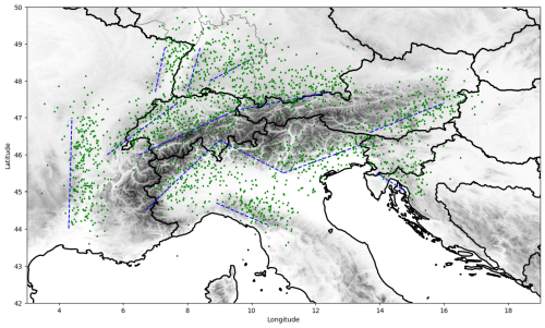
Hail is a severe meteorological hazard that can cause significant damage to infrastructure and agriculture. Studies on expected changes in hail severity in a warming climate and recent record-breaking hail impacts 2022 in France and 2023 in Italy highlight the importance of quantifying hail risk in a changing climate. As part of the Swiss hail research project scClim, we approach this question leveraging the first decadal convection-resolving climate simulations with the integrated hail diagnostic HAILCAST. Following a pseudo-global-warming approach, a present-day scenario with ERA5 boundary conditions from 2011-2021 is compared with a 3°C global warming scenario. We calibrate building vulnerability functions based on >100’000 hail damage reports from four Swiss building insurance companies. The calibrated model highlights the concentration of hail damages into few events with limited spatial extent, which entails a large uncertainty in the climate change signal based on a bootstrap sampling of originally modelled events. Assuming a building vulnerability as calibrated over Switzerland, hail damage potential is expected to increase in over 85% of the European countries within the modelling domain, with decreases primarily concentrated in France and the Iberian Peninsula. While the sampling uncertainty within the 11-year climate simulations clearly exceeds the climate change signal locally, we expect a clear hail damage potential increase of 25-42% aggregated over Europe. Beyond the expected changes in hail damage potential, this contribution highlights methodological aspects and key uncertainties of hail risk quantifications based on climate simulation data. In particular, we discuss the use of spatial resampling of hail swaths to capture worst-case events, the uncertainty in building vulnerability quantification, and the implications of the small spatial scale and local severity of damaging hail streaks.

How to cite: Schmid, T., Gebhart, V., and Bresch, D. N.: Modelling hail risk in Europe based on convection-resolving climate simulations: Methods and expected changes in a warming climate, 12th European Conference on Severe Storms, Utrecht, The Netherlands, 17–21 Nov 2025, ECSS2025-12, https://doi.org/10.5194/ecss2025-12, 2025.

14:45–15:00
|
ECSS2025-15
Steffen Münch, Paul Della-Marta, Niklaus Merz, Martin Frischknecht, and Leonie Villiger

Losses from hailstorms are increasingly affecting the re/insurance industry, with exceptionally high losses from the hail peril in France in 2022 and Italy in 2023. New scientific studies indicate that climate change may be driving modifications in atmospheric conditions, leading to more frequent large hail events.

We developed our new hail model for insurance losses in Europe by combining the AR-CHaMo dataset (Battaglioli et al., 2023) with radar data from the German Weather Service. By correlating hail probabilities to the area covered by thunderstorms in the radar data, we have created 100 plausible versions (stochastic simulations) of each day from 1950 to 2022, leading to a fully stochastic event-set with 7,300 years and about 80 million hail footprints over Europe.

Using this newly developed model, we investigate the annual aggregated insured loss for 1950-2022 per country and find that hail losses have increased by 0.8-1.7% per year (with lowest increase for Germany and the largest for Italy) due to the underlying trends in the reanalysis predictors of hail probability.

This analysis shows that climate change might be an important contributor (an estimated 20% to 55% of the total) to the annual expected change in risk of loss, compared to other changing risk factors such as exposure and inflation.

How to cite: Münch, S., Della-Marta, P., Merz, N., Frischknecht, M., and Villiger, L.: The contribution of climate change to Europe’s increasing hail losses, 12th European Conference on Severe Storms, Utrecht, The Netherlands, 17–21 Nov 2025, ECSS2025-15, https://doi.org/10.5194/ecss2025-15, 2025.

15:00–15:15
|
ECSS2025-26
Geert Lenderink, Hylke de Vries, Erik van Meijgaard, Bert van Ulft, and Rob Groenland

In this presentation we look into observations and results from convection-permitting weather/climate modeling to investigate how (extreme) convective rainfall and convective dynamics could change with global warming. Taking (sub)hourly rainfall observations, surprisingly regular relationships with surface dew point temperatures are found in data from The Netherlands and (central/southern) France, closely following two times the Clausius-Clapeyron relation. Even more so, given the same absolute humidity, lower relative humidity is associated with higher rainfall intensities. This points at important roles of dynamical feedback processes related to both relative and absolute humidity,  for instance due to latent heat release, cold pool dynamics and entrainment processes, affecting rainfall intensities and cloud organisation. Unsurprisingly, convection permitting climate models reproduce the above dependencies much better than conventional climate models. This is, in particular, the case for the dependency on relative humidity, where conventional, convection-parameterized models (12 km) do not capture the observed relationships.  Since climate change will likely lead to increases in absolute humidity, but decreases in relative humidity, it is important to understand these mesoscale/cloud dynamics. Here, we show results of a methodology that allows to study extremes and convective dynamics within the context of climate change using a convection permitting climate model. It is based on a forecasting system, using pseudo global warming as an approximation of climate change, running a small ensemble for various warming levels.  We illustrate the methodology with applications to a recent flood event in Italy (convection embedded into a large-scale system) and a mesoscale convective system/supercell north of the Alps. In particular, it is shown that rainfall extremes tend to concentrate in time and space in a warming world, disproportionately enhancing their impact. Also, the simulation of the super cell shows stronger downward motions in warmer climates (in particular for lower relative humidity futures) causing strong  increases in convective wind gusts. Finally, we  will discuss what can be learned from observed relationships based on day-to-day weather variability, and where  these relationships may deviate from long-term variability due to climate change.

How to cite: Lenderink, G., de Vries, H., van Meijgaard, E., van Ulft, B., and Groenland, R.: Convective systems and climate change in observations and model simulation using pseudo global warming. , 12th European Conference on Severe Storms, Utrecht, The Netherlands, 17–21 Nov 2025, ECSS2025-26, https://doi.org/10.5194/ecss2025-26, 2025.

15:15–15:30
|
ECSS2025-66
Robert Trapp, Sonia Lasher-Trapp, Duanne Claybrooke, and Olivia Romppainen-Martius

We employed a “storyline” approach to explore possible anthropogenic climate change influences on the extreme hail event in Switzerland on 28 June 2021, with a particular focus on hailfall near Zurich, Switzerland. The event was successfully simulated using the weather research and forecasting model configured over a European regional domain, with initial and boundary conditions from ERA5. An ensemble of factual simulations with randomly perturbed initial and boundary conditions was compared to an ensemble of counter-factual simulations in which a mean climate change signal was removed from the initial and boundary conditions. This signal was computed using differences between global climate model (GCM) data averaged over current-day and pre-industrial time intervals; data from six different GCMs yielded a range of climate change signals, thus contributing to the counter-factual ensemble.  Relative to factual simulations, counter-factual simulations exhibited overall less hail, particularly for diameters ≥ 3 cm. This tendency is consistent with relatively lower convective available potential energy but comparable melting depths in the counter-factual environments. We quantified the fraction of attributable risk and concluded that the geographical area covered by hail of diameter larger than 3 cm and 5 cm appears to have been increased by the meteorological changes attributable to climate change.

How to cite: Trapp, R., Lasher-Trapp, S., Claybrooke, D., and Romppainen-Martius, O.: A storyline climate-change attribution study of the extreme hail event in Switzerland on 28 June 2021, 12th European Conference on Severe Storms, Utrecht, The Netherlands, 17–21 Nov 2025, ECSS2025-66, https://doi.org/10.5194/ecss2025-66, 2025.

15:30–15:45
|
ECSS2025-34
Monika Feldmann, Michael Blanc, Sandro Beer, Lena Wilhelm, Killian Brennan, Iris Thurnherr, Patricio Velasquez, Olivia Martius, and Christoph Schär

Supercell thunderstorms are among the most damaging and hazardous weather phenomena. Due to heterogeneous observation networks, no comprehensive and homogeneous observation-based supercell climatology exists for Europe. Utilizing a km-scale 11-year current climate simulation, we derive a climatology for supercell thunderstorms in Europe, applying tracking to rotating updrafts in convection. Supercells cluster around mountain regions, with an absolute maximum in Northern Italy, and local maxima surrounding the entire Alps, the Massif Central, Pyrenees, and Dinaric Alps. With the same tracking in a +3°C global warming scenario, an 11% increase in supercell frequency is detected, accompanied by a spatial shift towards the northeast and higher altitudes. These patterns are also reflected in changes in instability, convective inhibition, and deep layer shear. Fundamentally, a drying of southwestern Europe is responsible for reductions in instability, causing a supercell frequency decrease. Using storm-centered composites, the pre-storm environment is analyzed. Overall, supercells occur in higher instability and shear, however the lower bound of the distribution remains approximately stable. Pre-storm environments are correlated with the intensity of convective hazards, such as hail size, lightning potential index, precipitation intensity, and wind gusts. These simulations provide the first pan-European supercell climatology from convection-resolving climate data, offering crucial insights into current and future hazard distributions.

How to cite: Feldmann, M., Blanc, M., Beer, S., Wilhelm, L., Brennan, K., Thurnherr, I., Velasquez, P., Martius, O., and Schär, C.: Supercell thunderstorms in Europe – insights from km-scale climate simulations, 12th European Conference on Severe Storms, Utrecht, The Netherlands, 17–21 Nov 2025, ECSS2025-34, https://doi.org/10.5194/ecss2025-34, 2025.

15:45–16:00
|
ECSS2025-17
Francesco Battaglioli, Pieter Groenemeijer, Tomáš Púčik, and Mateusz Taszarek

The Additive Logistic Regression Models (AR-CHaMo) for large (> 2 cm) and very large hail (> 5 cm) were applied to the CMIP6 multi-model ensemble to assess the future global occurrence of hail (2015-2100) under the high emission Socio-Economic Pathway scenario SSP5-8.5. The analysis focuses on three warming levels: 1.5°C, 2.0°C and 3.0 °C above pre-industrial levels. Under future climate scenarios, the locations of the hail frequency maxima are projected to remain consistent, with Northern Argentina and the South American tri-border region continuing to show the highest activity, followed by the US Great Plains and South Africa. The projected trends of large and very large hail differ considerably on a global scale: hail > 2 cm is expected to decrease in frequency across most regions, whereas hail > 5 cm is projected to increase in most hail-prone areas. Large differences are present across the US Plains and the tri-border region of South America, where hail > 2 cm is expected to decline, while hail > 5 cm exhibits strong positive trends. The presentation will analyse the physical drivers of these trends to understand the origin of the differences with the historical trends that resulted from the application of AR-CHaMo to ERA5 (1950-2023), especially across South America. In Europe and the Middle East, widespread increases in the frequency of hail > 5 cm are projected, while hail > 2 cm is expected to decrease in the southern Mediterranean and across northern Africa. When comparing historical and future trends, only one region shows consistency in the sign of the trends for both hail > 2 cm and > 5 cm: northern Italy and the surrounding Alpine region. This finding fits with the record-breaking hailstorms of 2023 and supports high confidence in the projected increase in hail events in this region.

How to cite: Battaglioli, F., Groenemeijer, P., Púčik, T., and Taszarek, M.: The Future of (Very) Large Hail Globally: Application of the AR-CHaMo models to the CMIP6 Ensemble, 12th European Conference on Severe Storms, Utrecht, The Netherlands, 17–21 Nov 2025, ECSS2025-17, https://doi.org/10.5194/ecss2025-17, 2025.

16:00–16:15
|
ECSS2025-84
David Sills, Julian Brimelow, Connell Miller, and Gregory Kopp

The Canadian Severe Storms Laboratory (CSSL) was launched at Western University in October of 2024 with the aim of being the authority for severe convective storm (SCS) data and research in Canada. The CSSL will advance the detection, documentation and understanding of SCS and their impacts across the country.

The CSSL’s mission is currently driven by three key projects: the Northern Tornadoes Project, the Northern Hail Project, and the Northern Mesonet Project. The Northern Tornadoes Project aims to improve tornado, downburst and derecho detection and documentation across Canada, utilizing aerial and ground surveys, satellite imagery and advanced research methods to improve the Canadian climatology and analyze trends.

The Northern Hail Project focuses on understanding hailstorm frequency, intensity, and impacts, leveraging radar observations, hail collection and damage assessments to better characterize hail hazards.

The Northern Mesonet Project supports these initiatives by increasing the spatial density of real-time advanced weather observations, enhancing data availability, and improving data quality for SCS analysis and prediction.

It is anticipated that an additional project, focused on flash flooding hazards related to SCS, will be launched under the CSSL banner in the coming years. Some work has already begun in that area.

The CSSL also provides unique training opportunities through its graduate student and internship programs. These programs aim to cultivate the next generation of SCS researchers by offering hands-on experience with in-field data collection, techniques development and applied research.

This presentation will outline the strategic framework and technological advancements that underpin the CSSL’s operations and research. It will also showcase the latest findings from each project and explore future directions.

How to cite: Sills, D., Brimelow, J., Miller, C., and Kopp, G.: The CSSL – A New Era in Severe Storms Data and Research in Canada, 12th European Conference on Severe Storms, Utrecht, The Netherlands, 17–21 Nov 2025, ECSS2025-84, https://doi.org/10.5194/ecss2025-84, 2025.

Orals FR3: Fri, 21 Nov, 11:15–13:15 | Room Hertz Zaal

11:15–11:30
|
ECSS2025-224
Mateusz Taszarek, Tomas Pucik, Cameron Nixon, John T. Allen, Pieter Groenemeijer, John M. Peters, Francesco Battaglioli, Bruno Ribeiro, Hernan Bechis, Andrew Dowdy, and Harold Brooks

Parameter studies for convective storm environments have historically focused on single continents. Here, we considered severe weather reports (hail, tornadoes, severe convective winds), lightning detection data and ERA5 reanalysis across four parts of the world: Europe, Australia, South America, and the United States. We analyzed convective parameters and vertical profiles of atmospheric quantities for severe and non-severe thunderstorms to better understand which environmental features share similarities among continents and reliably represent convective hazards. Thermodynamic parameters are the most useful proxies of hail and warm season severe winds, whereas kinematic parameters are the most robust predictors of storm severity, especially tornadoes, whose environments feature large contribution of low-level streamwise vorticity. Hail experiences weak near ground winds and the strongest bulk wind shear between 1–3 km while tornadoes and severe winds have the largest shear near ground. Larger hail and stronger tornadoes can be expected with increasing storm-relative winds, moisture fluxes, and mid-tropospheric ventilation (i.e. wind component perpendicular to inflow axis). Extending hodograph to its origin while calculating storm-relative helicity and streamwise vorticity improves tornado prediction, especially for shallow layers (0–100 m). Lifted parcel buoyancy in the hail growth layer (-10°C to -40°C) is important for assessing likelihood of hail. Using peak parcel buoyancy (instead of integrated) leads to more skilful predictions of hail and tornadoes, especially when entraining parcel calculation procedure is incorporated . We also note that some parameters are geographically dependent (e.g. lapse rates), and that parameters, which are good predictors for the occurrence of convective hazards, are typically not the best parameters of their intensity. 

How to cite: Taszarek, M., Pucik, T., Nixon, C., Allen, J. T., Groenemeijer, P., Peters, J. M., Battaglioli, F., Ribeiro, B., Bechis, H., Dowdy, A., and Brooks, H.: What do large hail, tornado and severe thunderstorm wind environments have in common across continents?, 12th European Conference on Severe Storms, Utrecht, The Netherlands, 17–21 Nov 2025, ECSS2025-224, https://doi.org/10.5194/ecss2025-224, 2025.

11:30–11:45
|
ECSS2025-319
Dominique Brunet, Mateusz Taszarek, Jerry Su, and John Hanesiak

Forecasting lightning from environmental parameters is well established for mid-latitude regions over land. A combination of lifted index (LI), convective available potential energy (CAPE), convective inhibition (CIN) and relative humidity in the mid-troposphere are known to be good predictors of lightning occurrence. However, forecasting lightning globally with these parameters is less skillful, particularly in the tropics and ocean surface. Using the XGBoost machine learning method, we implemented a global lightning forecast from a selection of environmental parameters derived from ERA5 and thundeR package. The method is trained efficiently on several millions of pairs between global lightning observations and hundreds of convective parameters. In a first experiment, called BigXGB, we trained models over the entire globe using all parameters. For a second experiment, called RegionalizedXGB, we trained four different models for : land mid-latitude (LM), ocean mid-latitude (OM), land tropics (LT) and ocean tropics (OT). Finally, in a third experiment we incrementally dropped the least important feature in term of information gain until only one feature remained. When trained on years 2019-2022, BigXGB achieved a ROC-AUC score of 0.94 for entire domain (LM: 0.97, LT: 0.92, OM: 0.98, OT: 0.95) on the 2023 test year, with a special CIN formulation (MU5_CIN_4km), a special LI formulation (MU5_LI_eff), total column cloud ice water (tciw), and total column liquid supercooled water (tcslw), being the four most important features.  RegionalizedXGB obtained similar scores to BigXGB when using the same set of features, but with the most important features varying by region. The most important features for LM and OM were related to LI, CIN and CAPE while for LT and OT the most skillful predictors were more diversified. Incrementally dropping features showed that only 40-50 features are necessary to obtain top performance, with significant performance declines below 15 features. Many top convective parameters are variants of different parcel types (most-unstable, mixed-layer, etc.), indicating that a variety of flavours of the same convective parameters help to increase predictive accuracy. A calibrated probabilistic lightning occurrence forecast was then obtained by isotonic regression between raw uncalibrated predictions and frequency of observations. This new global lightning prediction machine learning-based model opens the door to design global lightning climatology for the past 75 years and for implementing accurate lightning diagnostics in operational global numerical weather prediction.

How to cite: Brunet, D., Taszarek, M., Su, J., and Hanesiak, J.: Machine Learning-based Global Lightning Prediction from Convective Parameters, 12th European Conference on Severe Storms, Utrecht, The Netherlands, 17–21 Nov 2025, ECSS2025-319, https://doi.org/10.5194/ecss2025-319, 2025.

11:45–12:00
|
ECSS2025-156
Natalia Pilguj, Artur Surowiecki, Mateusz Taszarek, and Krzysztof Piasecki

Each year, an average of 184 quasi-linear convective systems (QLCSs), including 6 derechos, occur across different parts of Europe, posing a significant societal impact. In this work, we analyze synoptic patterns and convective environments associated with QLCSs, considering their intensity and spatiotemporal variability. For this analysis, we used the QLCS database with 1469 manually identified cases based on the OPERA radar data, over a period of 8 years (2014–2021). For each case, we have chosen a representative ERA5 vertical profile representing the pre-convective environment ahead of the QLCS. In the performed analysis of synoptic-scale patterns, we found that warm-season cases develop primarily under large atmospheric instability setups, whereas during the cold part of the year, large-scale lift with marginal (but non-zero) CAPE and high vertical wind shear is the most common trigger. The mean vertical profiles presented in this work indicate the dominance of westerly and southwesterly flow, accompanied by steep mid-level lapse rates and small relative humidity over this layer. Except for warm-season QLCSs over the West and cold-season cases in Central Europe, QLCSs are associated with clockwise-curved mean hodographs. Analysis of convective parameters indicates that the intensity of warm-season QLCSs is well represented by downdraft-related metrics. Marginal and stronger QLCSs, including derechos, can be distinguished using atmospheric instability (CAPE), especially across Central Europe. Upper-level bulk wind shear was found to discriminate well between the severity of QLCSs in the cold season.

How to cite: Pilguj, N., Surowiecki, A., Taszarek, M., and Piasecki, K.: Quasi-linear convective systems and derechos across Europe: ERA5 convective environments and synoptic-scale patterns, 12th European Conference on Severe Storms, Utrecht, The Netherlands, 17–21 Nov 2025, ECSS2025-156, https://doi.org/10.5194/ecss2025-156, 2025.

12:00–12:15
|
ECSS2025-68
Boris Blanc, Timothy Raupach, Lisa Alexander, and Shirley Qin

Hailstorms are a leading cause of insured losses in Australia, damaging vehicles, buildings, and agriculture amongst other infrastructure. Individual hailstorms have caused damage bills exceeding AUD$1b, particularly in the densely populated cities of Brisbane and Sydney on Australia’s east coast. Despite hail’s high damage potential, the drivers of the large observed interannual variability in large-hail events in Australia remain highly uncertain.
Here, we use the radar product Maximum Expected Size of Hail (MESH) to investigate the drivers of interannual hail variability across Australia’s most hail-affected regions. We use a MESH threshold of 30 mm for hail occurrences. Various studies have mentioned that MESH is a good discriminator for hail occurrences and that a great proportion of hailstorms and hail reports are captured by a 30-mm MESH threshold. We examine how different drivers of variability such as the El Niño Southern Oscillation (ENSO), Southern Annular Mode (SAM), and Indian Ocean Dipole (IOD) affect large-hail occurrence in Australia. We focus on areas where hailstorms cause the greatest damage, to perform a robust analysis of year-to-year variations in large-hail occurrences.
We found a strong correlation between the ENSO 3.4 index and large hail occurrences in Australia, mainly around these major cities of Sydney and Brisbane. We will present the results of our analysis for the Australian east coast’s most impacted cities: Sydney, Brisbane, Melbourne, and Canberra. This includes analysis of the interannual variability and its connection to large-scale climate drivers, convective parameters, and future research needs.

How to cite: Blanc, B., Raupach, T., Alexander, L., and Qin, S.: Understanding the Interannual Variability in Severe Hail Storms in Australia, 12th European Conference on Severe Storms, Utrecht, The Netherlands, 17–21 Nov 2025, ECSS2025-68, https://doi.org/10.5194/ecss2025-68, 2025.

12:15–12:30
|
ECSS2025-209
|
Lena Wilhelm, Katharina Schrooer, Cornelia Schwierz, and Olivia Martius

The new long-term (1959-2022) reconstruction of Swiss hail days by Wilhelm et al. (2024) reveals substantial natural year-to-year variability in hail activity and a pronounced seasonal cycle. Building on these findings, this study aims to identify the drivers behind this variability, in particular, local and remote atmospheric, ocean and surface conditions that distinguish hail-active from hail-sparse summers. To investigate these mechanisms, we analyze composites of potential drivers, comparing seasons and months with high versus low hail frequency.

Our results show that strong hail seasons in northern Switzerland are associated with anomalously warm sea surface temperatures (SSTs) in the Mediterranean, cool SSTs in the northern and eastern Atlantic, elevated skin temperatures and dry soils in Central Europe, and a distinct wave train in the 500 hPa geopotential height field, with a trough upstream over the Atlantic and a ridge over the study region. We find a strong coupling between the large-scale atmospheric circulation, Central European land-surface conditions, and surrounding SSTs. These patterns contrast clearly with those during weak hail seasons and differ between northern and southern Switzerland, indicating regional signals and potential for predictability. Furthermore, we identify precursors of strong hail seasons by examining SSTs, snow cover, and sea ice during the preceding winter and spring. These relationships are then leveraged to build a first seasonal prediction model aimed at classifying hail seasons as strong, average, or weak, providing a valuable step toward anticipating hailstorm risk several months in advance.

How to cite: Wilhelm, L., Schrooer, K., Schwierz, C., and Martius, O.: On Hailstorm Variability in Switzerland: Key Drivers for Seasonal Predictability, 12th European Conference on Severe Storms, Utrecht, The Netherlands, 17–21 Nov 2025, ECSS2025-209, https://doi.org/10.5194/ecss2025-209, 2025.

12:30–12:45
|
ECSS2025-139
Detection and Attribution of Trends in Giant Hail Events in Northern Italy: A Circulation Analogs-Based Approach
(withdrawn)
Flavio Pons, Francesco De Martin, and Luca Famooss Paolini
12:45–13:00
|
ECSS2025-148
Shakti P.c., Kohin Hirano, and Satoshi Iizuka

In recent years, Japan has experienced a notable increase in extreme rainfall events, which have frequently triggered severe flooding, resulting in significant loss of life and property damage. Consequently, the overall cost of flood-related disasters has continued to rise. Climate change projections indicate that the frequency and intensity of such extreme events are likely to increase in the future.
With advancements in observational technologies, high-resolution radar-based rainfall data are now available in near real-time across Japan, providing valuable input for flood risk assessment. In this study, we rapidly developed a flood risk mapping framework using a combination of radar rainfall data, hydrological data, historical rainfall records, and various physiographic factors. The risk assessment was conducted using a Geographic Information System (GIS)-based Analytic Hierarchy Process (AHP) approach, focusing on past extreme events.
Our analysis produced several risk maps, including real-time hydrological hotspot maps and overall flood susceptibility maps for specific extreme rainfall events. To validate our results, we compared them with observed flood damage data and insurance claim records. The comparison showed promising agreement, suggesting the reliability of our approach. However, further refinement is necessary to enhance the robustness and predictive capability of the method. We believe the proposed methodology offers a valuable tool for flood disaster risk management and can support decision-making for stakeholders preparing for future extreme flood events.

How to cite: P.c., S., Hirano, K., and Iizuka, S.: Assessing Flood Risk During Extreme Rainfall Events: Case Studies from Recent Events in Japan, 12th European Conference on Severe Storms, Utrecht, The Netherlands, 17–21 Nov 2025, ECSS2025-148, https://doi.org/10.5194/ecss2025-148, 2025.

13:00–13:15
|
ECSS2025-54
Carlos Calvo-Sancho, Javier Díaz-Fernández, Juan Jesús González-Alemán, Amar Halifa-Marín, Mario Marcello Miglietta, Cesar Azorin-Molina, Andreas F. Prein, Ana Montoro-Mendoza, Pedro Bolgiani, Ana Morata, and María Luisa Martín

Cut-off lows are, and will be in the future, one of the main threats related to severe weather in the Iberian Peninsula, especially in the eastern Mediterranean fringe. Cut-off lows are often accompanied by heavy precipitations in a short time promoting flash-floods, as well as hail, severe straight-line winds and tornadoes.   

On the week of October 27th – November 4th, 2024, a cut-off low affected the Iberian Peninsula with impactful socio-economic consequences- in several Spanish regions and, especially, in the Valencia area. The severe weather phenomena on the surface have differed depending on the region: large hail (5-7 cm), several tornadoes, strong wind gusts and, above all, extreme precipitations. The most severe day was October 29th in the Valencia region, with rainfall accumulations higher than 300 mm in a notable area and locally registering 771 mm in 24 hours. In addition, the Turís official weather station recorded numerous national records for rainfall intensity. Moreover, the convective system developed 11 tornadoes (two of them with intensity IF2) and large hail (~ 5 cm). The social impact of the floods in Valencia was very high, with more than 16.5 billion euros of damage to infrastructure (roads, railways, etc.), housing and croplands, as well as 225 fatalities.

In this survey, we focus on Valencia’s floods on October 29th. Here, by performing model simulations with the WRF-ARW model and employing a storyline approach, we find a 21% increase in the 6-hour rainfall intensity, a substantial 55% increase in areas with extreme accumulated rainfall exceeding the 180 mm threshold, and a 19% increase in total rainfall volume over the Jucar River catchment—attributable to current anthropogenic climate conditions compared to preindustrial conditions. Moreover, the enhanced available water vapor content played a central role, while CAPE, diabatic heating, and stronger vertical velocities boosted convective processes. A deeper warm cloud layer and elevated graupel concentration reveal microphysical mechanisms that enhanced precipitation volumes in a warmer climate, exceeding Clausius-Clapeyron scaling.

This study highlights the growing risks in the Mediterranean area and the urgent need for effective adaptation in urban planning to reduce the hydrometeorological extremes due to the human-induced climate change.

How to cite: Calvo-Sancho, C., Díaz-Fernández, J., González-Alemán, J. J., Halifa-Marín, A., Miglietta, M. M., Azorin-Molina, C., Prein, A. F., Montoro-Mendoza, A., Bolgiani, P., Morata, A., and Martín, M. L.: Storm Dynamics-based Attribution to the Valencia’s deadly floods, 12th European Conference on Severe Storms, Utrecht, The Netherlands, 17–21 Nov 2025, ECSS2025-54, https://doi.org/10.5194/ecss2025-54, 2025.

Posters TU4: Tue, 18 Nov, 14:30–16:00 | Poster area

Display time: Mon, 17 Nov, 09:00–Tue, 18 Nov, 18:30
P73
|
ECSS2025-1
Ken-Chung Ko

A TC-removed technique was applied to global analyses to study the impact of TCs on the summertime subtropical ISO propagating over the western North Pacific (WNP). The TC-removed ISO pattern showed a westward shift from the area between Taiwan and Japan to the northern South China Sea. The monsoon trough thus weakened after TCs were removed from the circulation fields. Furthermore, the interaction between the ISO and submonthly wave patterns also showed weaker signals after TC removal. However, the activity over the South China Sea remained considerable strong because fewer TCs passed through this area. Therefore, the ISO and submonthly wave patterns retained considerable intensity over the South China Sea. The higher frequency of TC occurrences in the westerly phase results in a more pronounced energy reduction following TC removal compared to the easterly phase. Moreover, synoptic-wave PKE exceeds its submonthly counterpart, and the baroclinic conversion exhibits a north-south orientation, both due to the upstream recurving TCs that redirect their paths toward Japan. These findings reinforce our knowledge of climate variability, thus advancing climate modeling accuracy.This research underscores TCs' substantial impact on atmospheric circulations, highlighting their role in coordinating the submonthly wave patterns, synoptic waves, and ISOs in the WNP. This enhanced knowledge facilitates a more accurate explanation of climate variability. Nevertheless, comprehensive analyses and assessments across the global domain are essential to fully include the broader implications and variability of TC interactions with atmospheric perturbations worldwide.

How to cite: Ko, K.-C.: TCs’ contribution on summertime subtropical ISOs and submonthly wave patterns over the western North Pacific, 12th European Conference on Severe Storms, Utrecht, The Netherlands, 17–21 Nov 2025, ECSS2025-1, https://doi.org/10.5194/ecss2025-1, 2025.

P74
|
ECSS2025-16
Francesco Battaglioli, Pieter Groenemeijer, Mateusz Taszarek, and Tomáš Púčik

Additive Logistic Regression Models (AR-CHaMo) to predict the occurrence of tornadoes of intensity > (E)F1 were developed using lightning observations from the Arrival Time Difference Network (ATDnet), tornado reports from the European Severe Weather Database (ESWD), the Storm Prediction Centre (SPC) and the Australian Bureau of Meteorology (BOM) and environmental predictors from the ERA5 reanalysis. The models output the probability of a tornado as a function of environmental predictors from ERA5 and can be used both for forecasting and climate analysis. By applying the models to ERA5 for the period 1992-2023, we were able to map the modelled climatological occurrence of tornadoes > (E)F1 on a global scale. According to AR-CHaMo, tornadoes are most common across the Plains and the Southeast of the US, but also across Uruguay, Paraguay, and southern Brazil. Local hotspots are also modelled across southeastern South Africa, southeastern Australia, as well as southeastern and northeastern China. Conditions favouring tornadoes are climatologically less frequent in Europe, but local hotspots are present across coastal regions of the Mediterranean. Although a ground-based verification is impossible due to the lack of a globally consistent tornado reports database, the modelled spatial distribution from AR-CHaMo is in agreement with local climatologies from regions where reports are collected, such as the US and South America. Using 31 years of time series, we were able to detect long-term trends in modelled tornado frequency. In North America, AR-CHaMo indicates that tornadoes have increased in frequency across the US Southeast (most strongly) and the Upper Midwest, while they have locally decreased in the Great Plains. Large relative increases are also present in southeastern Canada. Trends are negative across South America, southern China, and Australia, while the occurrence has increased across southeastern Asia and locally in southern Europe. As part of the presentation, we will also report on the forecasting applications of the AR-CHaMo models, while focusing on a few recent tornado outbreaks across Europe and the US.

How to cite: Battaglioli, F., Groenemeijer, P., Taszarek, M., and Púčik, T.: A Statistical Model to Forecast Tornadoes and Reconstruct Their Climatology and Trends Globally, 12th European Conference on Severe Storms, Utrecht, The Netherlands, 17–21 Nov 2025, ECSS2025-16, https://doi.org/10.5194/ecss2025-16, 2025.

P75
|
ECSS2025-28
Jakub Wyrwas and Zuzanna Bielec-Bąkowska

Due to anthropogenic climate change, warmer and almost snowless winters are increasingly observed in mid-latitudes, including Poland. As a result, air masses can transport more moisture, making them more unstable, potentially leading to more convective phenomena, including thunderstorms. Although thunderstorms occurring in the cold half of the year, especially in winter, are extremely rare and not as dangerous as summer thunderstorms, they can be classified as extreme weather phenomena. At the same time, the increase in their frequency is another signal of climate change. 

This study presents changes in the occurrence of thunderstorms in the cold half of the year and in winter in Poland from 1951 to 2020. The research was based on data from 46 synoptic stations of the Institute of Meteorology and Water Management – National Research Institute (IMGW-PIB), and the basic indicator was a day with a thunderstorm. 

Studies have shown a clear spatial differentiation of thunderstorms occurring in the cold half of the year, which in some regions of the country accounted for even more than 8% of all cases in the year. The strongest influence on the occurrence of these phenomena in the cold season is air circulation and local conditions (especially the impact of the Baltic Sea in the north and varied topography in the south). In Poland in the period 1951–2020, there were on average 13.1 days with a thunderstorm from October to March (days where at least one station recorded a thunderstorm), including 3.4 days during meteorological winter. The number of such days at individual stations ranged from 0.5 to 1.8 and 0.01 to 0.59, respectively. In the period under study in Poland, the number of thunderstorm days in the cool season slowly increased, and the increase amounted to 0.35 days per decade. Most of the thunderstorms considered were associated with atmospheric fronts. The strongest occurred during the passage of dynamic cold fronts, which are characterised by low potential energy and high wind shear values.

How to cite: Wyrwas, J. and Bielec-Bąkowska, Z.: Long-term variability of winter thunderstorms in Poland (1951–2020), 12th European Conference on Severe Storms, Utrecht, The Netherlands, 17–21 Nov 2025, ECSS2025-28, https://doi.org/10.5194/ecss2025-28, 2025.

P76
|
ECSS2025-44
Rebekka Koch, Andreas Prein, Ulrike Lohmann, and Neil Aellen

Over the past decade, hail has been responsible for most financial losses associated with severe convective storms, with costs steadily increasing. As the population grows and increasingly invests in vulnerable infrastructure, the risk of economic damage from large hail also rises. Accurate hazard assessment is therefore essential for effective mitigation.

While recent machine learning (ML) approaches have enabled the development of hail climatologies for hazard assessment, many existing datasets remain limited by regional biases and coarse spatial or temporal resolution.

This study aims to produce a novel, high-resolution large hail (> 2.5 cm in diameter) hazard climatology for the Contiguous United States (CONUS) using the gradient-boosted decision tree algorithm XGBoost. Our model will integrate multiple remotely sensed hail proxy observations, including hourly satellite-derived brightness temperature, radar-reflectivity, and lightning counts, along with key hail-related environmental parameters derived from the ERA5 reanalysis. The high resolution of the remotely sensed data will enable us to train the ML model at an unprecedented grid spacing of 4 km × 4 km, enhancing the spatial detail of large hail climatologies derived in previous datasets.

We will assess model performance using held out test data and compare regional calibration across different climate regimes in the CONUS. Our research will also explore which predictors are most influential for large hail estimation and how effectively the model captures spatial heterogeneities in hail occurrence.

The resulting dataset will represent a refined tool for hail risk assessment in the CONUS. Moreover, with globally available satellite and reanalysis data, this framework also holds the potential for expanded application in other regions around the world.

How to cite: Koch, R., Prein, A., Lohmann, U., and Aellen, N.: A Machine Learning Based High-Resolution Large Hail Climatology for the Contiguous United States , 12th European Conference on Severe Storms, Utrecht, The Netherlands, 17–21 Nov 2025, ECSS2025-44, https://doi.org/10.5194/ecss2025-44, 2025.

P77
|
ECSS2025-45
Deconstructing Wind Storm Impacts for Risk Assessment: The Role of Duration, Gust Factor, and Precipitation in Residential Building Damage in Germany
(withdrawn)
Andreas Trojand, Henning Rust, and Uwe Ulrbich
P78
|
ECSS2025-61
Petr Zacharov and Robert Kvak

In this study, we investigate the representation of atmospheric conditions favourable for severe convective storms using two different reanalyses: the regional, convection-permitting ALADIN model with a horizontal resolution of 2.3 km, and the global ERA5 dataset produced by the ECMWF, featuring a resolution of 0.25°. We focus on two essential environmental parameters: Most Unstable Convective Available Potential Energy (MUCAPE) and deep-layer (0–6 km) wind shear, which are widely used in both operational forecasting and climatological analyses of convective environments.

The comparison is performed for the region of Central Europe, with a dual focus. First, a point-based evaluation is conducted using vertical profiles from the upper-air sounding station Prague-Libuš, covering the period 1992–2019. This long-term observational reference enables a detailed assessment of the performance and consistency of both reanalyses in capturing convective parameters. Second, we examine the spatial distribution and seasonal characteristics of MUCAPE and wind shear fields over a broader Central European domain, based on daily data from the period 1991–2020.

By analysing both local and regional characteristics, we aim to better understand the strengths and limitations of each reanalysis in capturing convective potential and storm-related wind profiles. These findings are relevant for applications in climatology, model validation, and long-term assessments of severe weather risk in the region.

How to cite: Zacharov, P. and Kvak, R.: Comparison of convective precursors from ALADIN and ERA5 Reanalyses over Central Europe, 12th European Conference on Severe Storms, Utrecht, The Netherlands, 17–21 Nov 2025, ECSS2025-61, https://doi.org/10.5194/ecss2025-61, 2025.

P79
|
ECSS2025-72
Kathrin Wapler, Marcus Beyer, and Paul James

While mesoscale processes are generally associated with the development of severe convective events, it is the synoptic situation that creates the environment for convective events. Thus the knowledge of the synoptic and mesoscale conditions are crucial for forecasting such events, while statistical analyses are helpful for raising a general awareness of the possibility of severe convective events. Beyer et al. 2025 recently performed a statistical analysis of the occurrence of tornadoes in Germany. This study is now expanded with the goal of analysing the occurrence and characteristics of tornadoes under different synoptic conditions.

The study is based on data from the European Severe Weather Database (ESWD), with 1812 confirmed tornado reports within Germany from 1940 to 2024, together with an automatic classification of synoptic patterns. The automatic method, GWL-REA, is broadly based on a pattern correlation method using ERA5 reanalyses, with various optimizations and AI-based enhancements. Four meteorological variables are used for the inputs: mean-sea-level pressure, geopotential height at 500 hPa, 500–1000 hPa relative thickness and the total column precipitable water. Classifications are available from 1940 up to the present. The most widely used set of circulation patterns are the 29 Hess–Brezowsky Grosswetterlagen (GWL) for Central Europe. These are intuitively defined and named patterns which are in common use amongst synoptic meteorologists. They have been used e.g. in a study of thunderstorms under different synoptic patterns by Wapler and James (2015). The classification has since been slightly updated: The pattern BM (Zonal Ridge across Central Europe) has been split into an anticyclonic (BMa) and a cyclonic (BMz) representation. This yields 30 synoptic patterns.


The analysis reveals conditions favourable for tornadic storm development and highlights regions affected under different flow regimes. Additionally, the analysis shows that different synoptic conditions are typically associated with specific tornado characteristics, such as the direction of movement or tornado severity. These relationships can be explained meaningfully via a description of the synoptic-meteorological characteristics of each weather pattern.


The Grosswetterlagen Wz (Cyclonic Westerly) and SWz (Cyclonic South-Westerly) have been identified as patterns inducing the most tornadoes over Germany. Wapler and James (2015), found that the Grosswetterlagen most frequently associated with thunderstorms are Sz (Cyclonic Southerly), SEa (Anticyclonic South-Easterly), SWz (Cyclonic South-Westerly), TrW (Trough over Western Europe) and TB (Low over the British Isles).

How to cite: Wapler, K., Beyer, M., and James, P.: Tornado occurrence and characteristics in Central Europe under different synoptic conditions , 12th European Conference on Severe Storms, Utrecht, The Netherlands, 17–21 Nov 2025, ECSS2025-72, https://doi.org/10.5194/ecss2025-72, 2025.

P80
|
ECSS2025-75
|
Andreea Bărăscu, Bogdan Antonescu, Dragoș Ene, Monica Ioniță, Ottilia Rusz, and Thilo Kühne

Tornadoes are violent natural hazards that can cause significant damage and human casualties. Due to their severe and localized impact, they are considered among the most significant small-scale weather phenomena. In this study, we are expanding the existing Romanian tornado database by meticulously documenting additional tornadic events found in historical sources. Thus, we have conducted searches in recently available digital newspaper archives for tornado reports. The search yielded records dating as far back as the late nineteenth century, with the earliest events recorded in 1880. To the existing 199 tornadoes from the Romanian tornado database within the European Severe Weather Database (ESWD), we have added another 46 verified events.  The archival research conducted in this study has uncovered evidence of previously undocumented deadly tornadoes, consequently raising the number of deadly tornadoes in Romania from four to seven.

These 245 tornadoes reported between 1634 and 2024 were then used to construct an enhanced climatology of tornadoes in Romania. Spatial analysis of the updated database indicates a higher frequency of reports from northeastern and southeastern Romania. Temporally, most tornadoes (70%) occur during the warm season (May–July), with a peak in the early afternoon (47%, between 14:00 and 16:00 UTC).

To investigate the environmental conditions associated with tornado occurrence, we analysed a subset of post-1990 cases, up to 2024, using ERA5 reanalysis data. Only tornadoes with time accuracy better than or equal to one hour were included. The comprehensive analysis of tornado records spanning over three centuries and the inclusion of newly documented events significantly contribute to our understanding of tornado climatology in Romania.

This study not only enhances our knowledge of tornadic events in the region but also provides valuable insights into the environmental conditions conducive to tornado formation, thereby improving tornado forecasting and mitigation strategies. The results suggest that many Romanian tornadoes form in high-shear, low-CAPE (HSLC) environments, consistent with findings from other parts of Europe.

How to cite: Bărăscu, A., Antonescu, B., Ene, D., Ioniță, M., Rusz, O., and Kühne, T.: Tracing Tornadoes Through Time: Enhancing Tornado Climatology in Romania with Historical Data and Modern Analysis, 12th European Conference on Severe Storms, Utrecht, The Netherlands, 17–21 Nov 2025, ECSS2025-75, https://doi.org/10.5194/ecss2025-75, 2025.

P81
|
ECSS2025-80
Climatology and Impact Assessment of Severe Wind-Producing Convective Storms in Romania (2003–2024)
(withdrawn)
Marilena Zuzeac, Bogdan Antonescu, Dragos Ene, and Ileana Calotescu
P82
|
ECSS2025-93
Timothy Raupach and Joanna Aldridge

Hail is a leading cause of property and crop damage in Australia, with individual events capable of inflicting over $1b worth of insured losses. Hail damage is increased if hailstones are larger, if there are coincident strong winds, and if hail swaths cover larger areas. Australia’s most populated region is also its most hail prone, meaning the country has high exposure to hail hazard. While hailstorms are expected to be affected by climate change, the details of changes are non-stationary and subject to high uncertainty. Here, we use downscaled simulations over major Australian cities to examine projected changes in hail frequency, damage potential, and swath properties under a climate change scenario with ~2.4 degrees C warming. The areas we consider cover more than 65% of Australia’s population. We used extreme value analysis to analyse changes in maximum hailstone size and hail-proximal wind speeds. We used object-based analysis to summarise swath properties and compare them between epochs. The simulations project increases in hail frequency in Sydney/Canberra and Brisbane regions, increases in maximum hail size around Melbourne, Sydney/Canberra, Kalgoorlie, and Perth, and decreases in hail-proximal wind speeds around Perth, Melbourne, Sydney/Canberra. This study provides the most comprehensive projections for changes in hail damage potential under climate change in Australia to date.

How to cite: Raupach, T. and Aldridge, J.: Projected changes in hail damage potential and swath properties over Australian cities under global warming, 12th European Conference on Severe Storms, Utrecht, The Netherlands, 17–21 Nov 2025, ECSS2025-93, https://doi.org/10.5194/ecss2025-93, 2025.

P83
|
ECSS2025-96
|
Songning Wang, Robert Trapp, John Allen, Deepak Gopalakrishnan, and Eric Robinson

Convection-permitting dynamical downscaling (CPDD) allows for an explicit representation of the storm-scale generators of tornadoes, hail, severe thunderstorm winds, and locally heavy precipitation. Possible changes in such hazardous convective weather (HCW) due to human-induced climate change are therefore projected with higher confidence using CPDD than with analyses of relatively coarse global climate models (GCM). However, the computational resources necessary for CPDD are significant and therefore CPDD-based future projections of HCW have tended to be based on a single experiment, and thus absent of uncertainty measures otherwise determined with an ensemble of experiments via an ensemble of GCMs. Herein we present “environment-informed” CPDD as a means to efficiently generate a CPDD ensemble driven by different GCMs. This variant of CPDD is applied only to a subset of days and geographical domains over which the meteorological conditions potentially favor supercell thunderstorms, which are the most frequent generators of significant HCW. The temporal and geospatial occurrence of supercells over the United States is demonstrated from the perspective of environment-informed CPDD as applied to eight different GCMs and ERA5 reanalysis. Such occurrences vary considerably from downscaled GCM to GCM, thus demonstrating the value of an ensemble. Based on the ensemble mean, future supercell occurrence is projected to be most frequent over an area centered on the Missouri Bootheel. An earlier-start to the annual cycle of HCW risk is also projected.

The CPDD ensemble is also used to inform future projections of tornado, hail, and severe wind occurrences. Such occurrences are based on proxies developed using storm reports and CPDD simulations driven by ERA5. Consistent with the supercell projections, we find that tornado, hail, and severe wind occurrences generally tend to increase in the future over the central U.S., and decrease in the future over the southern half of Texas.

We will discuss how this methodology might be applied across Europe, and also how it forms the basis for machine learning applications.

How to cite: Wang, S., Trapp, R., Allen, J., Gopalakrishnan, D., and Robinson, E.: Climate-change projections of hazardous convective weather using an environment-informed, convection-permitting, dynamical downscaling ensemble, 12th European Conference on Severe Storms, Utrecht, The Netherlands, 17–21 Nov 2025, ECSS2025-96, https://doi.org/10.5194/ecss2025-96, 2025.

P84
|
ECSS2025-113
Robert Doe and the Tornado and Storm Research Organisation (TORRO)

A new tornado map for the United Kingdom and Ireland has been created for the years 1054-2025. This builds on an initial map which was first produced and published by the Tornado and Storm Research Organisation (TORRO) in 2015. Therefore, after a decade of receiving much new and also revised information, especially from detailed site investigations and updated historical data, this map presents a valuable contribution to better understanding tornado climatology. The United Kingdom is the only country in the world with a record of tornadoes (and waterspouts) for some 971 years. Presenting these tornadic events spatially with reference to intensity and seasonality allows the reader to infer much useful information. This presentation will examine the events, trends and hotspots. It will examine regionality, bias, and historical reporting along with presenting a striking visual of tornado climatology for the United Kingdom and Ireland.

TORRO was established in 1974 (www.torro.org.uk) as a privately-supported research body serving the national and international public interest. TORRO would like to thank the hundreds of members and site investigators who have contributed to the quality of the database over the last 50 years. Key contributors to this ongoing effort have been Terence Meaden, Mike Rowe and Paul Brown, Peter Kirk (data analysis) and John Tyrrell (Ireland events). Special contribution has been made by Tim Prosser for the map creation, where full credit should be given.

How to cite: Doe, R. and the Tornado and Storm Research Organisation (TORRO): A New Tornado Map for the United Kingdom and Ireland 1054-2025, 12th European Conference on Severe Storms, Utrecht, The Netherlands, 17–21 Nov 2025, ECSS2025-113, https://doi.org/10.5194/ecss2025-113, 2025.

P85
|
ECSS2025-118
Andrzej Kotarba

Recent advancements in satellite data re-calibration and homogenization have enabled the development of long-term climatologies of deep convective clouds (DCCs), particularly using geostationary data from two generations of Meteosat satellites. This study presents a comprehensive analysis of DCC occurrence over Europe based on over four decades of satellite observations. For the period 1983–2006, we utilize the Fundamental Climate Data Record (FCDR) from the Meteosat Visible and Infrared Imager (MVIRI) onboard the Meteosat First Generation (MFG), while for 2004–2024, data from the Spinning Enhanced Visible and Infrared Imager (SEVIRI) onboard Meteosat Second Generation (MSG) are used.

The analysis addresses key challenges in combining the two datasets, including: (1) limited spectral information (only water vapor ~6.2 µm and infrared window ~11.0 µm channels were available for both instruments), requiring careful method selection for DCC detection; (2) differences in spectral response functions, mitigated through spectral band adjustment using IASI observations; and (3) lack of consistent cloud top height (CTH) products, which we overcome by developing a unified CTH estimation method applicable to both MVIRI and SEVIRI. Optimal DCC detection thresholds were calibrated through cross-comparison with CloudSat-CALIPSO observations. Our results provide a consistent climatology of DCC frequencies over Europe, offering valuable insights into long-term convective variability and trends.

This research was funded by the National Science Centre of Poland. Grant no. UMO-2020/39/B/ST10/00850. We also acknowledge Polish high-performance computing infrastructure PLGrid (HPC Center: ACK Cyfronet AGH) for providing computer facilities and support within computational grant no. PLG/2025/018115.

How to cite: Kotarba, A.: Deep Convective Cloud (DCC) occurrence over Europe from 1983 to 2024, based on geostationary satellite data, 12th European Conference on Severe Storms, Utrecht, The Netherlands, 17–21 Nov 2025, ECSS2025-118, https://doi.org/10.5194/ecss2025-118, 2025.

P86
|
ECSS2025-132
Henry M Wells, John Hillier, Freya K Garry, Nick Dunstone, Matthew R Clark, Abdullah Kahraman, and Mateusz Taszarek

Destructive tornadoes and damaging hail are a rare but present hazard in the United Kingdom (UK), as illustrated by the November 2023 Jersey storm. However, improving our ability to understand and forecast these events requires moving beyond case studies and towards a climatological view of both severe and non-severe convection. Not only do severe convective environments vary between regions, but differences in the non-severe ‘baseline’ further modulate the most useful parameters for forecasting.

We present the first climatological investigation of severe hail environments in the UK, and the largest to date of tornado environments, using thundeR convective parameters derived from ERA5 reanalysis. We show that lightning flash data, often used to identify non-severe (null) cases, are poorly suited to the UK, on top of only being available for the past ~20 years. Instead we develop a novel method using ERA5 convective precipitation, inclusive of unelectrified but potentially tornado-producing storms common during the cool season. The resulting long study period (1950–2022) enables a larger sample size (~400 severe hail days and ~950 tornado days) than has previously been achieved in regions with temperate, strongly maritime climates and low severe hail incidence such as the UK.

UK severe hail and tornado environments are unlike typical European or American ones. Most notably, instability (i.e. CAPE) is much lower in the UK. Nonetheless, CAPE effectively identifies severe hail environments, because it is also much lower in non-severe environments. Conversely, shear parameters generally show reduced separation between non-severe and severe distributions. Exceptions to this, such as the link between very large hail and 1–6 km shear, may identify physical constraints on severe hazard occurrence. Many UK severe environments, particularly outside of summer, are of the ‘high-shear, low-CAPE’ type. However, this kind of environment also typifies cool-season, non-severe convection, increasing the forecasting challenge.

These results suggest that most forecasting rules of thumb and composite parameters cannot simply be re-applied to the UK. Instead, we seek ‘analogue’ regions with which comparison and forecasting experience are likely to be most useful. Candidates include other parts of Europe’s maritime periphery, from Portugal to the Netherlands and potentially to Fennoscandia and, further afield, the US Pacific Coast and South Australia.

How to cite: Wells, H. M., Hillier, J., Garry, F. K., Dunstone, N., Clark, M. R., Kahraman, A., and Taszarek, M.: Comparing the environments of large hail, tornadoes and non-severe convection in the United Kingdom, 12th European Conference on Severe Storms, Utrecht, The Netherlands, 17–21 Nov 2025, ECSS2025-132, https://doi.org/10.5194/ecss2025-132, 2025.

P87
|
ECSS2025-134
|
Vasilisa Koshkina and Alexander Gavrikov

Atmospheric mesoscale processes play a significant role in weather formation on different scales and in ocean dynamics on a larger scale. Additionally, mesoscale vortices often fall into the category of extreme weather events (such as tropical cyclones, mesoscale convective complexes, bora, tornadoes, etc.). To date, many types of mesoscale processes are known, but they have generally been studied individually (case studies). Therefore, little is still known about their climatic characteristics: statistical conditions and regions of occurrence, recurrence, and potential climatic dynamics for each of these types, among others. In this study, we attempt to find answers to these questions. This requires solving several complex tasks: automatic detection of mesoscale phenomena in spatial (model) data, tracking each phenomenon over time, and determining their types.

Phenomenologically, atmospheric mesoscale processes are most often vortex structures. Therefore, we utilized a modern method for identifying coherent vortex structures (Rortex) and applied it to long-term high-resolution numerical modeling data and the ERA5 reanalysis dataset.

The main objectives of the research were: (1) to develop a robust algorithm for automatic identification and tracking of coherent vortex structures; (2) to obtain the climatology of various types of mesoscale processes over the North Atlantic region; (3) to identify long-term trends in the recurrence and intensity of mesoscale processes; (4) to derive the climatology of their impact on ocean-atmosphere boundary processes based on the characteristics of each type of mesoscale process.

By bridging the gap between theoretical fluid dynamics and applied meteorology, this work provides new insights into the role of coherent vortex structures in the climate system. The findings have direct implications for improving severe weather forecasting accuracy, enhancing climate risk assessment frameworks, and refining parameterizations of mesoscale processes in climate models. The developed methodology establishes a foundation for future investigations of atmospheric mesoscale dynamics.

How to cite: Koshkina, V. and Gavrikov, A.: Atmospheric mesoscale dynamics over the North Atlantic: climatology based on Coherent Vortex Structures identification, 12th European Conference on Severe Storms, Utrecht, The Netherlands, 17–21 Nov 2025, ECSS2025-134, https://doi.org/10.5194/ecss2025-134, 2025.

P88
|
ECSS2025-135
Ryan Toomey and Matthew Parker

Long-term trends in convective environments suggest a decline in environmental vertical wind shear, however instability (i.e. CAPE) is projected to increase. This may be particularly important in the Southeastern U.S. cool season, where instability is characteristically limited but vertical shear is generally very large and can still be favorable for convection given an overall decline. An increase in cool-season instability could result in more frequent hazardous convective weather (HCW) as well as a change in storm mode, resulting in a different distribution of hazards that can impact a new subset of the population that would not currently expect HCW. We exploit 10-year present and future global time-slice MPAS simulations from Michaelis et. al (2019) as a baseline for studying the change in frequency, mode, and intensity of HCW in the Southeastern U.S. The MPAS model uses a global-scale, 60 km grid which is reduced to a high resolution 15 km grid over the Northern Hemisphere to incorporate the effects of large-scale processes. We identify convective windows using the MPAS convective precipitation, CAPE, and 0-6 km vertical shear parameters at 6-hour output intervals. First, we address whether the location, frequency, and character of these windows is changing over time in the non-convection-allowing MPAS simulations. Subsequently, we use a downscaling approach to study whether the mode and severity of resolved convection will change within the convective environments extracted from MPAS. 

How to cite: Toomey, R. and Parker, M.: Long-Term Trends in Convective Weather and Environments in the Southeastern United States, 12th European Conference on Severe Storms, Utrecht, The Netherlands, 17–21 Nov 2025, ECSS2025-135, https://doi.org/10.5194/ecss2025-135, 2025.

P89
|
ECSS2025-138
|
Marcus Beyer, Kathrin Wapler, and Thilo Kühne

The last study about tornadoes in Gemany was done by Nikolai Dotzek in 2001, so an update of the statistics is urgently needed. The presentation will give a detailed statistical analysis of tornadoes in Germany. Because a more robust dataset is available since the year 2000, a special focus is given to reports of the last 25 years. The main results are: Significantly more tornadoes are reported since the year 2000. The mean annual number of tornadoes in Germany (about 49) is clearly higher than extrapolated by the study of Nikolai Dotzek. 2/3 of all tornadoes are weak. No trend towards more or less tornadoes is seen. Most of the tornadoes occur between May and September with a maximum in August, mainly due to a distinct maximum of waterspouts at the sea. Significant tornadoes (F2+) have their maximum in late spring to early summer (May to June). The majority of all tornadoes occurs in the afternoon and evening hours (14-18 UTC). Waterspouts mainly occur in the morning hours and account for a third of all cases. Some areas of enhanced tornado occurrence are revealed. The spatial distribution is influenced by the population density but local hotspots, which are best visible for significant tornadoes, are induced by local topography.

How to cite: Beyer, M., Wapler, K., and Kühne, T.: Tornadoes in Germany: intensity, temporal and spatial distribution , 12th European Conference on Severe Storms, Utrecht, The Netherlands, 17–21 Nov 2025, ECSS2025-138, https://doi.org/10.5194/ecss2025-138, 2025.

P90
|
ECSS2025-159
|
Gabriele Fasano, Lorenza Ferraro, Luca Tomassone, Alessio Golzio, Francesco Sioni, and Agostino Manzato

Recent analyses have shown that in the eastern part of the Po Valley the atmospheric potential for more frequent and/or intense thunderstorms has been increasing in the last years. From the analysis of high-resolution soundings in Udine-Rivolto (Northeastern Italy) we found that atmospheric instability has significantly increased during the period 1992-2022. Moreover, the abundance of water vapour in the atmosphere shows a large increase, even higher than what could be expected from the Clausius-Clapeyron law. Surprisingly, the ground observations related to thunderstorms do not reflect the significant trends seen in potential instability and absolute moisture: no significant trend in the last years is identified for short-term intense rainfall, lightning activity and hail occurrence. Only the mean dimension of the hailstones has significantly increased. These outcomes are quite surprising, because they do not agree with the warming climate framework in which it is common to expect an increase in extreme events. To support these results and to verify their validity not only on a limited region, it is necessary to replicate the same analysis on a wider area, starting from the other side of the Po Valley. To this purpose, we have analysed high-resolution soundings from the site of Cuneo-Levaldigi (Piedmont, western part of the Po Valley) from 2005 to 2024. From a preliminary analysis we can conclude that the increase in potential instability and water vapour availability are consistent over the two sides of the Po Valley: for example, in both locations, most unstable CAPE is increasing at rate of about +100 J/kg per decade, while total column vapour (i.e. precipitable water) is increasing at a rate of about +1.6 mm per decade. In general, this result corroborates the conclusion that the environment is becoming potentially more favourable to storm development and intensification in the Po Valley. The upcoming analyses will investigate observational datasets in Northwestern Italy (e.g., short-term intense rainfall from regional weather station network, lightning detection networks, weather radar products) to determine if, in this area, an increase in observed thunderstorm activity can be identified, or if the mismatch between increasing thunderstorm potential and the actual observed activity shows a more general validity.

How to cite: Fasano, G., Ferraro, L., Tomassone, L., Golzio, A., Sioni, F., and Manzato, A.: Recent trends in sounding-derived indices and thunderstorm-related observations: a wider perspective over the Po Valley., 12th European Conference on Severe Storms, Utrecht, The Netherlands, 17–21 Nov 2025, ECSS2025-159, https://doi.org/10.5194/ecss2025-159, 2025.

P91
|
ECSS2025-160
Artur Surowiecki, Natalia Pilguj, Mateusz Taszarek, Krzysztof Piasecki, Tomáš Púčik, and Harold Brooks

Quasi-Linear Convective System (QLCS) is a type of convective mode characterized by a linear organization of convective cells known for generating severe weather at midlatitudes, including Europe. In this work, we created a radar-based climatology of QLCS in Europe using 8 years (2014–2021) of Operational Programme for the Exchange of Weather Radar Information (OPERA) radar data, lightning detection network (ATDnet) data, and severe weather reports (ESWD). First, 15-minute OPERA radar scans were examined, identifying 1475 QLCS cases. The manual evaluation of each QLCS allowed us to recognize their  features such as morphological and precipitation archetypes, areal extent, width, length, duration, speed, and forward motion. In the next step, severe weather reports, lightning data, and morphological properties were used to classify QLCSs according to their intensity into 1151 marginal (78.0%), 272 moderate (18.5%), and 52 derecho (3.5%) events. We found that QLCSs are the most common during summer in Central Europe, while in the southern part of Europe, their frequent occurrence is extended to late autumn. Our study reveals that the bow echo morphological archetype was present in around 29% of QLCS cases, and a mesoscale convective vortex developed in almost 9%. Among precipitation modes, around 50% of QLCS were organized into trailing and embedded stratiform types.  Using severe weather reports we found  that the most common QLCS-related threat was lightning (taking up on average 94.4% of the area impacted by QLCS), followed by severe wind gusts (7.9%), excessive precipitation (6.1%), large hail (2.9%), and tornadoes (0.5%). Moreover, derechos had the most extensive coverage of severe wind gusts (49.8%), whereas back-building QLCSs were mainly associated with excessive precipitation events (13.5%). QLCSs caused 104 fatalities and 886 injuries. Ten of the most impactful events were responsible for nearly half of QLCS-related fatalities and injuries.

How to cite: Surowiecki, A., Pilguj, N., Taszarek, M., Piasecki, K., Púčik, T., and Brooks, H.: Quasi-Linear Convective Systems and Derechos across Europe: Climatology, Accompanying Hazards, and Societal Impacts, 12th European Conference on Severe Storms, Utrecht, The Netherlands, 17–21 Nov 2025, ECSS2025-160, https://doi.org/10.5194/ecss2025-160, 2025.

P92
|
ECSS2025-162
Marjolein Ribberink, Nadia Bloemendaal, Dim Coumou, Andrew Robson, and Mona Hemmati

Post-tropical cyclones are a subset of tropical cyclones that have undergone extratropical transition, a process by which they lose tropical characteristics and take on those of extratropical cyclones. These cyclones can then impact areas outside typical tropical cyclone extent with high winds and copious amounts of precipitation. Due to their relative rarity (in the North Atlantic approximately 50% of the ~14 tropical systems that form annually undergo extratropical transition) the data on these storms is relatively scarce.

Our aim is to build a model capable of generating a global dataset of transitioning storms so their risks can be calculated despite the paucity of data. This model will be built as an extension of STORM (Synthetic Tropical cyclOne generRation Model) which has had success in generating synthetic tropical cyclone tracks and pressure profiles. We will model the jet stream, the transition of the storm, different extratropical transition pathways, storm position and windspeed, and finally storm lysis. This involves several challenges, as statistical models cannot capture all the complex interactions that take place during extratropical transition. The parameters of interest will be identified through literature and model refinement. Data will be drawn from model simulations and data produced in literature. Initial work has shown that the model can generate cyclone tracks and reproduce basic interactions with the jet stream.

How to cite: Ribberink, M., Bloemendaal, N., Coumou, D., Robson, A., and Hemmati, M.: STORM-EX: Towards bridging the transition gap in statistical synthetic storm modelling, 12th European Conference on Severe Storms, Utrecht, The Netherlands, 17–21 Nov 2025, ECSS2025-162, https://doi.org/10.5194/ecss2025-162, 2025.

P93
|
ECSS2025-164
Costanza Di Felice Fabrizi, Dino Zardi, and Sante Laviola

The complex orography of the Alpine area exerts a significant influence on the convective process. However, many aspects, particularly those related to the initiation and evolution of convection, are still poorly understood, especially in the context of climate change, where the projections seem to be directed at sustaining a future amplification of storms at the local scale.  

This PhD research project aims to analyse the thunderstorms in the Alps, with a particular focus on the Trentino-South Tyrol region, looking at changes registered in the last few decades. One of the main tasks is to develop a robust climatology of convective triggering using data from the C-band meteorological radar located on Mount Macaion, supplemented with data from ground meteorological stations and satellite observations. To reinforce the analysis the MASHA technique developed by Laviola et al. (2025, in submission) will also be used. MASHA is a hybrid advanced satellite technique capable of detecting the hail-bearing convection developing in the Mediterranean basin every 5 min at very high spatial resolution (3-5 km). 

This research is part of the broader TIM (Thunderstorm Intensification from Mountains to Plains) project promoted by ESSL, intending to improve the understanding of convective phenomena in mountain environments and their implications for impact prediction and mitigation.

How to cite: Di Felice Fabrizi, C., Zardi, D., and Laviola, S.: Preliminary investigations on convective storm initiation and evolution in the Alpine region, 12th European Conference on Severe Storms, Utrecht, The Netherlands, 17–21 Nov 2025, ECSS2025-164, https://doi.org/10.5194/ecss2025-164, 2025.

P94
|
ECSS2025-174
Michélle Dreifuss, Andrina Caratsch, and Ulrike Lohmann

Tropical Cyclone Impact Sensitivity to Different Aerosol Conditions with CLIMADA Risk Platform

Tropical cyclones are one of the most severe natural hazards and pose major risks to coastal regions through extreme winds, heavy precipitation, flooding, and storm surges. During the period 1980 - 2011 these hazards contributed to 47% of all U.S. billion-dollar natural hazard losses (Smith and Katz, 2013), which are expected to increase with climate change and increasing coastal exposure (IPCC, 2021). To mitigate tropical cyclone risk, it is crucial to understand their evolution under future climate conditions. It is expected that reductions in anthropogenic emissions will lead to a decline in aerosol concentrations (Riahi et al., 2017). We already know that aerosols influence the formation and evolution of tropical cyclones by affecting cloud microphysics and precipitation patterns (Khain et al., 2010). Depending on the location of aerosol intrusion the convective invigoration can either weaken or strengthen the storm winds and further modulate the precipitation intensities (Hoarau et al., 2018; Lin et al., 2023). However, these effects remain largely unaccounted for in many operational forecasting and risk assessment models.
This thesis aims to understand how aerosol concentrations may alter tropical cyclone wind and precipitation patterns with a focus on the 2020 hurricane season in North America. Looking at different aerosol concentrations, we combine numerically simulated tropical cyclone tracks from ICON with the open-source probabilistic risk assessment platform CLIMADA (Aznar-Siguan and Bresch, 2019). This platform integrates hazard, exposure and vulnerability so we can link the impacts of different aerosol concentrations on the seasonal tropical cyclone activity to resulting economic damages and population exposure. With this, we evaluate how the inclusion of aerosol effects in tropical cyclone risk models could improve the risk assessment. This can support decision-makers in implementing more effective adaptation strategies in affected coastal regions.


REFERENCES

Aznar-Siguan, G., Bresch, D.N., 2019.  https://doi.org/10.5194/gmd-12-3085-2019

Hoarau, T., Barthe, C., Tulet, P., Claeys, M., Pinty, J.-P., Bousquet, O., Delanoë, J., Vié, B., 2018. https://doi.org/10.1029/2017JD028125

IPCC, 2021. https://doi.org/10.1017/9781009157896

Khain, A., Lynn, B., Dudhia, J., 2010. https://doi.org/10.1175/2009JAS3210.1

Lin, Y., Wang, Y., Hsieh, J.-S., Jiang, J.H., Su, Q., Zhao, L., Lavallee, M., Zhang, R., 2023. https://doi.org/10.5194/acp-23-13835-2023

Riahi, K., van Vuuren, D.P., Kriegler, E., Edmonds, J., O’Neill, B.C., Fujimori, S., Bauer, N., Calvin, K., Dellnik, R., Fricko, O., Lutz, W., Popp, A., Cuaresma, J.C., KC, S., Leimbach, M., Jiang, L., Kram, T., Rao, S., Emmerling, J., Ebi, K., Tavoni, M., 2017. https://doi.org/10.1016/j.gloenvcha.2016.05.009

Smith, A.B., Katz, R.W., 2013. https://doi.org/10.1007/s11069-013-0566-5

How to cite: Dreifuss, M., Caratsch, A., and Lohmann, U.: Tropical Cyclone Impact Sensitivity to Different Aerosol Conditions with CLIMADA Risk Platform, 12th European Conference on Severe Storms, Utrecht, The Netherlands, 17–21 Nov 2025, ECSS2025-174, https://doi.org/10.5194/ecss2025-174, 2025.

P95
|
ECSS2025-184
Joel Zeder, Elisa Spreitzer, Rogier de Jong, and Elisabeth Viktor

In recent decades, insured losses from hailstorms have shown a marked upward trend across Europe. Notable events such as Qiara and Maya in France (2022), and Unai in northern Italy (2023), underscore the growing potential of severe convective storms to cause catastrophic damage. These events highlight the increasing relevance of hail as a key peril for the insurance and reinsurance sectors, necessitating a modernised and data-driven approach to risk assessment.

To address this evolving risk landscape, Swiss Re has developed a new severe convective storm model that incorporates a pan-European probabilistic event set. This model aims to realistically capture the insurance-relevant characteristics of hail events at a continental scale, including their frequency, severity, spatial extent, and clustering behaviour. Key parameters such as the geometry of hail streaks, the distribution of hailstone sizes within these streaks, and the spatial correlation of impacts are explicitly modelled to reflect the complexity of real-world events.

One of the primary challenges in constructing such a model lies in the scarcity and heterogeneity of observational hail data across Europe. To overcome this, we employed statistical learning techniques to infer the daily probability of hail occurrence from convective environments using reanalysis datasets. This approach enabled the creation of a robust, multi-decadal hail climatology, which serves as the foundation for geographically differentiated risk estimates and realistic event footprints.

Building on this climatology and supplemented by literature-based insights into hail intensity distributions, we generated a stochastic event set simulating tens of thousands of years of hail activity. This synthetic catalogue supports underwriting applications by enabling consistent risk evaluation at both local and portfolio scales. The model’s outputs have been validated against existing climatologies to ensure their suitability for operational use in insurance pricing and risk management.

This contribution presents the methodology, validation, and implications of Swiss Re’s new hail model, offering insights into how advanced statistical and climatological techniques can enhance the industry's understanding and quantification of hail risk in Europe.

How to cite: Zeder, J., Spreitzer, E., de Jong, R., and Viktor, E.: From Observation to Simulation: Building a Continental-Scale Hail Model for Re/Insurance Applications, 12th European Conference on Severe Storms, Utrecht, The Netherlands, 17–21 Nov 2025, ECSS2025-184, https://doi.org/10.5194/ecss2025-184, 2025.

P96
|
ECSS2025-190
Taisei Shibayama and Koji Sassa

Tornadoes frequently occur in Japan. Their information is published in the tornado database by Japan Meteorological Agency. The database provides on the JEF scale, damaged area, synoptic environment, and more. Unfortunately, there is no information about the convective systems causing tornadoes. We expect that the tornado warnings could be significantly improved if we understand the variety of convective systems and their environmental indices. The present study aims to examine tornado climatology in Japan with respect to parent convective systems causing tornadoes. We picked the tornado events that occur in the observation range of JMA radars and XRAIN (Ministry of Land, Infrastructure, Transport and Tourism radar network) radars for 2013 to 2024, and then classify the convective systems based on the shape of >40 dBZ echo region in reflectivity, the size of vortices in Doppler velocity distributions, and moving velocity of the systems.

We analyzed 178 tornado events for 11 years. At this time, we classified six types of convective systems: Isolated cumulonimbus, Supercells, Cloud clusters, Quasi-linear convective system, Local front, and Inner rainband of typhoon. Cloud clusters were the most common system, followed by Isolated cumulonimbus. Furthermore, these two systems accounted for the majority of all systems. Therefore, we focused on these systems, looking for trends of occurrence with respect to location, time, season and so on.

As a result, Cloud clusters tend to occur on south coast of Japan facing the Pacific Ocean, Tohoku district faced on the Sea of Japan and inland areas, throughout year and in the morning and early afternoon. Isolated cumulonimbi tend to occur on the sea and coastal area in the late afternoon from summer to autumn. Most of tornado vortices tend to move east or landfall from the sea. The velocity difference of vortices tends to decrease, and their diameter tends to shrink after landfall. The lower limit of the maximum wind velocity of tornadoes causing damages is found to be 22 m/s at about 1 km AGL.

We found that there are various types in cloud cluster. For example, some supercells in the Outer rainbands of typhoon are just classified as Supercell. The other systems without mesocyclone in the Outer rainbands may be classified as Cloud cluster. Then, we will classify such systems in detail with respect to various observation scales, temporal change of shape and so on. In this presentation, we will report the results of the detailed investigation.

How to cite: Shibayama, T. and Sassa, K.: Tornado Climatology focused on the shape of parent convective system in Japan, 12th European Conference on Severe Storms, Utrecht, The Netherlands, 17–21 Nov 2025, ECSS2025-190, https://doi.org/10.5194/ecss2025-190, 2025.

P97
|
ECSS2025-191
Cristian Paliz Acosta, Belén Rodriguez de Fonseca, and Teresa Losada Doval

Ecuador’s equatorial location and diverse topography, spanning coastal plains, Andean highlands, and Amazonian rainforests, result in complex rainfall regimes strongly modulated by the El Niño–Southern Oscillation (ENSO). This study investigates the evolution of rainfall climatology and the predictability of extreme precipitation events over two distinct periods (1981–1999 and 2000–2018), focusing on the multidecadal modulation of ENSO’s impacts. Using homogenized daily precipitation data from over 1,000 stations provided by the Instituto Nacional de Meteorología e Hidrología (INAMHI) and satellite-derived datasets (MSWEP, IMERG, CHIRPS), we analyze seasonal rainfall patterns and extreme events through climatic indices such as Consecutive Dry Days (CDD), Consecutive Wet Days (CWD), R95p, R99p, Rx1day, and Rx5days.

Significant shifts in precipitation patterns were observed, with a marked increase in dry spells (CDD) in the coastal region and a reduction in wet days (CWD) and extreme precipitation events (R95p, R99p) in the Andes during 2000–2018 compared to 1981–1999. The teleconnection with ENSO also evolved: while Niño 1+2 dominated rainfall variability in the earlier period, Niño 3.4 and Niño 4 anomalies became more influential post-2000, particularly during the dry season (JAS) and transitional periods (OND). These changes indicate reduced predictability of extreme rainfall events using traditional ENSO indices, highlighting increased hydroclimatic risks, including droughts in the Amazonía and flooding in coastal areas. By integrating in-situ and satellite data, this study enhances the understanding of storm climatologies and provides critical insights for refining seasonal forecasting and climate adaptation strategies. These findings underscore the urgent need to reassess climate risk in Ecuador under a changing climate, offering valuable guidance for mitigating the impacts of extreme weather on agriculture, infrastructure, and ecosystems.

How to cite: Paliz Acosta, C., Rodriguez de Fonseca, B., and Losada Doval, T.: Modulation of Rainfall Patterns and Extreme Events in Ecuador under Multidecadal ENSO Influence, 12th European Conference on Severe Storms, Utrecht, The Netherlands, 17–21 Nov 2025, ECSS2025-191, https://doi.org/10.5194/ecss2025-191, 2025.

P98
|
ECSS2025-203
|
Jannick Fischer

As reviewed by Fischer et al. 2025, the spatial distribution of severe convective storms across Europe is heavily influenced by mountain ranges. Most reports of severe weather, especially those of hail, cluster around the Alps or downwind of smaller mountain ranges. There are several possible explanations for this: (1) orographic lifting processes leading to more frequent convection initiation (CI) over mountains, which then become severe when moving from the mountains to the plains, (2) the ingredients for severe stroms are enhanced near mountains, specifically low-level moisture and vertical wind shear, (3) reports cluster near population centers, which are often in the foothills of mountain ranges.
To disentangle these factors, this study uses a toy model to create storm tracks with severe reports across Europe. To isolate the role of orographic CI, storm tracks are only started over the most prominent mountain ridges (Fig. 1) consistent with Manzato et al. 2022. Based on the typical thunderstorm evolution and movement in each region, artificial severe weather reports then produced along the tracks. In other words, the toy model assumes that the ingredients for severe weather are uniform and that population density has no impact on reports, thus only assessing the role of CI. The resulting toy model report distribution is then compared with the actual distribution of hail reports in the European Severe Weather Database to quantify the spatial correlation and differences. The correlation between populations density and severe report density will be similarly assessed. These results will provide a first estimate whether orographic CI, ingredient enhancement, or population density are driving the spatial distribution of severe weather in different regions of Europe.

Fig. 1: Example of the toy model hail reports (green triangles) resulting from tracks initiated over European mountain ridges (blue lines)

Fischer, J., Groenemeijer, P., Holzer, A., Feldmann, M., Schröer, K., Battaglioli, F., Schielicke, L., Púčik, T., Gatzen, C., Antonescu, B., and the TIM Partners: Invited perspectives: Thunderstorm Intensification from Mountains to Plains, EGUsphere, accepted, https://doi.org/10.5194/egusphere-2024-2798, 2025.

Manzato, A., Serafin, S., Miglietta, M. M., Kirshbaum, D., and Schulz, W.: A Pan-Alpine Climatology of Lightning and Convective Initiation, Monthly Weather Review, 150, 2213–2230, https://doi.org/10.1175/MWR-D-21-0149.1, 2022.


How to cite: Fischer, J.: Why are European severe storms most frequent near mountains?, 12th European Conference on Severe Storms, Utrecht, The Netherlands, 17–21 Nov 2025, ECSS2025-203, https://doi.org/10.5194/ecss2025-203, 2025.

P99
|
ECSS2025-216
|
Vanessa Ferreira, Letícia de Oliveira dos Santos, Ernani de Lima Nascimento, and Anja Ramming

Deep moist convection in the Amazon Basin has been a topic of active research for decades, but the documentation and understanding of convective storms that reach severe limits in that part of the world is still poor. Motivation does exist to further develop this field of study given that severe storms, mostly accompanied by extreme rainfall and/or damaging winds, can significantly impact not only forest structure, composition, and even carbon dynamics, but also local communities and cities. This study investigates intense convectively-induced winds gusts across the Brazilian Amazon using hourly WMO-compliant observations from the network of surface weather stations operated by Brazil's National Meteorological Institute (INMET) from 2000 to 2024. All convective gusts ≥15 m/s are sampled, with special focus on those surpassing 20 m/s, utilized as the regional threshold to characterize severe gusts. Compound occurrences of intense gusts and extreme precipitation are also analyzed, with their temporal variability, diurnal cycle, and seasonal patterns being examined. Hourly time-series of atmospheric pressure and air temperature around the time of the sampled gusts are assessed to identify features that typically accompany gust fronts, such as cold pools and mesohighs. The atmospheric environments prevailing during the intense and severe gusts are analyzed employing gridded data from ERA5 reanalysis. Preliminary results show that strong wind gusts in the Brazilian Amazon are mostly afternoon events, peaking around 20 UTC, and are most frequent during the dry-to-wet transition season, especially from September to October. The results also indicate that the magnitude of CAPE and DCAPE, and the height of the LCL, are key factors in characterizing environments more favorable for severe gusts.

How to cite: Ferreira, V., de Oliveira dos Santos, L., de Lima Nascimento, E., and Ramming, A.: An analysis of intense convectively-generated wind gusts in the Brazilian Amazon, 12th European Conference on Severe Storms, Utrecht, The Netherlands, 17–21 Nov 2025, ECSS2025-216, https://doi.org/10.5194/ecss2025-216, 2025.

P100
|
ECSS2025-219
Mateusz Taszarek, Natalia Pilguj, Patryk Matczak, and Artur Surowiecki

Over the last decades, the NOAA Storm Prediction Center has developed a unique technique of predicting severe convective storm hazards by issuing so-called convective outlooks. Over time, those products have gained recognition and proved to be an effective tool in informing the general public about possible hazards associated with severe convective storms. Following the SPC idea, similar solutions have also been used in other regions of the world (e.g., ESTOFEX, PREVOTS). SPC outlooks translate the probability of occurrence of large hail, severe wind and tornadoes over the period of 24h into specific risk level categories, which since 2014 involve: (level 0) thunderstorm, (level 1) marginal, (level 2) slight, (level 3) enhanced, (level 4) moderate, and (level 5) high. In this work, we employ ERA5 reanalysis data between 1960 and 2024 (3h steps at 0.25 deg grid), and ASTORP models (Automated Severe Thunderstorm Outlooks from the thundeR Package) to construct a preliminary global climatology and trends of convective hazard probabilities corresponding to specific SPC risk categories. By doing this, we want to address two main aspects. Globally, the United States has the most comprehensive severe storm dataset, which may suggest that environments favoring extreme storms are the most frequent in this country. First, we test this hypothesis by comparing the modeled frequency of SPC risk categories between different parts of the world to determine how globally unique severe storm environments are in the United States. Second, we explore how the frequency of modeled SPC risk categories and specific severe storm hazards changed over time on the global scale, also in the context of a warming climate and with a special focus on densely populated areas. Our preliminary results indicate that while a frequency of situations resulting in non-severe or marginally severe thunderstorms has decreased over time, we observed an increase in the environments associated with particularly large probabilities for the occurrence of severe and significant severe convective hazards.

How to cite: Taszarek, M., Pilguj, N., Matczak, P., and Surowiecki, A.: Global climatology and trends in modeled Storm Prediction Center (SPC) risk categories , 12th European Conference on Severe Storms, Utrecht, The Netherlands, 17–21 Nov 2025, ECSS2025-219, https://doi.org/10.5194/ecss2025-219, 2025.

P101
|
ECSS2025-220
|
Letícia de Oliveira dos Santos, Vanessa Ferreira, Ernani de Lima Nascimento, Nathalie Tissot Boiaski, Christiane Machado Osório, and Beatriz da Silva Bernardino

Severe convective storms in the continental tropics are less studied than their mid-latitude counterparts, and the understanding of their environments is still poor. In tropical South America, these storms can significantly impact local communities, infrastructure, and economic activities. Despite their potential to produce damaging winds, long-term climatological assessments and historical trend analyses of environments conducive to such events remain limited in this diverse region. This study investigates the climatology and long-term trends of environments favorable to severe convectively induced winds across four broad regions in north-central Brazil, using ERA5 reanalysis data from 1980 to 2021. Favorable environments were identified by applying thresholds to convective parameters derived from ERA5 thermodynamic and kinematic profiles. The skill of the parameters in highlighting conditions prevailing during intense wind gusts was assessed using hourly measurements of 3s gusts from 2000 to 2019 from the surface network by Brazil´s National Meteorological Institute (INMET) and from 1996 to 2019 using hourly METAR reports. The set of ERA5-based parameters that best reproduced the general observed climatology of intense gusts in tropical Brazil consisted of the mixed-layer CAPE, mixed-layer lifting condensation level, and the 2-4 km environmental lapse rate, alongside a minimum precipitation criterion of 1 mm as a confirmation of convective initiation in ERA5. These thresholds were applied to hourly ERA5 data across four major Brazilian regions: Southeast, West-Central, North, and Northeast. The West-Central region emerged as the most active regarding the annual frequency of intense severe gust environments, surpassing 90 hours per year in some regions. The Southeast maxima were concentrated in the western Minas Gerais and northern São Paulo states, reaching approximately 60 hours per year. The North region showed a well-defined latitudinal gradient, with frequencies decreasing toward the equator and increasing within the rainforest-cerrado transition. The Northeast exhibited the lowest annual frequency of favorable environments, characterizing a longitudinal gradient with increased frequencies in western Bahia state surpassing 30 hours per year. The seasonal analysis revealed frequency peak from the late austral winter into the austral spring in most regions, aligned with the dry-to-wet transition season in continental tropical Brazil, with the peak shifting mainly into summer in the Northeast. The prevalence of higher frequencies during the warm-season reinforces the strong influence of thermodynamic instability in shaping the climatology of environments propitious to severe convective gusts in the Brazilian tropics. The 42-yr trends in these frequencies will also be addressed in this study.

How to cite: de Oliveira dos Santos, L., Ferreira, V., de Lima Nascimento, E., Tissot Boiaski, N., Machado Osório, C., and da Silva Bernardino, B.: Climatology and trends of environments favorable to severe convectively-induced winds in tropical Brazil, 12th European Conference on Severe Storms, Utrecht, The Netherlands, 17–21 Nov 2025, ECSS2025-220, https://doi.org/10.5194/ecss2025-220, 2025.

P102
|
ECSS2025-232
Miloslav Staněk, David Rýva, and Miloslav Müller

Derechos are large windstorms that cause significant damage to forests, vegetation, and infrastructure not only due to their scale but also their intensity. Although only a few such events typically occur each year in Central Europe, forecasting these windstorms remains a major challenge for meteorologists.

In our study, we examined the convective environment associated with derechos from 1999 to 2024 using the ERA5 reanalysis and the high-resolution Central-European ALADIN reanalysis during the full life cycle of each event. The path of each derecho was refined both spatially and temporally by combining data from the European Severe Weather Database (ESWD) with weather radar observations and other sources (mainly case studies). We also analyzed vertical profiles across modelled conditions one to two hours prior to each derecho occurrence, ensuring they were not contaminated by ongoing convection.

Each derecho path was divided into segments based on storm evolution: regions of intensification, mature phase, and weakening. For each segment, we assessed environmental precursors of convection such as CAPE, vertical wind shear, or helicity, along with composite parameters, moisture characteristics, and characteristics of lapse rate. Apart from that, we also studied the convective environment across whole Central Europe in relation to derechos, using both the ERA5 and the ALADIN reanalysis datasets.

Our findings revealed notable differences in key precursor parameters (such as CAPE, CIN, and wind shear) between the intensifying and dissipating phases of derechos. Interestingly, even with low CAPE and vertical wind shear values ​​during the dissipating phases, some derechos were still capable of producing damaging winds, especially where surface moisture and temperature gradients remained favourable. In some cases, this fact prolonged the area of the derecho's impact by up to 200 kilometers. We also analyzed vertical profiles of air temperature, humidity, and wind before the derecho arrived, using median and mean Skew-T diagrams and hodographs derived from the ERA5 reanalysis. Profiles showed that relative humidity in the lower and mid-troposphere in Central Europe is, on average, quite homogeneous unlike in the derecho environments in the USA, where the relative humidity at low levels is higher and at mid-levels is lower than in Central Europe. We found out that hodographs were slightly curved from 0 to 3 km in height which suggests the connection between derechos, bow echoes and supercells.

How to cite: Staněk, M., Rýva, D., and Müller, M.: Conditions during the formation of warm-season derechos in Central Europe during last 25 years, 12th European Conference on Severe Storms, Utrecht, The Netherlands, 17–21 Nov 2025, ECSS2025-232, https://doi.org/10.5194/ecss2025-232, 2025.

P103
|
ECSS2025-238
Andrey Shikhov, Alexander Chernokulsky, Yulia Yarinich, and Sergey Davletshin

Derechos and derecho-like storms are severe, long-lived convective wind events that regularly cause fatalities and widespread damage, including large-scale forest loss. This study presents the first dataset on derecho-like storms that have occurred in the Russian forest zone in the 21st century, and considers their main climatic characteristics and formation environments.

By combining ground-based and satellite observations, particularly satellite-derived data on windthrow events, we identified 41 derecho-like storms, 31 of which occurred in European Russia. Based on their path length and storm intensity indicators, we classified five events as derechos, including two previously confirmed derecho events that occurred in the summer of 2010 and one derecho event that was first confirmed in Siberia. The frequency of derecho-like events in the Russian forest zone is three to four times lower than that of warm-season derechos in Central and Western Europe. The highest frequency (one case every four to five years) is found in the Middle Volga region. The highest number of events occurred in June and July in 2010 and 2020. Despite their low frequency, derecho-like storms cause substantial damage; for example, 91 fatalities and 539 injuries have been associated with the 41 storms considered. However, data on economic losses is incomplete. Derecho-like storms are responsible for the loss of forests in an area totalling 2,705 km², which constitutes 41.7% of the total windthrow area in Russia between 2001 and 2024, and 52.4% of that in the forest zone of European Russia.

According to satellite observations, the majority of these storms in the Russian forest zone are produced by quasi-linear convective systems or mesoscale convective complexes of meso-α scale. Progressive and hybrid events dominate the sample, which is typical of the warm season. According to the ERA5 reanalysis data, the convective environments of derecho-like events are similar to those associated with severe convective windstorms in the U.S. and Europe during the warm season. For example, most events form under conditions of high CAPE and high shear. However, the most severe storms, classified as derechos, do not correspond to the highest values of convective variables. 

The study was supported by the Russian Science Foundation (grant no 24-17-00357).

How to cite: Shikhov, A., Chernokulsky, A., Yarinich, Y., and Davletshin, S.: Derecho and derecho-like events in northern Eurasian forests, 12th European Conference on Severe Storms, Utrecht, The Netherlands, 17–21 Nov 2025, ECSS2025-238, https://doi.org/10.5194/ecss2025-238, 2025.

P104
|
ECSS2025-247
Markus Augenstein, Christian Sperka, Mathis Tonn, and Michael Kunz

Radar technology has been demonstrated to be a reliable remote sensing method for detecting hail occurrence. Nevertheless, the determination of the severity of detected hail cells remains challenging. The tracking algorithm TRACE3D was applied to a 3D radar composite (from 16 single-polarized C-band radars operated by the German Weather Service, DWD) in order to detect potential hail cells at a high level of spatial and temporal homogeneity over twenty years (2005 - 2024). To go a step beyond purely cell tracking, various attributes of each detected cell were utilized as proxys for hail severity: Area and size of high reflectivity values, echotop height, and integrated reflectivity in the hail growth area. Additionally, insurance and lightning data were used for a more detailed classification of entire hail streaks in the radar data.

This relatively long dataset of real-time measurements of potential hail-bearing cells and their attributes allows us not only to conduct an in-depth examination of climatologies with high resolution, but also to carry out severity-dependent trend analyses. Furthermore, the relationship between the frequency and intensity of the tracks and various environmental parameters well-known to be highly relevant for hail occurrence, including Convective Available Potential Energy (CAPE), Lifted Index (LI), and storm-relative helicity (SRH), was analyzed.

Regionally differentiated climatologies for Germany depending on hail severity as well as trend analyses depending on cell attributes are presented for the first time. Those analyses provide deep insight into systematic changes in hail formation, especially in the context of climate change.

How to cite: Augenstein, M., Sperka, C., Tonn, M., and Kunz, M.: A Comprehensive 20-Year Evaluation of radar-detected Hail Cell Severity in Germany, 12th European Conference on Severe Storms, Utrecht, The Netherlands, 17–21 Nov 2025, ECSS2025-247, https://doi.org/10.5194/ecss2025-247, 2025.

P105
|
ECSS2025-263
|
Gabriel Strommer and Alois Holzer

The aim of this presentation is to give an overview of the climatology of tornadoes in Austria. For this purpose, data on tornadoes in the European Severe Weather Database (ESWD) is analysed and the results are shown with diagrams mainly.

Statistics about the temporal and spatial distribution of tornadoes overall and for different intensity categories are presented. A distinction is made between very weak tornadoes with a maximum intensity of less than IF1, weak tornadoes with a maximum intensity of IF1 or IF1.5 and strong tornadoes with a maximum intensity of IF2 or IF2.5 and such with a maximum intensity of IF3 or larger on the International Fujita Scale (IF-Scale).

The presented statistics show the frequency of tornadoes in Austria per year broken down into different intensity categories. The share of different intensity categories and their empirical return period is given, too. Furthermore, the seasonality of tornadoes in Austria is described. The spatial distribution of probability of occurrence is shown with two maps, namely one map for all tornadoes and one map for strong tornadoes only.

The focus of the presentation is on the 30-year period from 1995 to 2024 in general, but for strong tornadoes a longer time period is analysed, too.

How to cite: Strommer, G. and Holzer, A.: Updated Tornado Climatology of Austria, 12th European Conference on Severe Storms, Utrecht, The Netherlands, 17–21 Nov 2025, ECSS2025-263, https://doi.org/10.5194/ecss2025-263, 2025.

P106
|
ECSS2025-274
Juan Jesús González-Alemán, Marilena Oltmanns, Sergi Gonzalez, Frederic Vitard, Markus Donat, Francisco Doblas-Reyes, Jacopo Riboldi, David Barriopedro, Carlos Calvo-Sancho, and Bernat Jiménez-Esteve

On 17 August 2022, the western Mediterranean experienced an unusual thermodynamic environment with extremely high unstable atmospheric conditions, combined with strong wind shear. These conditions, with the help of a shortwave trough, led to the formation of a bow-shaped system of thunderstorms, which developed into a derecho, very rare in the region. This system produced a long path of severe winds, stretching from the Balearic Islands to southern Czech Republic on 18 August. The strongest wind gust reached 62.2 m s⁻¹ at Corsica, where numerous records were beaten. Unfortunately, 12 people lost their lives, and 106 were injured during this event.

A record-breaking marine heatwave (MHW) was present in the western Mediterranean simultaneously during the summer of 2022, peaking in July. The extremeness of the summer 2022 MHW is evidenced by the high SST anomalies in the first half of August 2022, ranking first among all years since 1940. An attribution exercise with numerical experiments and novel results (González-Alemán et al., 2023) indicated that this derecho event was substantially amplified by the extreme MHW and suggested that current anthropogenic climate change forcing contributed to triggering the severe storm by creating a thermodynamical environment more favorable for convective amplification.

However, no answers can be obtained regarding its dynamical contribution. Thus, to further investigate this event and the dynamical role of global warming in it, we explore the atmospheric circulation mechanisms that can lead to such a record-breaking event and other years with extreme convective activity over the western Mediterranean.

How to cite: González-Alemán, J. J., Oltmanns, M., Gonzalez, S., Vitard, F., Donat, M., Doblas-Reyes, F., Riboldi, J., Barriopedro, D., Calvo-Sancho, C., and Jiménez-Esteve, B.: From Greenland to the Mediterranean: Unveiling a new cascading atmospheric circulation mechanism promoting extreme convective activity?, 12th European Conference on Severe Storms, Utrecht, The Netherlands, 17–21 Nov 2025, ECSS2025-274, https://doi.org/10.5194/ecss2025-274, 2025.

P107
|
ECSS2025-280
Harsh Mistry, Tim Johnson, Sarah Bobby, and Karthik Ramanathan

Over the past decade, the U.S. renewable energy sector has experienced significant growth, with solar energy playing a key role in the transition to low-carbon power generation. Utility-scale solar projects are increasingly being sited in the Southern Great Plains and Upper Midwest—regions frequently impacted by severe convective storms and large hail—introducing a heightened risk to solar farms. According to a recent study by kWh Analytics, while hail-related claims are less frequent than other sources of losses to solar farms, they accounted for nearly 50% of total claim severity for U.S. solar assets between 2018 and 2023. This highlights the disproportionate financial impact of hail on solar assets and underscores the challenges insurers face in understanding and insuring such risks.

To support the (re)insurance industry in understanding and quantifying hail risk to solar farms of different capacities, a detailed, analytical, component based engineering framework has been developed to assess hail risk. This study outlines the key components of this vulnerability framework, which relies primarily on disecting solar farms of various throughout capacities into sub-components and quantifying their vulnerability to hail at the component level. Component-level damage/vulnerability functions are based on understanding the component’s resistance towards hail impact and explicitly accounting for commonly observed damage mechanisms. These component relationships are then aggregated to farm-level damage functions using component cost distributions, derived from the National Renewable Energy Laboratory dataset. The framework accounts for variation in vulnerability across different farm configurations, including ground-mounted fixed-tilt, single-axis and dual-axis tracking systems, as well as rooftop: mounted and ballasted installations. It incorporates data from the Energy Information Administration’s Solar Energy Database to reflect common tilt angles and orientation, which significantly influence exposure to hail impact. One of the key features of the framework is its ability to quantify risk using hail impact kinetic energy as the intensity measure. Kinetic energy is a robust intensity metric since it can capture both the vertical and horizontal components of impact, as well as the full distribution of hailstone sizes within the hail swath—rather than relying solely on maximum diameter—to capture the full damage potential. This component-level methodology enables a more physically representative and granular understanding of hail risk for such type of assets. By integrating engineering, cost, and observational data, the framework provides (re)insurers, asset managers, and solar farms developers with an effective tool for assessing and managing hail-related exposures in the growing U.S. solar market.

How to cite: Mistry, H., Johnson, T., Bobby, S., and Ramanathan, K.: Hailstorms and Solar Farms: A Holistic Framework to Assess the Risk Potential to Emerging Renewable Assets, 12th European Conference on Severe Storms, Utrecht, The Netherlands, 17–21 Nov 2025, ECSS2025-280, https://doi.org/10.5194/ecss2025-280, 2025.

P108
|
ECSS2025-282
Edmund Meredith, Uwe Ulbrich, and Henning Rust

Extreme precipitation events in central Europe during the summer months are typically associated with intense convection. In this study, we perform Lagrangian analysis of convective cells under different large-scale circulation regimes. Precipitation is commonly analysed from an Eulerian perspective, in which rainfall is considered at a fixed location. Lagrangian analysis of precipitation represents an alternative approach: precipitation objects are identified in a precipitation field and are tracked through space and time, allowing object properties over the lifecycle of a convective cell to be computed. This approach offers additional insights into the mechanisms by which convective cells develop, behave across their lifecycle, and how these may respond to warming.

Here we analyse convection-permitting simulations with the COSMO-CLM at 3-km resolution over central Europe. Precipitation objects are tracked through space and time, collecting cell characteristics for each object, e.g. cell area, intensity, distance travelled, etc. Convective cells are identified using an objective algorithm. These are are then categorized based on their accompanying synoptic-scale circulation patterns using a physically based objective classification method. Cell properties – as well as how these respond to warming – are then compared between the different categories, offering insight into the impact of the large scale circulation on the response of convective precipitation – both mean and extreme – and the associated cell characteristics to warming.

How to cite: Meredith, E., Ulbrich, U., and Rust, H.: Warming response of convective rainfall under different synoptic forcings, 12th European Conference on Severe Storms, Utrecht, The Netherlands, 17–21 Nov 2025, ECSS2025-282, https://doi.org/10.5194/ecss2025-282, 2025.

P109
|
ECSS2025-296
Jenni Rauhala, Meri Virman, and Kirsti Jylhä

In this study, the environmental characteristics of derecho and other major convective wind events in Finland during the period 1961–2022 were analyzed. We found 10 derechos, with at least 400 km long damage track, and 17 other major convective wind events that caused a damage track longer than 100 km. Representative soundings from nearby sounding stations were searched for the events. Proximity soundings were found for 8 derecho and 9 other major convective wind events. The soundings were compared to a set of 108 non-severe thunderstorm day soundings. The ThundeR rawinsonde package was used to retrieve data, draw vertical profiles, and calculate convective parameters.  

Proximity soundings show that the derechos occurred in environments with diverse values of mixed layer convective available potential energy, or CAPE, (the interquartile range was 530–1590 J/Kg). These CAPE values are generally high for Finland, but low in comparison to the derecho environments in the United States and in Central Europe. The other major convective wind events have occurred in environments with a wide range but on average smaller CAPE values compared to derechos. Expectedly, the non-severe thunderstorm days show distinctly lower CAPE than the derecho environments. 

Contrary to CAPE, the range of 0–6 km bulk vertical wind shear in the derecho environments in Finland (interquartile range of 15–19 m/s) is generally more similar to those in other countries. In the 0–3 km layer, however, mean bulk wind shear is somewhat higher (interquartile range of 12–18 m/s) than what is observed elsewhere. In the environments of other major convective wind events, the average wind shear is close to that of derechos, but the variability is larger and the highest vertical wind shear values are observed in this category. 

This work has enhanced the climatological understanding of derecho and other major convective wind event occurrence and gave insight of the ranges of convective parameters in their environments in Finland. These can be utilized by meteorologists as a guidance in severe convective storm forecasting in Finland. 

How to cite: Rauhala, J., Virman, M., and Jylhä, K.: Environments of major convective wind events in Finland , 12th European Conference on Severe Storms, Utrecht, The Netherlands, 17–21 Nov 2025, ECSS2025-296, https://doi.org/10.5194/ecss2025-296, 2025.

P110
|
ECSS2025-311
Krzysztof Piasecki, Mateusz Taszarek, Natalia Pilguj, and Artur Surowiecki

Supercell storms annually cause substantial property damage, injuries, and fatalities across Europe. These storms, characterized by deep, rotating updrafts, generate violent phenomena like flash floods, large hail, and strong convective winds. They are also responsible for Europe's most intense tornadoes (IF2+), including those in Poland. Despite these significant threats, there's been no prior climatological research on supercells in Poland.
This study aimed to analyse the spatial and temporal characteristics of supercell thunderstorms in Poland over a 15-year period (2008-2022). To achieve this, a database of supercell thunderstorms has been developed. This involved manually analysing 10-minute interval radar data and severe weather reports from the European Severe Weather Database (ESWD). We also incorporated lightning data from the PERUN network to differentiate supercell environments from non-supercell storms. Identification criteria included typical radar signatures (e.g., bounded weak echo regions, velocity couplets, hook echoes) and/or long, continuous paths of high radar reflectivity with deviant motion. We categorized identified supercells into three groups based on detection confidence, ranging from plausible to those producing significant severe weather.
Our analysis identified a total of 1748 confirmed and possible supercell cases, more than 100 as average per year. Nearly half of them (862 cases, 49.4%) were fully confirmed, with 616 (35.2%) highly probable and 270 (15.4%) possible, because of not enough sufficient data for full confirmation.
This manual evaluation of 15 years of data allowed for a climatological analysis of supercell track widths and lengths, storm duration, spatiotemporal frequency, associated hazards, and propagation characteristics (e.g., right- or left-moving). The supercell season in Poland mirrors the general storm season, with most occurrences from May to August. The earliest detection was in early March, the latest in late October. Most cases were observed in southern Poland - an area with complex topography that may influence wind shear. Furthermore, we utilized ERA5 reanalysis to study the atmospheric environments accompanying these supercells, calculating pre-convective profiles and hodographs for each. A significant contribution of this work is the calculation of environmental parameters (like storm relative helicity or streamvise vorticity) using radar-derived observed storm motion vectors, rather than relying on estimations.

How to cite: Piasecki, K., Taszarek, M., Pilguj, N., and Surowiecki, A.: The climatology of supercell thunderstorms across Poland based on multisource data., 12th European Conference on Severe Storms, Utrecht, The Netherlands, 17–21 Nov 2025, ECSS2025-311, https://doi.org/10.5194/ecss2025-311, 2025.

P111
|
ECSS2025-314
John Allen, Carlos Cuervo Lopez, and Mateusz Taszarek

The global distribution of severe convection has become a topic of increasing interest in recent decades with the arrival of the 4th and 5th generation reanalysis products at horizontal and temporal resolutions that have a good capacity to represent convective environments. Intercomparison and evaluation of reanalysis relative to observed profiles globally reveals inconsistencies in how these best-guess analyses represent convective environments. This suggests to capture global severe convective environments a multi-reanalysis ‘ensemble’ is necessary, as no single product can be considered to be equally performative across different regions. Traditionally, modelers have focused on regionally invariant relationships, or calibrated approaches to balance performance across different domains, however, this presents a significant challenge when the well observed regions are typically confined to mid-to-high latitudes. Like the single reanalysis approach, single models or parameter combinations have proven of limited utility in depicting the wide range of environments that can produce these hazards across different regions.

This poster will illustrate the evidence for variable reanalysis performance, a multi-reanalysis climatology of convective environments, and introduce a hierarchical random forest modeling to represent the regional and seasonal variations in potential environments. This novel approach will be compared to existing models that use linear or fixed threshold approaches to approximate environment frequency, and highlight regions where the hierarchical approach shows considerable differences. Finally, spatial maps and distributional spaces will be used to illustrate how these environments relate to traditional phase spaces, and regions of common convective environment characteristics.

How to cite: Allen, J., Cuervo Lopez, C., and Taszarek, M.: Global Perspectives on Convective Storm Frequency from Multi-Reanalysis Climatology, 12th European Conference on Severe Storms, Utrecht, The Netherlands, 17–21 Nov 2025, ECSS2025-314, https://doi.org/10.5194/ecss2025-314, 2025.

Posters TH4: Thu, 20 Nov, 14:30–16:00 | Poster area

Display time: Wed, 19 Nov, 09:00–Thu, 20 Nov, 18:30
P84
|
ECSS2025-171
Helge Jentsch and Katharina Schröer
Convective events are characterized by extreme precipitation, wind, lightning, and hail. They account for a significant portion of insured natural hazard damages, particularly affecting the agricultural, vehicle, and building sectors. Convective events are expected to intensify with global warming and in recent years, record-breaking hailstone sizes, substantial damage costs, and prolonged, intense convective storms have been observed in Europe.
Recent climatological studies of hail and lightning identify the Alpine region as a hotspot of convective activity in Europe (e.g., Fischer et al. 2024). The complex topography of mountain ridges and valleys interacts with the large-scale atmospheric flow, leading to some of the most intensive convective events in Europe.
This study aims at a comprehensive analysis of identified hotspot regions across multiple Alpine countries and for different convective hazard types, assessing associated synoptic- to meso-scale environments, their spatio-temporal variability, and the underlying processes. 
In a first attempt to link large scale atmospheric patterns to regional convective hotspots, we present synoptic circulation types (CTs) of the last 33 years, that show heightened convective activity indicated through clusters of reports in the European Severe Weather Database (ESWD) (Dotzek et al. 2009). The CTs were classified with the cost733class 1.4 software (Philipp et al. 2014) and ERA5 reanalysis data (Hersbach et al. 2020). Additionally, ERA5 environments at the report locations were analyzed considering various environmental parameters. First results show differing and distinct CTs for, e.g., large hail events north and south of the Alps. The 500 hPa geopotential height patterns indicate implications of upstream trough and downstream ridge locations on hail-prone regions. Summertime convective CTs show positive anomalies of specific humidity at 850 hPa and sea surface temperatures, while mean sea level pressure anomalies are comparatively weak. 
Identifying which synoptic environments favor convective activity at distinct regional hotspots could improve forecasts and risk assessments and so help to reduce the impacts of extreme events around the European Alps.


How to cite: Jentsch, H. and Schröer, K.: Identifying Hotspots of Convective Events in the European Alps by Analyzing Synoptic Circulation Types and Report Data of the last 33 Years, 12th European Conference on Severe Storms, Utrecht, The Netherlands, 17–21 Nov 2025, ECSS2025-171, https://doi.org/10.5194/ecss2025-171, 2025.