TP17
Session assets
Orals: Tue, 20 Sep, 10:00–13:30 | Room Machado
High-altitude Andean wetlands hold extremophilic communities adapted to live in harsh conditions (i.e. high radiation, low rates of precipitation, high rates of evaporation, high salinity, high arsenic concentration, low oxygen pressure, strong winds, or wide daily range in temperatures). They are ecologically interesting settings for understanding the limits of life upon extreme UV radiation and provide natural scenarios to advance knowledge in the evolution of early life on Earth, which emerged upon intense UV radiation due to the lack of an ozone layer in the primitive Earth’s atmosphere. In addition, the unique environmental conditions of the high-altitude Andean lakes show some analogy to Martian paleolakes of the Noachian period (i.e. about 3.5 billion years ago). Therefore, the study of the Andean microbial ecosystem could provide information about life on other planets and we may learn from the microbial survival strategies in the highest perennial lakes and ponds on Earth what happened in the past.
Here, we investigated the microbial ecology of three high-altitude hypersaline ponds from La Puna region (Argentina) showing an increasing extent of desiccation by analyzing their lipid sedimentary record. The aim was to characterize the microbial community structure and metabolic functioning of three hypersaline ponds through the molecular and isotopic (stable carbon and hydrogen) analysis of lipid compounds in their sediments. This work is the first to describe the molecular and isotopic lipid fingerprints in the sediments of astrobiologically interesting wetlands from the Andean Puna region.
We detected lipid biomarkers of cyanobacteria, sulfate-reducing bacteria, purple sulfur bacteria, and archaea in the three alpine ponds, as well as diatoms in the intermediate salinity system. We observed that the relative abundance of biomarkers related to purple sulfur and sulfate-reducing bacteria decreased with salinity, whereas those associated to cyanobacteria and archaea decreased their relative abundance in the mid-saline pond to increase it again and became both prevailing at the highest salinity. Compound-specific isotopic analysis of sedimentary lipid biomarkers revealed that carbon assimilation in the three high-altitude ponds occurred via a combination of the reductive tricarboxylic acid cycle, the reductive pentose phosphate cycle, and the reductive acetyl-CoA pathway. The use of a number of lipid compound ratios as geochemical/environmental proxies allowed the ecological reconstruction of the three lacustrine systems, where a transition along the salinity gradient illustrated the potential impact of desiccation on the microbial community structure. The molecular and compound-specific isotopic analysis of highly resistant lipid biomarkers represents a powerful tool to record those changes over time, which has great value for interpreting the paleobiology of ancient sediment deposits on Earth and beyond.
How to cite: Sánchez-García, L., Carrizo, D., Vignale, F. A., and Farías, M. E.: Molecular and Isotopic impact of desiccation in high-altitude wetlands analogous to Martian paleolakes, Europlanet Science Congress 2022, Granada, Spain, 18–23 Sep 2022, EPSC2022-690, https://doi.org/10.5194/epsc2022-690, 2022.
Abstract
Wind-dominated landscapes can be found on all Solar System bodies with atmospheres. These landscapes record the point of interaction of the atmosphere with the solid surface in a narrow region that also correlates with where field geologists interact with a planetary body. The Altiplano-Puna of Argentina is a high altitude, hyperarid landscape with young and easily eroded deposits and high wind activity. These factors make the region an exceptional analogue for Mars and other planetary regions where wind erosion is dominant, which includes portions of Titan, Venus and Pluto. Our field studies inform our understanding of how wind affects planetary surfaces.
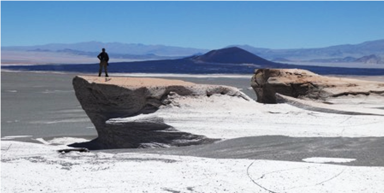
Figure 1. Yardangs of the Puna, carved into ash, surrounded by gravels. With young cinder cone.
Introduction
Wind erosion of planetary bodies yields a variety of landforms, including yardangs (wind-carved ridges), bedrock ridges, sastrugi (ridges formed in hardened snow), with many of these features covered or surrounded by gravels or sands (Fig. 1, ) [1, 2, 3].
These landforms are also found on Mars [4, 5], Titan [6] and Venus. The regular spacing seen in many of these wind-eroded landforms is postulated to have arisen naturally out of wind-sediment relationships possibly controlled by bedrock hardness [7] and sediment supply [8] more than pre-existing fracturing or river channels, though both of those have also been implicated [9].
Our ongoing field project in the Puna of Argentina involves field operations over 5-7 days using observations and simple instrumentation. Our methods are designed to measure the effects of current and past winds, rock properties, and erosive power of sands and gravels on yardang and bedrock ridge morphologies. We investigate the proposition that the simple action of wind on solid surfaces can lead to the complex, self-organized forms observed where wind is dominant and surfaces are erodible.
The Puna Field Site and Methods
The Puna desert is dominated by young deposits of volcanic ash [10], evaporites and basalt cinder cones. The high elevation means air density is lower about ~1/3 compared to sea level. On Mars, the lower air density leads to large and high dust devils, and similarly large dust devils have been observed during our field campaigns in the Puna [11]. The ash deposits are widespread, and often contain up to km-scale (mega) yardangs. The youngest and softest ignimbrite, called the Campo de Piedra Pomez (CPP) [10], contains abundant medium-sized (meter-scale), mesoyardangs. We visited this region in 2015, 2018 and 2019 (Fig. 1).
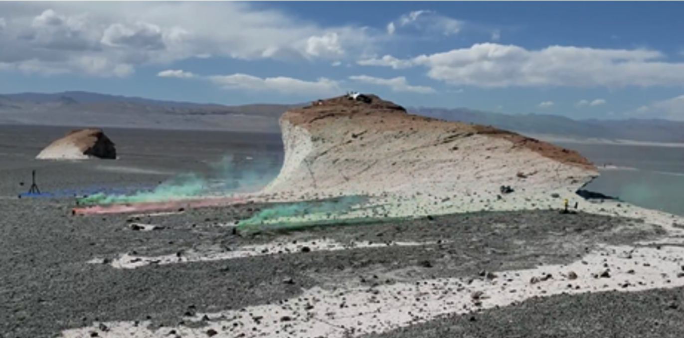
Fig. 2. Smoke released near a lone yardang, revealing sideways (secondary) winds.
We examined field relationships such as orientations of yardangs, rock hardness and layering. We observed differences in rock colors related to intrinsic composition as well as weathering over time. We recorded relative matrix/pumice hardnesses and subsequent variations in erosional properties. We measured locations and sizes of wind indicators such as dedos (protrusions protected by harder lithics) and scours. We observed the action of wind on a single yardang over the course of a 7-day field excursion with an array of small instruments including Kestrel anemometers, simple smoke candles and a camera (Fig. 2), and a tuft net [12]. We deployed two DJI Mavic drones across the main CPP field to obtain a 3 cm DEM (Fig. 3), which also reveals parameters such as length, orientation, and spacing.
Key Observations
Winds over the time we observed the lone yardang (Fig. 3) in 2019 were dominantly from a direction oblique to the yardang long axis orientation and previously observed primary winds. This secondary wind may impact yardang size and shape. Preliminary results from study of the drone DEM obtained in 2019 reveal a 1:1 width/spacing relationship, similar to other studies. This is ascribed to the steady operation of wind and erosive agents over time on a relatively uniform substrate. A similar ratio was found using a DEM for a portion of the Medusae Fossae Formation (MFF) on Mars.
A dark orange coating on the leeward sides of the yardangs [13] (Figs. 2 and 3) is not presently being eroded. They are likely older surfaces reflective of the slopes of the wind-eroded surfaces at the onset of yardang emergence.
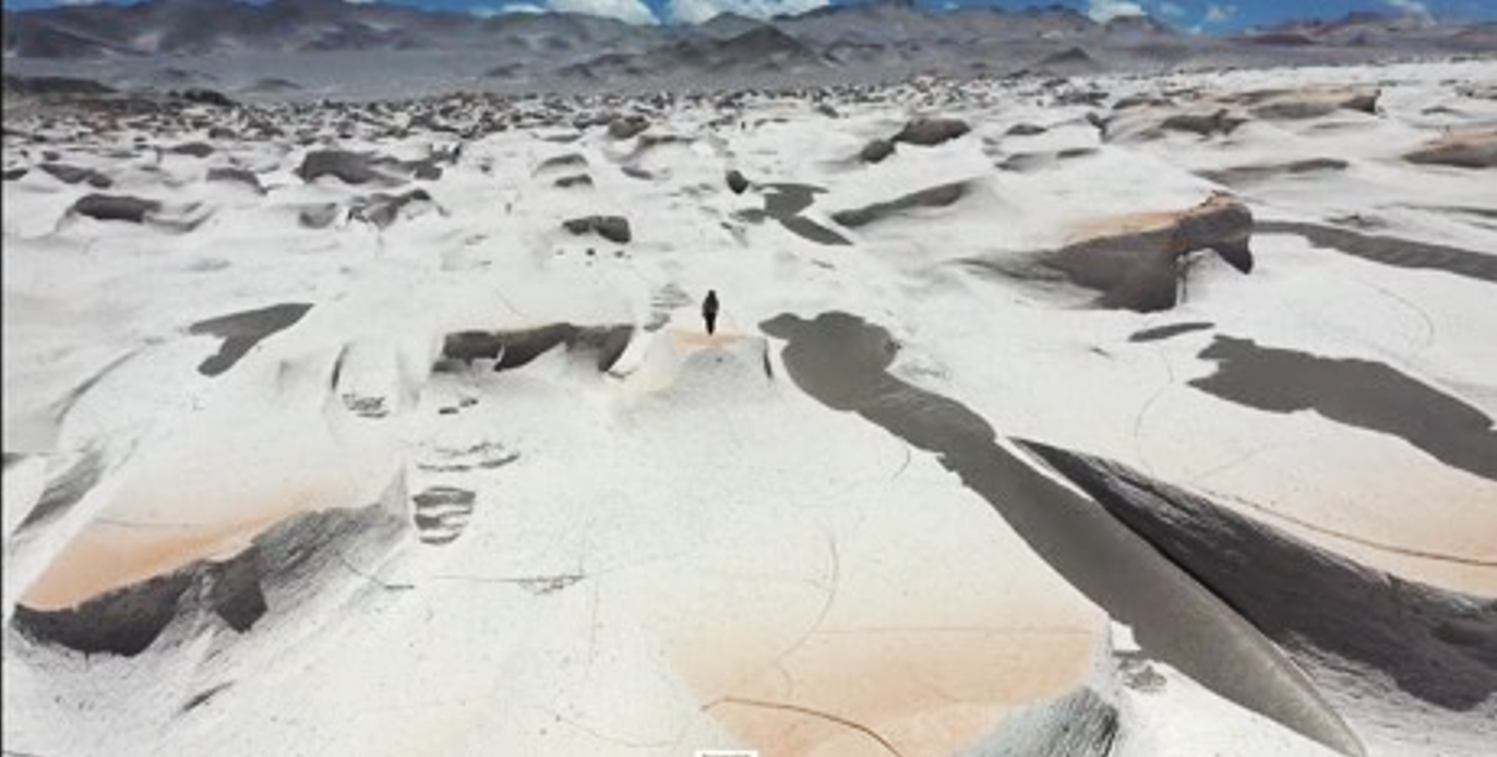
Fig. 3. Drone view of CPP yardang field (DEM images obtained from higher altitude). Person for scale.
Summary and Conclusions
Field studies in the Puna have revealed that unique landforms emerge when wind is dominant. Regularly spaced features such as yardangs or ridges emerge out of the interaction between wind and bedrock. Sizes and spacings of features likely reflect rock hardness properties. The utility of simple, reconnaissance-style field campaigns is evident in the knowledge gained through our studies of the Puna.
References
[1] Blackwelder (1934), Yardangs. GSA Bulletin 45.
[2] Ward (1979), Yardangs on Mars. JGR 8147-8166.
[3] de Silva et al. (2013) Gravel-mantled megaripples of the Puna, GSA Bulletin 125.
[4] Greeley & Iverson (1985), Threshold speeds on Venus, LPSC.
[5] Kerber et al. (2011), Origin of Medusa Fossae Formation Mars, Icarus 216.
[6] Paillou et al. (2016), Radar scattering of linear dunes and mega-yardangs on Titan, Icarus 270.
[7] de Silva S. et al. (2010), Yardangs in terrestrial ignimbrites, PSS 58.
[8] Pelletier et al. (2018), Yardang development JGR 123.
[9] Dong et al. (2012), Yardangs in the Kumtaugh, Geomorphology 139.
[10] Baez et al. (2020), Puna flow dynamics, Bull. Volc. 82.
[11] Lorenz & Radebaugh (2016), Dust devils in thin air, GRL 43.
[12] Kerber et al., in prog, Puna Yardang Observations.
[13] Aulinas et al., (2015), Rock Varnish in Dusty Regions, ESP 40.
How to cite: Radebaugh, J., Kerber, L., McDougall, D., Sevy, J., Rabinovitch, J., and Lorenz, R.: Landscapes of the Argentine Puna Reveal Conditions and Processes on Wind-Eroded Planetary Surfaces, Europlanet Science Congress 2022, Granada, Spain, 18–23 Sep 2022, EPSC2022-715, https://doi.org/10.5194/epsc2022-715, 2022.
Introduction
Sedimentary deposits developed in High-Altitude Andean Lakes (HAAL) share some extreme and environmental characteristics that made them excellent analogues for planetary geology and astrobiology research. These conditions favor the development of a diverse and abundant microbial biota that influence mineral precipitation (e.g. carbonates) and the develpoment of microbially influenced sedimentary deposits typically know as stromatolites. To recognize and differentiate stromatolites from similar laminated deposits purelly formed by chemical processes is not straightforward, and Archean stromatolites are a good example. This makes HAAL good environmental analogues to study microbe-mineral proceeses, and the associated biosignatures. The recent findings of putative marginal lacustrine and delta deposits in the Jezero crater on Mars surface highlight the potential of these systems from and astrobiology perspective. The origin and characteristics of these martian carbonates is still unknown so the evaluation potential scenarios in comparable environmental conditions may shed some light into this uncertainties.
The Laguna Negra (a high altitude lake in Catamarca Province, Argentina) is an outstaning example of HAAL where an active microbial mat system and associated carbonate deposits is well developed. These are located in the mixing zone between groundwater spring-fed pools and the main lacustrine system. The Laguna Negra is a unique natural laboratory that fulfills the environmental criteria suggested for early Earth (Archean) and Mars (Noachian) where spectrum of biotic and abiotic process can be studied improving our ability to interpret the sedimentary record on our planet and beyond.
Geological setting
The Laguna Negra is a shallow hypersaline lake where the pH of the main lake and the groundwater springs feeding the lake fluctuates between ~6 and ~8 and salinity between ~320 and ~9 ppt respectively. The mixing zone between the main lake and groundwater is oversaturated with respect to calcite and aragonite. The carbonate belt consists of oncoids, stromatolites, and laminar crusts that are spatially localized in different zones and associated to different microbial mats systems and chemical conditions. Particularly interesting are the laminar crusts, developed in a zone where no significant microbial mats has been observed, but where a diversity of morphologies and microtextures has been recorded. Although interpreted as purelly chemically precipitated, unravelling the different processes that controls this morphological varibality is still challenging.
Oncoids, Stromatolites and Laminar crusts
Oncoids represented by concentrically laminated discs, spheres, and flattened domes (cm to dm in diameter) that can coalesce to form more complex structures and are typically associated with well-stratified diatom-rich microbial mats. The external surface surface can be smooth or can show pillar-like to shrub-shaped millimeter scale protrusions and ornamentations, particularly on the side affected by wind and currents. Oncoids are partially buried and can show lateral protrusions at the sediment–water and the air–water interface. Although oncoids are sub-spherical in shape, they can show asymmetric growth (bigger below the sediment–water interface). Complex lamination is also a result of oncoid rotation, particularly by cryoturbation and bioturbation.
Although water mixing, CO2 degassing, and evaporation are particularly important to trigger carbonate precipitation the influence of microbial mats is visible in the macromorphologies (differential growth within the anoxic zone related to metabolisms that increase alkalinity) and a diverse set of microtextures some of which are interpreted as microbially influenced.
Stromatolites more localized and represented by centimeter to decimeter-scale laminated structures (up to 25 cm) that typically have a planar or laminar to columnar shape. They are observed associated with dark colored microbial mats and usually are encrusting the upper surface of oncoids. The columnar structures are usually centimeter-sized. Internal lamination is irregular, overlapping, crenulated-micritic to micro-peloidal laminae that preserve abundant organic remains. These features are suggestive of microbially influenced texture.
Laminar crusts show a patchy distribution and represented by millimeter to decimeter carbonate crusts encrusting volcanic rocks, peloidal sediments as well as organic remains. Can also develop dome-shaped morphologies showing concentric growth patterns. These concentric structures can be slightly assymetrical, showing preferential growth towards the upper half (as opposed to oncoids). Oriented and elongated structures are common (by wind-driven currents in the lake). Plates and domes can be rotated and/or coalesce to form more complex structures or more extensive platforms along the lakeshore. The surface can be smooth or show dendritic to pustular patterns or protusions as well as travertine-like microterracetes.
Isopachous regular laminane is the most common building block, as stated showing a concentric pattern but it is worth mentioning that the wind-oriented structures, in cross-section, develop more complex micro-textures (shrub-like to dendritic/micro-stromatolite microfabrics) that resemble microbially influenced structures.
Given the absence of microbial mats, and the macro-morphologies and micro-textures described (e.g., lamina regularity and degree of inheritance, lack of organic remains within the lamina), these structures have been interpreted as predominantly chemically precipitated carbonates, triggered by oversaturation related to water mixing, strong CO2 degassing, and evaporation.
Final considerations
Both, physocochemical and microbial processes can contribute to a diverse range of morphologies and carbonate microtextures and it is not easy to urvanel their relative contributions. Oncoids, stromatolites and laminar crusts show some distinctive features that suggest some of the driving controls, but also some overlapping characteristics that may be difficult to discriminate. As an example, although laminar crusts generally show (in cross section) a strong lamina regularity, a more diverse set of microtextures can be produced by the influence of advective-diffusive processes, localized scarbonate precipitation, rotation due waves, and cryo-bioturbation, thus increasing lamina complexity that can be confused with microbially influenced textures. Possible origins of the carbonates recorded at Jezero crater, for example including carbonate crusts developed over the basaltic substrate, pore-vein-filling carbonate cements, reworked carbonate material, or even stromatolite-like structures. Although chemical biosignatures (trace element distribution and isotope fractionation) are central in the tool box of astrobiologists, to recognize the putative biogenicity of these carbonates it is necessary to combine chemical analysis with the information provided by the external macro-micro morphology and the internal macro and micro microfabric, something that may not be possible when dealing with rover or image based analysis on outcrops or with sample returned to Earth, where part of the context may be lost.
How to cite: Gomez, F., Matic, M., Perez Valdenegro, P., Boidi, F., and Mlewski, C.: High-Altitude Andean Lakes as Natural Laboratories for Planetary Geology and Astrobiology Research: The Laguna Negra case (Argentina), Europlanet Science Congress 2022, Granada, Spain, 18–23 Sep 2022, EPSC2022-822, https://doi.org/10.5194/epsc2022-822, 2022.
Abstract: This work describes a new high-altitude Mars analogue site and the stratification of microbial communities with depth within lake sediments. Understanding how microbial communities at this site change with depth may give insights into the type of metabolism that may have dominated paleolake environments on early Mars and the resulting biosignatures.
Introduction: High-Altitude Andean lakes (HAALs) are poly-extreme environments which mimic many of the physiochemical conditions present on Mars during the Noachian (4.1 – 3.7 Gya) and Hesperian Mars (3.7 – 3.0 Gya)1,2. This combination of physiochemical conditions has led to HAALs being identified as natural laboratories for studying life under conditions analogous to early Earth and early Mars1,3. Present-day Mars is a cold, hyper-arid planet with surface conditions incapable of supporting liquid water in most locations. However, orbiter, rover, and lander missions have uncovered extensive hydrated mineral deposits and widespread geomorphological evidence of long-lasting fluvial and lacustrine environments, which dried up in the Hesperian4. Following the collapse of the martian magnetosphere, conditions on the surface would have become increasingly inclement. However, lake sediments may have offered refuge against desiccation, intense ultra-violet radiation (UV), large diurnal temperature fluctuations, and reduced atmospheric pressures with biosignatures potentially being preserved following lithificaytion5. For this reason, the study of analogue environments and the nascent microbiome is crucial in informing targets for biosignature detection. Despite their relevance to early Hesperian Mars, the lakes of the Argentinian Puna (a plateau between 3000 – 6000 m) remain understudied6. Here we present the geochemistry and microbial communities associated with the lake water and sediments from the previously undescribed Laguna de Antofagasta (LDA; Catamarca, Argentina, -26.111148, -67.407338) were analysed. We demonstrated that these communities change with depth, which will aid in identifying relevant metabolisms and biosignatures to inform current and future life-detection missions.
Methods: Lake water and cores (5 x 30 cm) were collected from five sample points located around the perimeter of LDA in April 2022 (Figure 1). For each microbial core, a sister core was collected for geochemical analyses (pH, temperature, and dissolved oxygen (DO) readings) to avoid contamination of microbial cores. Each core was divided evenly into an upper, middle, and bottom section before being stored under anaerobic conditions. The lake water samples were collected and filtered using 0.22 µm Sterivex filters, and all samples were transported to The Open University, UK at 4˚C. Pore and lake water were analysed using ICP-OES and IC analysis to collect bulk chemical and ionic concentrations. DNA was extracted using the XS buffer method7, and 16S rRNA gene sequencing was performed to characterise the microbial communities. In addition, Postgate B media was used during culture-dependent analysis to isolate sulphate-reducing bacteria (SRB).
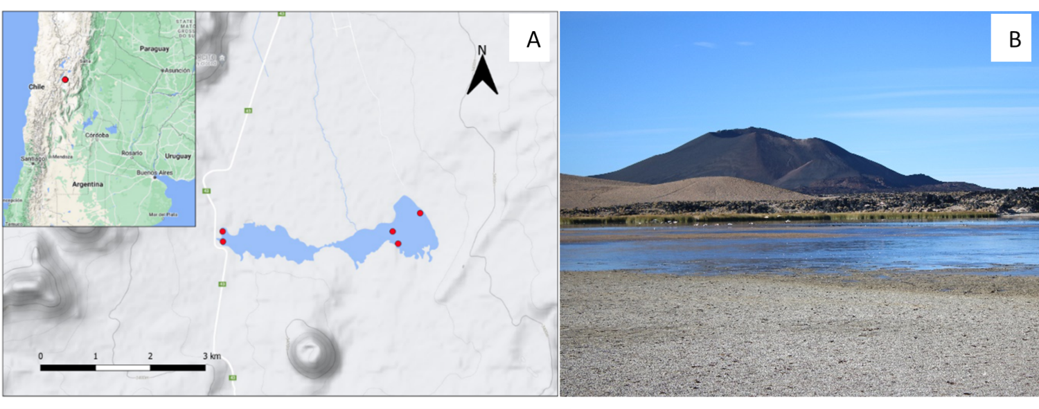
Figure 1: Laguna de Antofagasta (LDA) is situated in the Argentinian Puna in the Andes (A). LDA sits at the base of the Volcán La Alumbrera lava field, Antofagasta volcanic field, Catamarca, Argentina (Image B). Image credit: Gerardo Antonio Stoppiello.
Results: There were clear differences in physicochemical conditions as well as microbial communities between the sites. Depth correlated with temperature stability, e.g., the upper sections 0-10 cm (n=5) ranged from 2.5 – 13.0 and the bottom 20-30 cm (n=5) fluctuated between 6. 7 and 8.3˚C. pH ranged from 6.8 to 8.3 but appeared to be stable across the depth profiles (Figure 2). Microbial communities also shifted with depth; genera associated with sulfate-reduction became dominant in the bottom sections. Subsequent culture-independent analysis successfully enriched for sulfate-reducing microorganisms. Canonical Correspondence Analysis (CCA) indicated that dissolved oxygen levels, location, and pH had the greatest impact on microbial community composition.
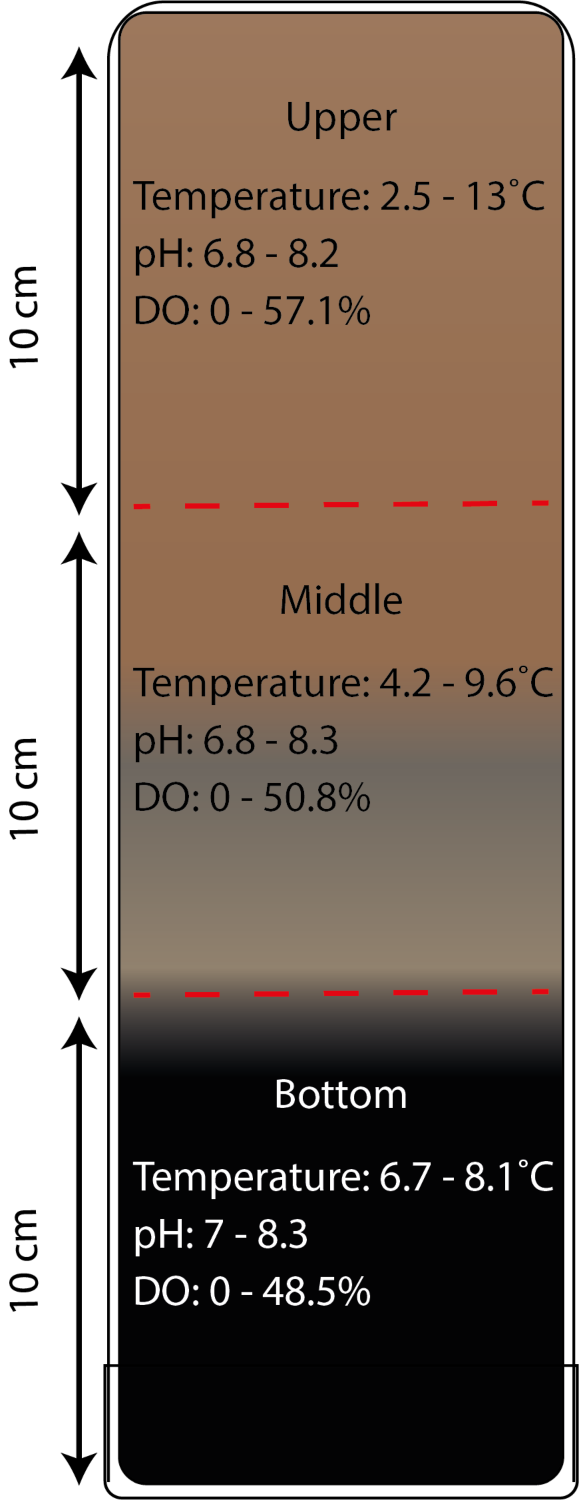
Figure 2: Cores were separated into sections before and data were collected on temperature, pH and DO.
Implications: In line with previous works6,8,9, the results from this study highlight sulfate reduction as a key metabolism within HAALs and Mars analogue environments. This is significant as biosignatures, and their preservation may be influenced by depth. This work also highlights that physical conditions in the shallow subsurface remain stable, avoiding many of the challenges presented to life by extreme UV, desiccation, and diurnal temperature fluctuation.
Future work: To identify how microbial communities may have stratified in martian paleolakes, simulation experiments will be performed. To replicate geochemical conditions, a novel simulant will be used in a column and microbial community structure will be monitored across depth and time.
References
[1] Cabrol et al. Geophys Res Biogeosciences. 2009;114(4):1–20.
[2] Farías et al. J Geophys Res Biogeosciences. 2009;114(G2):0–04.
[3] Mlewski et al. Front Microbiol. 2018;9(MAY):996.
[4] Carr & Head JW. Earth Planet Sci Lett. 2010;294(3–4):185–203.
[5] Grotzinger et al. Science (80- ). 2014;343(6169).
[6] Gomez et al. PALAIOS. 2014;29(5):233–49.
[7] Tillett & Neilan. J Phycol. 2000;36(1):251–8.
[8] Nixon et al. Astron Geophys. 2013;54(1):13–6.
[9] Westall et al. Astrobiology. 2015;15(11):998–1029.
How to cite: Tatton, B., Macey, M. C., Gomez, F., Schwenzer, S. P., Toubes-Rodrigo, M., and Olsson-Francis, K.: Scratching beneath the surface of a Mars analogue site: Microbial stratification in Laguna de Alumbrea, Europlanet Science Congress 2022, Granada, Spain, 18–23 Sep 2022, EPSC2022-1152, https://doi.org/10.5194/epsc2022-1152, 2022.
In the framework of Europlanet 2024 Research Infrastructure (RI) Transnational Access (TA) programme, from 29 September to 6 October 2021 a field campaign was conducted at the Makgadikgadi Salt Pans (Botswana) [1] with the spare units of the radiometers RDS [3] (part of MEDA meteo station [2] onboard on the NASA Mars 2020 Perseverance rover) and SIS (originally selected for ExoMars 2022 METEO package).The main goal of the campaign was to characterize the impact of dust devils on the observations made by these sensors, and so to evaluate the capabilities of this instrumentation to constrain the dust lifting activity on Mars (RDS is currently operating on Mars). For each day of the campaign, RDS and SIS were set at two different locations with the following instrumentation: 1) Two cameras to record panoramic videos; 2) A Vaisala weather station to perform measurements of pressure, wind direction and intensity, temperature and relative humidity; 3) A ZEN radiometer to measure how much light was absorbed by the dust at different wavelengths.
In this work we will present the different results obtained during this campaign for which a large number of dust devils and dust lifting events produced by wind gusts were analysed. For each dust lifting, we recorded the dust devil distance, the size, duration and direction. This information along with the videos made by the cameras, helped us to establish the amount of dust lifted by the dust devil as well as their distances from the instruments. We will also discuss the implication of our results for establishing the RDS and SIS capabilities for dust lifting characterisation on Mars.
How to cite: Toledo, D., Apéstigue, V., Arruego, I., Montoro, F., Martinez-Oter, J., Serrano, F., Yela, M., Carrasco-Blázquez, I., and Franchi, F.: Investigating dust devils on Mars through the Makadikadi Salt Pans analogue (Botswana), Europlanet Science Congress 2022, Granada, Spain, 18–23 Sep 2022, EPSC2022-485, https://doi.org/10.5194/epsc2022-485, 2022.
Stromatolites are ideal ecosystems of microbe–sediment synergy and, therefore, represent a fundamental resource for the recognition of biosignatures and investigation of astrobiological targets with regard to environment and life interactions. Even though they are one of the oldest records of life on Earth, at present, modern occurrences of stromatolites are restricted to extreme environments, such as hypersaline lakes. This work aims to characterize stromatolite features that can be used as biosignatures, seeking to understand their morphogenetic and preservation processes. Samples were collected in Lake Ashenge, a hyperalkaline high-altitude lake located in the Tigray Region of Ethiopia.
Two distinct microfacies were observed in the Lake Ashenge stromatolites: a) columnar stromatolites; and b) bulbous stromatolites. Both microfacies feature of slightly laminated microfabric composed of intercalated thicker layers of microsparite and thinner layers of calcite micrite within which exceptionally well-preserved microbial fossils including filamentous and coccoidal cyanobacteria-dominated colonies were recognized. Columnar stromatolite layers show mostly parallel or interlaced vertical arrangements of filamentous microbes which suggest different directions of water flow, demonstrating that the spatial arrangements of microbes reflect the dynamics of the environment. Bulbous structures are composed either of colonies of shrub-like filaments along their entire length and height grading into a vertical parallel arrangement at the top. This type of arrangement suggests self-sustainability of the microbial community, improving the resistance of the structures, in order to endure physical processes in the environment such as currents and wave action or predation. All samples show extracellular polymeric substances (EPS) produced by microbes normally associated with filamentous microbes. In this context, EPS may serve to support and stabilise the biofilm and contribute to the formation of columnar and bulbous structures.
Mars 2020 Perseverance rover recorded carbonate occurrences in Martian paleoenvironments from Jezero Crater which have been compared with microbialites and tufas with the potential to preserve biosignatures similar to those found in Lake Ashenge samples. Therefore, although stromatolite morphology itself configures a macroscopic biosignature which may be detected in Mars rover images, the two scales of observation (millimetres- centimetres vs micrometric) identified biosignatures in the stromatolites of Lake Ashenge could also reflect different conditions of the dynamic environment during their development. In this regard, Lake Ashenge illustrates an important modern environment for astrobiological studies and has potential analogy to ancient lacustrine environments on Mars.
How to cite: Cardoso Dorneles, V. A., Hickman-Lewis, K., Haileselasie, T., and Cavalazzi, B.: Stromatolites from extreme environment as tools for astrobiological exploration, study case of Lake Ashenge, East African Rift system, Europlanet Science Congress 2022, Granada, Spain, 18–23 Sep 2022, EPSC2022-1125, https://doi.org/10.5194/epsc2022-1125, 2022.
Introduction
Studying planetary field analog environments is a key point in order to define the physical and chemical parameters that favor life on Earth and other planets. Terrestrial hydrothermal springs have long been considered among the most significant planetary analogs searching for traces of life on Mars [1].
Hyperspectral data have been recognised to be more suitable for the detailed mapping and identification of rocks and minerals identification of land surface, especially for minerals [2].
Notwithstanding the technological advances, hyperspectral satellites are still poorly represented in spaceborne missions for Earth Exploration compared to multispectral ones. In this context, the Italian Space Agency (ASI) EO mission named PRISMA (PRecursore IperSpettrale della Missione Applicativa, [3]) offers a great opportunity to improve the knowledge about the scientific applications of spaceborne hyperspectral data.
PRISMA, launched in March 2019, includes a panchromatic and a hyperspectral camera with 239 spectral bands. Specifically, the PRISMA satellite comprises a high-spectral resolution Visible Near InfraRed (VNIR) and Short-Wave InfraRed (SWIR) imaging spectrometer, ranging 400-2500 nm, with 30 m ground sampling distance (GSD) and 5 m GSD for the panchromatic camera [4].
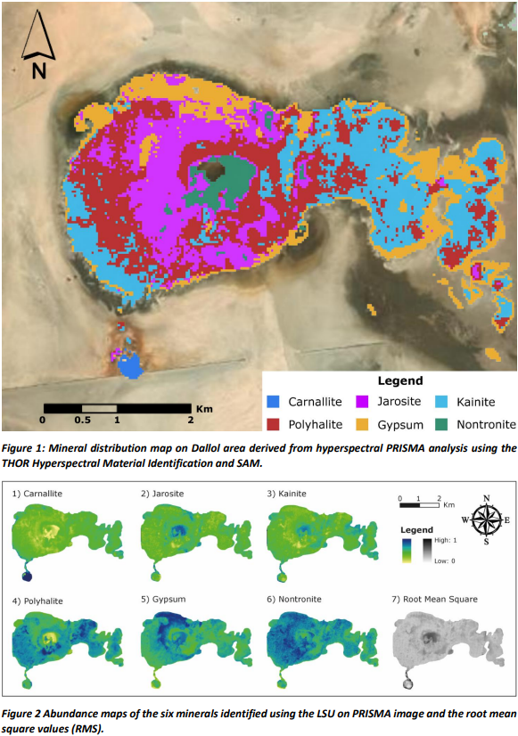
Our analysis with PRISMA images was mainly performed on an arid environment in a remote region of NE Ethiopia (Dallol; Long: 40.299351, Lat: 14.244367), representing an exceptional Mars analog due to diffuse hydrothermal alteration and the sulfate deposits evocative of past hydrothermal activity on Mars. This work aimed to obtain an identification map of minerals and their relative abundance using hyperspectral imaging to understand the potential of PRISMA as analog probe of Mars orbital instruments to detect and study possible analogs on Earth.
Study Area
Dallol is situated in the Danakil Depression, which is part of the East African Rift System. Principal geothermal features of the central crater area of Dallol are salt pillars, circular manifestations and acidic ponds. The northern and southern part is dominated by a salt dome structure and Salt pinnacles in the SW salt canyon area. The Black Mountain and the super-saline Black Lagoon, just south-southwest of Dallol, is an area of salt extrusions, geothermal manifestations and brine upflows.
One advantage of this area is that the nebulosity is generally low, in fact the image selected during the dry season has a cloud coverage percentage of less than 1%. A salt suite was deposited and re-worked by hydrothermalism in the selected site. The characteristic minerals of the area are: carbonate, halite, carnallite and bischofite, anhydrite, gypsum, native sulfur of hydrothermal origin [5; 6].
Flooding episodes from the Lake Assale to the north due to intense winds acting over the flat topography of the depression. The PRISMA SWIR Land/Water band combinations on the image selected, helped us to choose the region of interest around the Dallol area.
Operational Hyperspectral Processing
PRISMA images have three different levels of processing. Level 2C and 2D geolocated and atmospherically corrected images were used in this work and dated 21 August 2021. it is worth noticing that the images acquired on Dallol prior to the image selected for analysis had several preprocessing problems, particularly for stripe removal.
The operational hyperspectral processing is composed of three main processing steps: (1) dimensionality reduction; (2) endmember identification and (3) mineral map distribution and abundance estimation.
An unexpected result was obtained by applying an additional atmospheric correction, the Internal Average Relative Reflectance with Dark Subtraction, on the L2C image already corrected during the principal component analysis (PCA). The corrected atmospheric PCA allows better highlighting of geomorphological features.
As for step (1), since hyperspectral images are composed of hundreds of extremely correlated bands, it is possible, and indeed beneficial, to reduce the effective dimension of the input data by removing bad bands.
Step (2) was performed using the THOR Hyperspectral Material Identification (in ENVI 5.6) to identify unknown spectral signatures by comparing them with spectral libraries. This tool considers background statistics and image endmembers and can therefore provide accurate responses and spectra plots for rare or sub-pixel targets.
Finally, the Spectral Angle Mapper (SAM) and the Linear Spectral Unmixing (LSU) tools were adopted for step (3). SAM determines the spectral similarity between two spectra by calculating the angle between the spectra and treating them as vectors in a space with dimensionality equal to the number of bands. LSU is a standard technique for spectral mixture analysis that infers a set of endmembers and fractions of these, called abundances. The mineral distribution and the abundance maps are shown respectively in Fig.1 and Fig.2.
Conclusion
Six minerals have been recognised with the SAM classification from ENVI spectral library, in excellent agreement with the previous studies: carnallite, jarosite, kainite, polyhalite, gypsum and nontronite. The results confirm the mineralogical variability typical of the Dallol; in Fig.2, high mineral abundance values are shown in blue. The error calculated with the RMS is very low over the entire area of interest, except for the central zone where there are sulphur pools and therefore the presence of water does not favour this type of analysis.
To better constrain the mineralogical mapping, future work will be conducted by a field exploration campaign to collect spectral signatures to be added to the ENVI library used, which so far could not be organised due to the ongoing civil war in Dankalia.
To sum up, the study of terrestrial analogs can provide insights into the probable presence and nature of spring deposits on Mars, as well as help develop methods for classifying them from remote sensing data. PRISMA represents a valuable satellite for distinguishing not only the geometric characteristics of observed objects, but also the chemical-physical composition of the surface of the Earth.
References: [1] Walter, M.R. and Des Marais, D.J., 1993. Icarus 101:129–143 [2] Chang, C.I., 2007. John Wiley & Sons. 10.1002/0470124628 [3] Candela, L., et al. 2016. IEEE international geoscience and remote sensing symposium (IGARSS), 253-256. 10.1109/IGARSS.2016.7729057 [4] Loizzo, R., et al. 2019. IEEE (IGARSS), 4503-4506. 10.1109/IGARSS.2019.8899272 [5] Cavalazzi, B., et al. 2019. Astrobiology, 19(4), 553-578. 10.1089/AST.2018.1926 [6] López-García, J.M., et al. 2020. Frontiers in Earth Science, 7, 351. 10.3389/FEART.2019.00351
How to cite: Mancini, F., Tullo, A., Allemand, P., and Ori, G. G.: Mineral Identification and Abundance Mapping through the hyperspectral PRISMA images on the Dallol Planetary Analog, Europlanet Science Congress 2022, Granada, Spain, 18–23 Sep 2022, EPSC2022-983, https://doi.org/10.5194/epsc2022-983, 2022.
Introduction
The selected landing site of the ExoMars mission (Oxia Planum) [1] shows mineralogical and morphological evidence that it was characterized by a hydrothermal history and by a long duration of aqueous superficial activity [2; 3]. These factors are consistent with conditions favourable to life development. In this framework, we planned a field campaign in the Rio Tinto [4] area (Europlanet TA1 facility 2) where to perform a set of VIS-NIR measurements using our portable spectrometer. In addition, for each analyzed mineral/rock on-field, we collect a representative sample to be measured with the Ma_MISS instrument laboratory model.
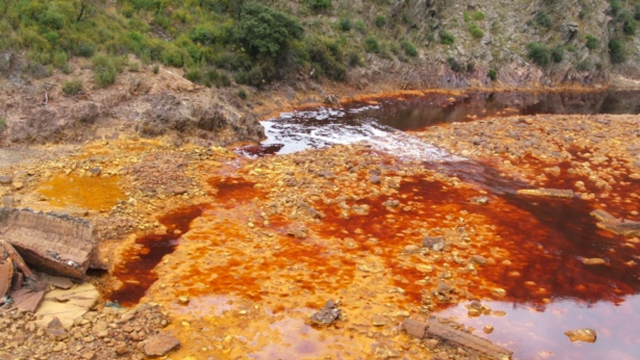
Fig.1: TA1.2 Rio Tinto, south-west Spain a very acidic 100 km river with intense red dark colour (credits F. Gomez).
The Ma_MISS instrument
Ma_MISS is the Visible and Near-Infrared miniaturized spectrometer hosted in the drill system of the ExoMars rover that will characterize the mineralogy and stratigraphy of the excavated borehole wall at different depths (<2 m) [5]. Ma_MISS with a spectral range of 0.5–2.3 μm, a spectral resolution of about 20 nm in the IR, a SNR~100, and a spatial resolution of 120 μm will accomplish the following scientific objectives: (1) determine the composition of the subsurface materials; (2) map the distribution of the subsurface H2O and hydrated phases; (3) characterize important optical and physical properties of the materials (e.g., grain size); (4) produce a stratigraphic column that will provide information on the subsurface geology. Ma_MISS will operate periodically during pauses in drilling activity and will produce hyperspectral images of the drill’s borehole.
Field activity
During the field campaign, we perform a set of VIS-NIR (0.35 – 2.5 μm) measurements using our ASD FieldSpec4 portable spectrometer on biosignatures-bearing rocks and acidic alteration products. For each selected lithotype we collect several reflectance spectra using solar light as the light source and a 99% Spectralon target as a reference in the VIS-NIR range, with particular attention to those that hypothetically host organic matter in the form of bacterial communities. In addition, for each measured mineral/rock we collect a representative sample to be used for the laboratory measurements with the Ma_MISS laboratory model. With this setup, it is possible to perform measurements with samples in different configurations (powders, slabs, or holed rock blocks); hence, we collect samples with different specific dimensions. In the case of incoherent sediments/salts, we sample a minimum amount of 20-30 g. On the contrary, in the case of coherent samples, we collect blocks with a maximum size of 10x10x10 cm, which are the optimal dimensions useful for performing the drilling operations and in-hole measurements with the DAVIS setup [6,7]. For each collected sample, we record the following data at the time of collection: imagery of the context and the sampling site with a reference scale, the three-dimensional orientation of the sample, and the geographic coordinates at the collection point using a GNSS dual-frequency GPS. Every sample is sealed in a specific container to avoid any contamination [8]. The samples’ metadata are registered in the System for Earth Samples Registration (SESAR) for long-term archival of the physical samples which can be retrieved from a unique ISGN code (isgn.org) for referencing in this and future projects.
Laboratory activity
The collected samples were measured with the DAVIS (Drill for Analogues and Visible-Infrared Spectrometer) setup at the INAF-IAPS laboratories. This laboratory facility is constituted by a drilling tool that reproduces the ExoMars Drill functionality (Laboratory Drill, LD [6]) and by a measurement tool, reproducing Ma_MISS optical characteristics (Ma_MISS Optical Tool, MOT [7]). Consisting of spare elements of the flight instrument, the DAVIS setup can be considered an instrument completely comparable to the one that will investigate the Martian subsurface. For this reason, the measurements on the collected samples become very important for instrument characterization and future data interpretation. The collected sample blocks are drilled to obtain a hole with the same characteristics as those that the ExoMars drill will do on Mars. Finally, we perform a series of in-hole spectral scans to characterize the chemical-physical properties of the collected samples. The data collected on-field and in the laboratory are analyzed and compared to reconstruct the composition of the analyzed samples. We will focus our efforts on any spectral signature related to the presence of biomarkers in the collected data since we know that the Ma_MISS tool can aid in detecting organics [9] in the Martian subsoil, which is one of the main scientific objectives of the ExoMars mission.
Conclusions
In this work, we describe the procedures followed during our geological field analysis campaign in the Rio Tinto area. This geologically/biologically well-documented site with its rock/water/biology interaction represents an ideal open-air laboratory where to collect spectral data and samples useful for testing the ExoMars/Ma_MISS spectrometer. The scientific results obtained by this and previous works made with other drilling equipment [10] and with other scientific instruments [11] confirm that this type of activity in the Rio Tinto area site is important for enriching the scientific community's grasp on the Martian environment and for obtaining key information on the mineralogical and geochemical evolution of the Martian surface/subsurface. In addition, this work provides crucial preparation for the exploitation and interpretation of the scientific data that the Ma_MISS instrument will supply during the active phase of the mission. This activity is also useful for defining the priorities of the astrobiological objectives on the ground.
Acknowledgements
This work is supported by the Italian Space Agency grant ASI-INAF n. 2017-412-H.0. Ma_MISS is funded by ASI and INAF. Europlanet 2024 RI has received funding from the European Union’s Horizon 2020 research and innovation programme under grant agreement No 871149.
References
[1]Vago, J.L. et al. (2017) Astrobiology; [2]Mandon, L. et al. (2021) Astrobiology; [3]Quantin-Nataf, C. et al. (2021) Astrobiology; [4]Amils, R. et al. (2014) Life; [5]De Sanctis, M.C. et al. (2017) Astrobiology; [6]Rossi, L. et al. (2022) 53rd LPSC #1353; [7]De Angelis, S. et al. 53rd LPSC (2022) #1796; [8]Cockell, C.S., et al. (2019) Space Sci Rev. [9]Ferrari, M. et al. (2020), EPSC2020-348; [10]Bonaccorsi, R. et al (2008) Astrobiology; [11]Gomez, F. et al., (2011) Int. J. Astrobiology.
How to cite: Ferrari, M., De Angelis, S., Frigeri, A., De Sanctis, M. C., Altieri, F., Gomez, F., Ammannito, E., Costa, N., Rossi, L., and Formisano, M.: In-situ measurement and sampling of Martian analogues in the Rio Tinto area in support of the Ma_MISS scientific activity, Europlanet Science Congress 2022, Granada, Spain, 18–23 Sep 2022, EPSC2022-153, https://doi.org/10.5194/epsc2022-153, 2022.
These structures are easily recognizable from the surface through the presence of skylights and roof collapses aligned in pit-chains, tracing the path of the underground conduit (Fig. 1). Analogous aligned collapses were seen on the surfaces of Mars and the Moon [2]. Thus, the great interest in studying large terrestrial lava tube systems is largely driven by their analogy with their extra-terrestrial equivalents.
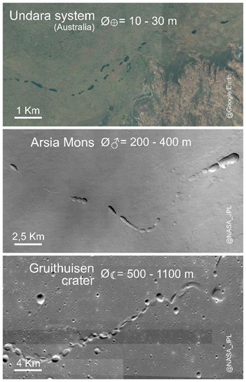
Figure 1: Comparison of lava tubes from different rocky bodies of the Solar System. From the left: Earth (Undara system, Australia), Mars (Arsia Mons region) and the Moon (Gruithuisen crater).
The main difference between structures of different planetary bodies are due to intrinsic physical characters of the parental body and above all gravity. Indeed, a weaker gravity (as in the case of Mars and the Moon) results in higher effusion rates and, thus, larger lava flows and tubes (Fig. 1). This has led to pyroducts which are two or three orders of magnitude smaller in diameter on Earth (10 - 30 m) than on Mars (250 - 400 m) and the Moon (500 - 1100 m) [5]. Despite this different scaling, the largest lava tubes on Earth are considered to be very useful analogues to their extra-terrestrial counterparts.
A clear understanding of how large pyroducts form and evolve remains elusive, even on Earth. Within this context, our work aims to identify the processes that shaped the formation of terrestrial lava tubes. Among the most studied pyroducts, the La Corona system (Lanzarote, Canary Islands, Spain) stends out for its geological context within the Canary Island Seamount Province (CISP) on which long-term and spatially focused volcanic activity developed over a poorly mobile tectonic plate. During the last 30 Ma, the absolute motion of the African plate has been nearly stationary (less than 20 mm/yr) [3]. This environment identifies the Canaries as one of the best terrestrial analogues of the Martian one-shell plate volcanism [4], and the impressive dimensions of La Corona lava tube (~9.7 km of total cave development, and a width reaching up to ~28 m for some of its sections) make it one of the most suitable lava tube for interplanetary analogies [6].
In order to understand the origin, evolution and degradation of the La Corona pyroduct, we have carried out a study of the satellite images of the northern region of Lanzarote, followed by field exploration of inner portions of the La Corona lava tube and adjacent areas.
Combining terrestrial laser scanner (TLS) technology with field observations and geochemical analyses of the pre-existing lava enabled us to reconstruct the three-dimensional geometry of the lava tube system, the subsurface horizon through which it starts developing, and the volcanic series into which the pyroduct carved its path.
What makes this inflated lava tube so interesting is the presence, between the flows the tube has crossed, of a red pyroclastic layer, resulting from the initial Strombolian activity of La Corona vent [7]. This weak layer of pyroclastic material played a major role in the development of the lava tube (Fig. 2), facilitating the emplacement of the inflation process and the excavation that followed [6]. By analogy, similar geological settings could be favourable for the formation of lava tubes on rocky bodies like Mars and the Moon since the volcanic sequences on such bodies can be frequently interleaved by either weak pyroclastic and regolith layers.
Other influent parameters controlling erosion include slope variations of the paleo-surface (i.e., knickpoints), and the lava physical properties, both to be well investigated on terrestrial analogues to understand their role even on planetary contexts.
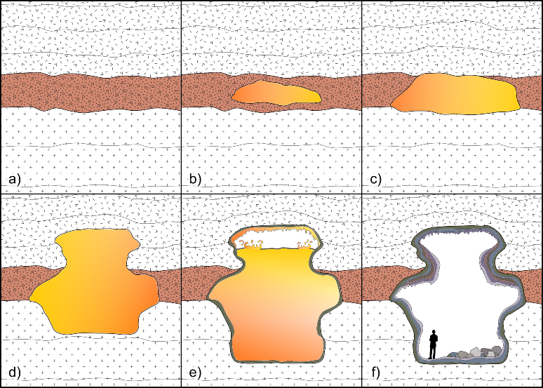
Figure 2: Thermo-mechanical erosional stages of the lava tube in cross-sections. a) The primary effusive phase has covered the pyroclastic deposit of the initial Strombolian event; b) the inception of the tube by inflation starts exploiting the pyroclastic layer; c-d-e) progressive erosion and enlargement of the tunnel; f) post-cooling phase. On the walls are visible different layers of linings and flow ledges. The floor is covered by blocks and debris, remnants of the breaking down of the ceiling and lining walls.
References
[1] Coan, T. (1844). Missionary Herald. [2] Haruyama, J. et al. (2012) Trans. JAPAN Soc. Aeronaut. Sp. Sci. Aerosp. Technol. JAPAN 10. [3] Gaina, C. et al. (2013). Tectonophysics, 604, 4-25. [4] Meyzen, C. M., et al. (2015) Geol. Soc. London, Spec. Publ. 401. [5] Sauro et al. (2020) Earth-Science Rev. [6] Tomasi, I. et al. (pending) JGR – Solid Earth. [6] Carracedo, J. C. et al. (2003) Estud. Geol. 59.
How to cite: Tomasi, I., Massironi, M., Meyzen, C. M., Sauro, F., Pozzobon, R., Penasa, L., Santagata, T., Martìnez-Frìas, J., and Mateo Mederos, E.: Large size lava tubes as planetary analogues: the case of La Corona (Lanzarote, Canary Islands), Europlanet Science Congress 2022, Granada, Spain, 18–23 Sep 2022, EPSC2022-1003, https://doi.org/10.5194/epsc2022-1003, 2022.
Lava tubes on Mars hold exciting potential for the preservation of biosignatures, which may survive on geological timescales in these isolated, stable environments. To support the development of future astrobiological mission concepts, we turn to terrestrial lava tubes, host to a variety of microbial communities and secondary minerals. Following a multidisciplinary sampling protocol, we retrieved biological, molecular, and mineralogical data from several lava tubes in Iceland. We report on blue-colored copper-rich secondary minerals and their associated bacterial communities using a multi-method approach, and an amalgam of 16S rRNA gene sequencing, Raman spectroscopy, scanning electron microscopy, and energy-dispersive X-ray spectroscopy data sets. We found numerous bacterial genera known for their high metal resistance and ability to survive in low-nutrient environments. Both are characteristics to be expected for any potential life in Martian lava tubes, and should be considered when checking for contaminants in Mars mission preparations. Associated with the microbial mats, we identified several types of copper-rich secondary minerals, indicating localized copper enrichments in the groundwater, possibly stemming from overlying ash deposits and nearby hyaloclastite formations. Molecular analysis revealed carotenoid signals preserved within the copper speleothems. If found in Martian lava tubes, blue copper-rich mineral precipitates would be deserving of astrobiological investigation, as they have potential to preserve biosignatures and harbor life.
How to cite: Kopacz, N., Csuka, J., Baqué, M., Iakubivskyi, I., Guðlaugardóttir, H., Klarenberg, I. J., Ahmed, M., Zetterlind, A., Singh, A., ten Kate, I. L., Hellebrand, E., Stockwell, B. R., Stefánsson, Á. B., Vilhelmsson, O., Neubeck, A., Anna Schnürer, A., and Geppert, W.: Blue biotopes in Icelandic lava tubes: analog environments for subsurface life on Mars, Europlanet Science Congress 2022, Granada, Spain, 18–23 Sep 2022, EPSC2022-558, https://doi.org/10.5194/epsc2022-558, 2022.
While glacial systems are well established as susceptible environments to climatic alterations, they also offer a set of extreme conditions that are optimal for habitability studies and to interrogate the limits of life. In these settings, indigenous microorganisms must endure a prolonged exposure to cold temperatures and to background radiation for geological timescales. Therefore, glaciers and the surrounding cryo-environments (permafrost, glacial lakes or melting streams) arise as relevant scenarios to examine the development of functional microbial cryo-ecosystems and may have implications in the search for past or extant life in icy worlds beyond Earth.
Among the multiple perspectives from which thermal susceptibility can be measured, lacustrine systems effectively archive paleoenvironmental information due to their high sedimentation rates and organic matter content. Thus, polar lakes exposed to glacial or periglacial conditions are expected to contain a thriving biology that responds to not only a continuously oscillating level of nutrients, but also to a set of extreme conditions (subzero temperatures and high UV flux) that may geochemically and environmentally resemble potentially habitable locations of the Solar System such as the Martian poles or the subglacial water bodies enclosed in the satellites Europa and Enceladus.
The permanent ice sheet in Greenland represents a possible analog of the icy worlds, constituting an important long-term repository of psychrophilic microorganisms. Around it, different geological formations such as glacial lakes, permafrost or further peat soils represent a diverse degree of geobiological succession upon the influence (and retreat) of the ice sheet due to its thermal destabilization. Investigating molecular and isotopic lipid biomarkers of microorganisms inhabiting different cryo-ecosystems at and around the Greenland glacial structures may help obtain insights as of the type of life that could potentially arise on analogous extraterrestrial cold environments (ice sheet). Moreover, it could give clues on cryo-ecosystem evolutionary processes (biological succession) that are triggered when the ice cover retreats and gets exposed to the atmosphere (giving rise to glacier-melting streams, bedrock-erosion sediments, lake sediments and glacial soils). In particular, the focus of our studies is set on exploring the organic geochemistry of sediments in polar lakes representing nearby glacier-influenced ecosystems (glacial lakes) versus meteoric lakes representing longer time-exposed and further developed lacustrine and soil ecosystems (non-glacial lake).
Here, we present preliminary results of a biogeochemical study in a meltwater and meteoric lake system within the Kangerlussuaq region by the West coast of Greenland, representing an advanced state of succession in the thermal exposition gradient of the territory. We employed molecular (lipid biomarkers) and compound-specific isotopic analyses to define ecological (microbial community structure) and metabolic (carbon assimilation-related) fingerprints in this (relatively) long exposed glacial system compared to more recently exposed lakes in Greenland. Ultimately, we aim to learn about the microbial strategies to adapt to the ever-changing conditions caused by glacier retreat at the aforementioned molecular and isotopic level. The ubiquity of lipids as basic cellular membrane compounds and their recalcitrant hydrocarbon skeletons render these molecules a solid biomarker candidacy for the study of organic matter and habitability in the context of ecology and astrobiology, respectively.
Overall, the combination of lipid biomarker analysis and carbon isotopic studies on sediment samples of polar lakes supports the establishment of reliable lipid biomarkers in a cold, extreme environment, as well as their potential psychrophilic biosource. At the same time, determining the lipid content and their metabolic biosynthetic pathways builds a comprehensive perspective on the extent of the influence of environmental changes on the organic matter content in climatically susceptible environments.
How to cite: de Lucía Finkel, P., Carrizo, D., Parro, V., and Sánchez-García, L.: Ecological paleo-reconstruction of polar lakes in Greenland based on molecular and isotopic analysis of lipid biomarkers, Europlanet Science Congress 2022, Granada, Spain, 18–23 Sep 2022, EPSC2022-938, https://doi.org/10.5194/epsc2022-938, 2022.
Phosphorus is a key element in all forms of life. However, P on Earth is scarce as it is locked in low solubility phosphate minerals, raising the fundamental and long-lasting question about where early life got its P supply. Hydrothermal vents or extremely acidic hot springs have been commonly investigated as favourable environments for the emergence and evolution of primitive organisms. More recently, carbonate-rich lakes have been proposed to concentrate enough dissolved P to favour the formation of life (Toner & Catling 2020), thus providing a plausible solution to phosphate supply.
In this study, we investigate P recycling and bioavailability in carbonate and iron-rich Archaean deposits (~3 Ga) to expand our understanding of the possible origin of life on Earth, and to test the astrobiological implications on other terrestrial planets, like Mars. Unlike Earth, carbonates on Mars are scarce (Bultel et al., 2019). Interestingly, the Jezero crater, where the rover Perseverance is currently searching for sights of ancient life, is one of the few locations showing abundant carbonates on Mars (Horgan et al., 2020). Thus, these Archaean deposits serve as a Jezero crater analogue for early life on Earth.
Phosphorus recycling is driven by the redox chemistry of the water column. Accordingly, this study will explore the prevailing redox conditions (oxic-dysoxic, ferruginous and/or euxinic), and their fluctuation, in the water column at the time of deposition. This is important because ferruginous conditions may promote P fixation in the sediments due to the drawdown of iron particles and organic matter. By contrast, euxinic conditions may enhance the flux of bioavailable P in the water column due to the degradation of organic matter and the dissolution of Fe oxides, both effective P carriers to the sediment.
To better approach P bioavailability in these carbonate and iron-rich deposits, combined geochemical analyses and biogeochemical modelling are used. On one hand, coupling iron and phosphorus speciation geochemical techniques allow for the sequential extraction of different forms of Fe and P and serve to quantify their concentrations (Poulton & Canfield, 2005; Thompson et al., 2019). On the other hand, biogeochemical models allow for the understanding of Ca-Fe-S-P interactions within variable redox conditions.
Iron speciation results will determine whether the studied carbonates were deposited under euxinic or ferruginous conditions, relative to total iron (FeT), and will track the redox evolution upward stratigraphy. Phosphorus speciation results will quantify different operationally defined P sedimentary pools, including iron associated (PFe), authigenic (Pauth), detrital (Pdet), organic (Porg) and total (PT). Subsequently, Fe and P results will be modeled to address two fundamental research questions: a) shifts from ferruginous to euxinic conditions promoted the accumulation of dissolved phosphate, and b) iron reduction (microbial or abiotic) favoured the increase of alkalinity, contributing to carbonate precipitation.
Paleoenvironmental reconstructions of early Earth play a key role in unravelling the co-evolution of life and the Earth system. Our understanding of the biogeochemical evolution of the P cycle during the Archean may shed light on whether carbonates on early Mars could have accumulated enough dissolved P to become favourable environments for the emergence and evolution of life.
References:
Bultel, B. et al. (2019). Journal of Geophysical Research: Planets, 124, 989–1007.
Horgan, B. et al. (2020). Icarus 339, 113526.
Poulton, S. W. & Canfield, D. E. (2005). Chemical Geology, 214, 209–221.
Thompson, J. et al. (2019). Chemical Geology, 524, 383–393.
Toner, J. D. & Catling, D. C. A. (2020). PNAS. 117, 883–888.
How to cite: Cañadas Blasco, F. and G. Fairén, A.: Phosphorus Cycling and Bioavailability in Archean Carbonates: Analogues for Martian Paleoenvironments, Europlanet Science Congress 2022, Granada, Spain, 18–23 Sep 2022, EPSC2022-311, https://doi.org/10.5194/epsc2022-311, 2022.
Introduction: Sedimentary volcanism if ever operated on Mars would be a potentially interesting target for investigation by future landing missions for understanding volatile and sediment migration in the crust and the potential for astrobiology [e.g., 1, 2, 3, 4]. In order to support the argument for conducting such missions, deeper understating of the mud volcanism and their biological environment in terrestrial analogs are desired. Here, we report about our research activities on various mud volcanism types (e.g., large and small scales, low and high temperatures, active and fossil) from terrestrial analog sites (one site in Azerbaijan and three sites in Japan). The investigations are conducted in extensive collaborations with a number of other research groups.
Ongoing studies at terrestrial analog sites: We list here terrestrial analog sites where we have been studying to provide insights on geological (physical and chemical) processes and astrobiological implications of sedimentary volcanism that may have operated on Mars.
Azerbaijan: This country along the Caspian Sea hosts some of the best and largest examples of mud volcanoes on Earth [5, 6]. There is a great variety of MV morphologies observed in the area (Fig. 1) and these MVs have been utilized as terrestrial analogs for identifying possible SVs on Mars [e.g., 7]. However, the genetic factors controlling the formation of MVs have not been well understood and the approach in physical volcanology would be useful for revealing their formation mechanisms. A systematic morphological/morphometric survey of MVs in the world including those in Azerbaijan has been considered [8].
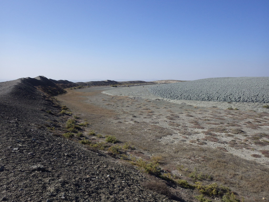
Fig. 1. Summit crater of Bozdag-Guzdek, an approx. 3-km wide mud volcano in Azerbaijan [7]. The grey-color material on the right represents the front of a mud flow erupted recently.
The Goshogake mud volcano field: This MV field in northern Japan is characterized by high-temperature (33–98 °C), acidic (pH 2.44–2.94) fluids with the influence of nearby magmatic volcanism (Fig. 2) [9, 10]. The presence of high-temperature silica polymorphs and/or microcrystalline opals, and an amorphous form of silica in the mineralogy indicates that the mud volcano system likely involves conditions and processes such as high temperature, hydrothermal circulation, dehydration reaction at certain depths underneath the Goshogake mud volcano field. The emitted gas phase includes CO2 and hydrocarbons such as methane, and it is considered that at least part of the erupted mud has a sedimentary origin. Beside characterization of the geological properties of the field, we are in the process of evaluating possible biomarkers within the mud fluids [11].
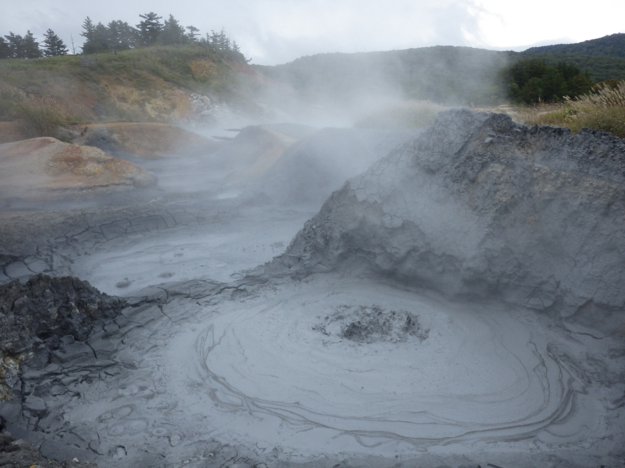
Fig. 2. Mud pots spewing hot and acidic fluids together with carbon dioxide and methane gasses in the Goshogake mud volcano field, northern Japan [9, 10].
Mud volcano vents in Tokamachi: There are MV vents distributed in the area of Tokamachi, central Japan. There are four vent sites of particular interest that are emitting methane gas at high concentration levels (Fig. 3). The total methane emission was estimated to be least 20 ton/year, of which more than half was from invisible seepage surrounding the MV vents [12]. The mud is derived from a deep subsurface deposit of marine sedimentary origin. Our microbiological investigation of the MV fluids recently characterized a methane-related ecology associated with these on-land MV vents in a sedimentary setting, which can be applicable to Mars analogs [13].
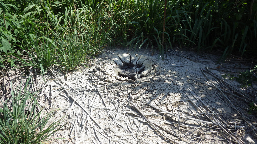
Fig. 3. This vent in Tokamachi, central Japan is emitting mud and methane gas [12, 13].
Fossilized MVs in Wakayama: There are field sites along the coasts of Kii Peninsula, western Japan (Wakayama Prefecture), where ancient mud volcanism is preserved and exposed in sedimentary sequences [14]. Here, coarse-grained shallow marine sediment sequences of the Miocene upper Tanabe Group and Kumano Group are intruded into by the underlying fine-grained sediment. The intruding mudstone deposits exhibit diverse types of stratigraphic features: mud dikes intruding into overlying layers (Fig. 4), diapirs in contact with surrounding strata. Fine-grained sedimentary materials have the potential to preserve biosignatures [15]. Thus, our ongoing investigations include search for biomarkers in the preserved mud dykes or diapirs [11], which is likely to shed light on the similar study for future landing missions in purported mud volcanoes that are now extinct.
Fig. 4. A mud dike intruding into the overlying layers. Wakayama, western Japan [14].
References: [1] Komatsu G. et al. (2014) LPSC 45th, Abstract #1085. [2] Oehler D. Z. and Allen C. A. (2012) SEPM Sp. Pub., 102, 183–194. [3] Dohm J. M. et al. (2011) In: Analogs for Planetary Exploration, GSA-SP 483, p. 317–347. [4] Wilhelm M. B. (2019) AGU, Abstract #P41C-3447. [5] Aliyev Ad. A. et al. (2009) Catalogue of mud volcanoes eruptions of Azerbaijan (1810-2007), Nafta-Press, 106 p. [6] Guliyev I. S. and Feizullayev A. A. (1997) All about mud volcanoes, Nafta Press, 52 p. [7] Komatsu G. et al. (2016) Icarus, 268, 56-75. [8] Oppo D. et al. (2020) LPSC 51th, Abstract #1041. [9] Komatsu G. et al. (2019) Geomorphology, 329, 32-45. [10] Komatsu G. (2019) Science Trends, https://sciencetrends.com/where-mud-meets-magma/. [11] Ishimaru R. et al., in preparation. [12] Etiope G. et al. (2011) Appl. Geochem., 26(3), 348-59. [13] Miyake N. et al., in submission. [14] Komatsu G. et al. (2019) LPSC 50th, Abstract #1149. [15] Komatsu G. and Ori G. G. (2000) PSS, 48/11, 1043–1052.
How to cite: Komatsu, G., Ishimaru, R., Miyake, N., and Matsui, T.: Terrestrial analog studies of sedimentary volcanism: Application to Mars science and missions, Europlanet Science Congress 2022, Granada, Spain, 18–23 Sep 2022, EPSC2022-468, https://doi.org/10.5194/epsc2022-468, 2022.
The mid-latitudes of Mars host a large amount of buried ice deposits [1], which bear a record on the very Late Amazonian climate evolution (~107 to 108 yr.) [2] and are a possible resource for future exploration [3]. The reconstruction of the history of these ice reservoirs and the characterization of their current state is critical to enable putting constraints on the interplay between climate change, volatile migration and landform evolution. Examination of terrestrial analogs can help to identify similarities and – equally important – differences between the response of buried ice on Mars and Earth to changing environmental parameters. Here we report on our long-term investigations of an ice-cored moraine on Svalbard, a proxy for mid-latitude debris-covered glacier on Mars [4].
Our study area is an ice-cored lateral moraine of Kongsvegen glacier on the southern shore of Kongsforden in NW Spitsbergen (Svalbard). This site is subject to rapid degradation by melting and redistribution of surficial sediment, e.g., by thaw slumps and debris flows [5]. We couple multi-year fieldwork with repeat remote-sensing observations. Fieldwork includes DGPS-supported monitoring of surface changes by several imaging methods comparisons to environmental data (e.g., [6]). In 2008, a flight campaign with HRSC-AX (an airborne version of DLR’s High Resolution Stereo Camera on Mars Express) provided orthoimages (20 cm/px) and a Digital Elevation Model (DEM; 50 cm ground sampling distance, GSD) [7]. In 2020 a repeat campaign with DLR’s MACS (Modular Airborne Camera System) achieved ground pixel sizes between 5 cm and 10 cm for RGB images, and 10 cm to 15 cm for NIR images. The associated DEM has the same resolution [8]. MACS also acquires TIR data,which we use to identify regions with anomalous temperatures (e.g., exposed ice). We use for detailed mapping of ice-rich viscous flow features on Mars [9]. This study focuses on the Nereidum Montes area in the northern part of the Argyre basin. Image analysis, mapping of landforms and documentation of results were carried out using the QGIS software.
A difference DEM was generated to determine the elevation differences (i.e. volume changes) on the ice-cored moraine between 2008 and 2020. Hillshade layers were created for each dataset to facilitate quick visual identification of morphological changes. Slump scars were digitized in 2008 and 2020 on orthoimages and hillshade views, and prominent slumps of 2020 (most recent, visible and best preserved) have been geomorphologically mapped with a focus on buried dead ice, collapsed sediment, and the relative activity of mud flows. Image analysis and mapping of Martian landforms is currently ongoing.
There are 4 areas of major activity within the ice-cored moraine (Fig.1.a) highlighted by the four red boxes b, c, d and e, with more than 10m of elevation losses. There are many areas showing a neutral balance in terms of topographic evolution (white pixels). Hillshade layers from 2008 (Fig.1.f) and 2020 (Fig.1.g) correspond to the area of box d and show that significant changes have occurred in 12 years, indicating a massive degradation of ice-cored moraine in the last decade. This also demonstrates that the general trend is towards a heterogenous loss of material. The slump scars appear to be concentrated in the same areas described above. In 2008, 85 scars were counted against 157 scars in 2020, i.e. almost twice as many. It also appears that the 2020 scars are following the outlines of high activity areas while the 2008 scars are within these areas.
Regarding the detailed mapping of slumps, the area corresponding to the buried dead ice, mapped with the TIR channel, can vary in shape and size depending on the shape of headscarp and the other units, i.e. the collapsed sediments and the mudflows (Fig.2.b,d). The collapsed sediments are washed away by the mudflows. The mudflow seems more active near the previously exposed dead ice. Therefore, the degradation of ice-cored moraines takes place mainly through the melting of the ice, which leads to mass wasting and rapid degradation. As Mars does not have the same climatic conditions, it is interesting to see whether the same landforms can be found on it at a very local scale.
The Mars case study displays gullies, arcuate ridges with small gullies superposed on their slopes, flow features and also possible sublimation features such as pitted terrain, broad pits, and lineated patterned ground (Fig.3.b). The area is also filled with washboard terrain which is only found at steep slopes, above the lobate flow feature. It is marked by a close alternation of closely-spaced scarps which are parallel to the contour lines (possible evidence for paraglacial sacking [10]). Tension cracks are also found at the ridges and parallel to gully headscarps indicating recent activity. These tension cracks may be similar to headscarp retreats on backwasting processes on ice-cored moraines (Fig.3.d). The ice-cored ridge or arcuate ridge may still undergo degradation. The first results show that the degradation processes are rather related to potential ice sublimation and that signs of melting ice, if they exist on Mars, are not strongly encountered, which is consistent with the studies on very Late Amazonian climate evolution.
References
[1] Levy, J. S. et al. (2014), J. Geophys. Res. Planets, 119, 2188– 2196. [2] Bramson, A. et al. (2021), Bull. Amer. Astron. Soc., 53(4), e-id. 115. [3] Putzig, N. et al. (2022) LPSC 53, #2443. [4] Petersen,E. et al. (2017) LPSC 48, #2966. [5] Bennett, M. et al. (2000) Geomorphology, 35, 21-40. [6] Boike, J. et al. (2018), Earth Syst. Sci. Data, 10, 355–390. [7] Hauber, E. et al. (2011), Geological Society of America, 483, 177–201. [8] DLR - Institut für Optische - Sensorsysteme, (2020). [9] Souness, C. and Hubbard, B. (2012), Progress in Phys. Geog. 36(2), 238-261. [10] Jawin, E. R. et al. (2018), Icarus, 309, 187-206.
How to cite: Desjardins, M., Hauber, E., Bucher, T., Geßner, M., Hiesinger, H., Schmedemann, N., Johnsson, A., Ellermann, F., Sassenroth, C., Brauchle, J., Conway, S., and Noblet, A.: Degradation processes on ice-cored moraines on Svalbard: a terrestrial analog for Mars, Europlanet Science Congress 2022, Granada, Spain, 18–23 Sep 2022, EPSC2022-1035, https://doi.org/10.5194/epsc2022-1035, 2022.
Sublimation combined with wind: Volatiles (N2, CH4, CO2, H20, NH3) are very common in the solar system (Fig 1). The average pressure and temperature conditions at the surface of many bodies suggest that volatile ices are stable and we thus expect that solid bedforms may form on these surfaces by either sublimation and/or condensation. These mass transfers between ice and overlying atmospheres are already known as landforms-shaping processes at different scales. These processes are very effective on the Martian North Polar Cap [2], whose spirals of the MNPC are known to be the result of sublimation on one side and condensation on the other [3-4], and as Pluto, where the Bladed Terrain Deposits are associated with sublimation of N2 and condensation of CH4 [5].
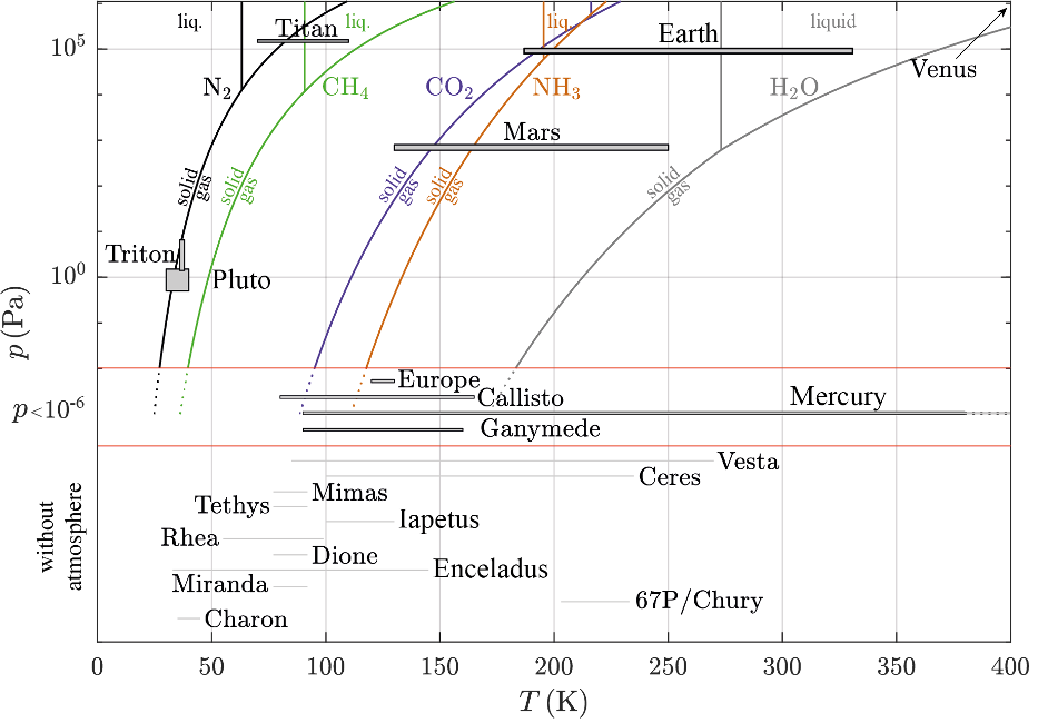
FIGURE 1 – Superimposed phase diagrams of the predominantly represented species (N2, CH4, CO2, NH3, H2O) in the Solar System in (p,T), using the Clausius-Clapeyron relationship.
Scientific goal: To understand the process of material redistribution by the wind on icy planetary surfaces subject to phase changes, we propose a theoretical model coupling of flow dynamics and mass transfer and perform a linear stability analysis [6]. As done for loose bedforms, we use solid transverse bedforms as geomarkers to identify sublimation zones and to deduce erosion rate. We aim to physically and morphologically characterise these periodic waves perpendicular to the main flow over icy substrates and we are looking for analogues to assess the validity of our model before interpreting the observations on other bodies. On Earth, field analogues could be found in extreme cold and icy environment. Similar laboratory experiments are also suggested to complete the dataset.
Sublimation waves analogues: We have identified two possible analogues for sublimation patterns from the literature: in the Blue Ice areas (Fig 2a) of the Antarctic ice sheets [1] and in ice caves such as the Eisriesenwelt cave (Fig 2b) in Austria [7]. We also use new measurements made in a laboratory experiment on the sublimation of CO2 ice in an atmospheric wind tunnel (Fig 2c).
FIGURE 2 – Sublimation waves analogues [6]: (left: a) Blue Ice areas (middle: b) the Eisriesenwelt ice cave (right: c) CO2 ice in an atmospheric wind tunnel.
In all these environments, linear and transverse bedforms appear. However, there are quite different in scales and involve different compositions of the icy substrate and the atmosphere. Despite those differences, the winds that flow on these surfaces are always turbulent and of infinite height and the environmental conditions are favorable to sublimation of ice: the surface temperatures are lower than the triple point and the partial pressure of the species is far from pressure at saturation. These sublimation waves have been classified as net ablation areas from surface energy balance.
Theoretical model for redistribution processes: We consider a simple 2D case of a wavy surface of wavelength l and small amplitude with an overlying turbulent atmospheric boundary layer, of height H much larger that the wavelength. The mass transfer rate varies along the profile and has a maximum somewhere in the troughs, shifted from the crests by a phase lag. This effect allows the growth of a range of wavelengths and their migration, depending on the location of the maximum. The flow is perturbed by the topography and modify the mass transfer in turn, which may lead to the instability of such bedforms.
From the stability analysis [6] we obtain 3 scaling laws: (1) the first law can predict either the friction velocity or the wind speed from a measure of the wavelength and if the viscosity is known, (2) the second law show that the migration velocity is found to scale linearly with the average value of the sublimation rates and thus depends on the kinetics of the phase transition, (3) the third law links the characteristic time of formation with the viscous length and the sublimation rate.
FIGURE 3 – Model (black line), measurements (symbols) and prediction (MNPC) for sublimation waves [6].
Sublimation bedforms as geomorphic markers: The model prediction, black line (Fig 3), is superimposed on the natural terrestrial and the experimental model. This allows us to predict either the friction velocity or the wind speed from a measurement of the wavelength for the Martian Northern Polar Cap. The values predicted are in good agreement with those obtained by the martian climate database at the same place where these sublimation waves have been detected, and those both for the frictional velocities and the wind speeds.
Conclusion: We propose a formation model for the sublimation waves by coupling mass waste with the hydrodynamic instability of the overlaying turbulent flow, in the case where the flow heigh is larger than the wavelength. The subjacent objective was to determine if terrestrial analogues exist or some experimental facilities could be used. We show it is possible to link the dimension of the sublimation waves to their environment and produce three scaling laws that links the geomorphological characteristics of these bedforms (wavelengths, migration, formation time) and the flow (velocity, viscosity, flow height). The adequacy between the observations/experiments and our model allows us to validate these environments as terrestrial/experimental analogues of sublimation waves. New experiments could thus be designed in controlled atmospheric wind tunnel like Aarhus wind tunnel, Denmark to explore controlling parameters.
Acknowledgments: Plan National de Planétologie.
References: [1] Bintanja R. (1999) Reviews of Geophysics, 37(3) :337–359 [2] Herny C. et al. (2014) EPSL, 4013, 56-66. [3] Howard A. D. (2000)Icarus, 144(2) :267–288. [4] Smith I. et al (2010) Nature, 465(7297). [5] Moore et al (2017) Icarus, 287 :320–333, 2017. [6] Bordiec M. et al. (2020) Earth & Sci. Reviews. Sci., 103350. [7] Obleitner and Spötl, (2011) Cryosphere, 5(1) :245–25.
How to cite: Carpy, S., Bordiec, M., Bourgeois, O., Herny, C., Massé, M., and Pochat, S.: Field analogues and laboratory experiments to constrain sublimation waves on planetary icy surfaces, Europlanet Science Congress 2022, Granada, Spain, 18–23 Sep 2022, EPSC2022-1210, https://doi.org/10.5194/epsc2022-1210, 2022.
Introduction
If life ever existed on Mars, its presence on the surface was likely relegated to spatially isolated patches [c.f., Phillips et al. this conference]. It follows that finding evidence for past life on Mars will require careful selection of rover-explorable targets that are most likely to have hosted organisms at or near the surface and retained evidence of those organisms. The salt habitats of paleo-lake basins [1], [2] are examples of habitats with taphonomic windows [3], [4], and as such are high priority targets for astrobiological exploration [c.f,. Phillips et al. this conference]. Salt-encrusted paleo-lake basins on Mars [5]–[7] may contain features that in similar environments on Earth serve as habitats; however, the spatial resolution necessary to detect these features is relatively unknown [8]. Here, we show how deep-learning can be used to understand spatial resolution thresholds for the identification of habitats and apply this method to the habitats in a terrestrial salt-encrusted paleo lake basin (salar), Salar de Pajonales.
Geologic Background
Salar de Pajonales, Chile (SdP, 25°08’29”S, 68°46’20”W, 3547 m, Fig. 1) lies within the Altiplano Puna plateau near the border of the Atacama Desert (hereafter, Altiplano and Atacama, respectively). Salt-encrusted basins in the Atacama and Altiplano experience multiple extreme conditions, including aridity/hyper-aridity [9], intense UV irradiation [10], severe diurnal temperature swings, high evaporation rates [9], and high concentrations of salt, which make them suitable environmental analogs to the salt-encrusted basins of Mars. The surface of SdP hosts regions locally dominated by gypsum and carbonate [11]. Data for our study was collected from a gypsum-dominated area of the salar, designated the “Dome Field” for its many domical gypsum structures [2]. [12] show that microbial (chasmo)endoliths preferentially reside in alabaster habitats within decimeter- to meter-tall domes and ridges [c.f., Phillips et al. this conference].
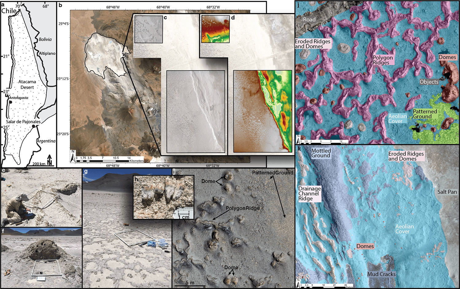
Fig. 1 Overview of Salar de Pajonales (SdP). A) Location of SdP within the Chilean Atacama Desert. B) Outline of SdP, note volcano to its south. C+D) Orthophotomosaic and DEM of the Dome Field generated with drone-collected images. E, F, G) Ridge, Dome, and Patterned Ground (biological soil crust) habitast at SdP, respectively. H) Pink and green horizons show endolithic microbial communities. I) Aerial view of Domes, Ridges, and Patterned Ground (biological soil crust) at SdP. J+K) Human-mapped ground truth classifications of the 12 feature classes in our study site.
Methods
We assessed the confidence with which habitats at SdP (polygon ridges, domes, and patterned ground) could be identified over a series of spatial resolutions with a methodology based on fully convolutional neural networks (FCNs, [13]). An FCN is a convolutional neural network with at least one fully-connected layer that adapts it to the semantic segmentation task. A “Confidence Score” was formulated to represent the degree to which one should trust FCN predictions [8]. The Confidence Score takes into account the correct and incorrect predictions made by the network, as well as the certainty (calculated using the Monte-Carlo Dropout method, [14]) associated with each prediction. BF-Score, precision, and recall were also calculated.
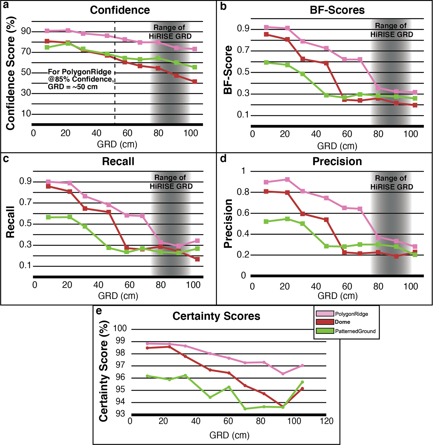
Fig. 2 Results as a function of Ground Resolved Distance (GRD). A) Confidence Score. B) BF-Score. C) Recall. D) Precision. E) Certainty. Gray region represents the approximate range of spatial resolutions achievable with HiRISE.
Results
The general characteristics of Precision, Recall, and BF-Score values as a function of image spatial resolution were relatively consistent between the habitats evaluated (Fig. 2b-d). We interpret the sharp drops in Precision, Recall, and BF-Score to mean that a spatial threshold critical for accurately segmenting (i.e., drawing a boundary around) a feature has been crossed. The threshold occurs at a GRD ~one-third the characteristic length scale of each feature, i.e., when the feature is spanned by 9 to 12 pixels. An analogy can be made to the Nyquist sampling frequency, wherein 2 to 3 pixels are required for a feature to be detected in an image. To achieve a 1-sigma level of identification confidence (Confidence Score ≥~85%) for the PolygonRidge class, a GRD approximately 20% its length scale is required, that is, it must be spanned by 15 to 20 pixels, or 5 to 10 times more pixels than is required to detect the feature. Conversely, Domes require a GRD ~6% their characteristic length scale (spanned by 50 to 65 pixels, or 17 to 33 times its detection limit) to be identified at the 1-sigma confidence level. PatternedGround could not be identified at the 1-sigma confidence level with the spatial resolutions studied here. This pattern suggests an intuitive hierarchy of recognition:
- detection: at 2-3 pixels, it is known that a feature exists
- segmentation: at 9-12 pixels, a boundary can be drawn around the feature
- identification: at ≥ 15 pixels, a class name can be accurately assigned to the feature.
These results emphasize the complexity and feature-specific nature of establishing identification thresholds in spatial resolution, and show that assuming the identifiability of a feature based only on its size may lead to overconfidence in the ability to identify it (e.g., the Dome class).Extending this work to establish the most- and least-identifiable habitats within presently-available images of Mars would be key for triaging habitats into a prioritized list of astrobiology targets and for informing future instrument specification requirements.
References:
[1] A. F. Davila et al., 2008. doi: 10.1029/2007JG000561.
[2] N. W. Hinman et al., 2022, https://www.frontiersin.org/article/10.3389/fspas.2021.797591
[3] R. E. Summons et al., Astrobiology, vol. 11, no. 2. p. 157, 2011.
[4] D. C. Fernández‐Remolar et al., 2013. doi: 10.1002/jgrg.20059.
[5] M. M. Osterloo et al., 2008. doi: 10.1126/science.1150690.
[6] T. D. Glotch, et al., 2016. doi: 10.1002/2015JE004921.
[7] E. K. Leask and B. L. Ehlmann, 2022, doi: 10.1029/2021AV000534.
[8] M. S. Phillips et al., Astrobiology, in review.
[9] J. Houston and A. J. Hartley, 2003. doi: 10.1002/joc.938.
[10] D. Häder and N. A. Cabrol, 2020. doi: 10.1111/php.13276.
[11] C. Rodríguez-Albornoz, Thesis, Universidad Católica del Norte, 2018.
[12] K. Warren-Rhodes et al., Nature Astronomy. in review.
[13] E. Shelhamer, et al., arXiv:1605.06211. p. tran, 2016.
[14] Y. Gal and Z. Ghahramani, ArXiv, vol. abs/1506.02142. 2016.
[15] B. L. Carrier et al., 2020. doi: 10.1089/ast.2020.2237.
[16] B. L. Ehlmann et al., 2016. doi: 10.1002/2016JE005134.
[17] T. C. Onstott et al., 2019. doi: 10.1089/ast.2018.1960.
[18] L. Hays, “NASA Astrobiology Strategy.” 2015.
How to cite: Phillips, M.: What is that? Identification confidence of Mars analog habitats with Deep Learning, Europlanet Science Congress 2022, Granada, Spain, 18–23 Sep 2022, EPSC2022-1200, https://doi.org/10.5194/epsc2022-1200, 2022.
The European Commission (EC) is currently formulating their vision for future research infrastructures (RIs) and how they should deliver improved transnational access (TNA) for the broad scientific and industrial community. There is a major emphasis on ensuring RIs are self-governing and sustainable. Many of the larger, often government supported, RIs will operate as European Research Infrastructure Consortia (ERICs). ERICs are generally established around large national research facilities. The Europlanet Society has instead chosen to be a AISBL (International Non-Profit Organization) based in Belgium ensuring control by the scientific community. Upon granting of the AISBL status, expected later in 2022, the Europlanet Society will be in position to lead or co-operate in any future RI initiatives.
Based on a series of briefings by the EC, it is predicted that existing established RIs such as Europlanet will be expected to collaborate within and across disciplines to offer a wider range of transnational access. For Europlanet this will mean collaboration within the Astronomy-AstroChemistry communities Opticon, RadioNet, ChETEC, etc. In addition, future TNA programmes will be expected to involve:
- more diverse facilities;
- greater interaction with participation by industry;
- greater globalisation with an emphasis on Africa and Asia;
- more active participation from the under-represented European states.
- reduced environmental impact;
We believe that Europlanet is in a strong position to achieve many of these requirements. The next call for modified RIs that provide transnational access is expected to be launched in astronomy-space realm at the end of 2022, for calls in 2023 and 2024. It is therefore necessary to start to formulate ideas for a future TNA programme. The presentation at EPSC will give a brief review of the current status of the Europlanet 2024 RI, and is designed to initiate and stimulate discussion within the planetary community as to their wishes for future TNA facilities, specifically in light of ESA goals to return to the Moon and an increased focus on Exoplanetary science.
How to cite: Davies, G., van Westrenen, W., Merrison, J., Russell, S., Cavalazzi, B., L'Haridon, J., and Mason, N.: The Future and Sustainability of Transnational Access in Europlanet Research Infrastructure, Europlanet Science Congress 2022, Granada, Spain, 18–23 Sep 2022, EPSC2022-126, https://doi.org/10.5194/epsc2022-126, 2022.
Please decide on your access
Please use the buttons below to download the presentation materials or to visit the external website where the presentation is linked. Regarding the external link, please note that Copernicus Meetings cannot accept any liability for the content and the website you will visit.
Forward to presentation link
You are going to open an external link to the presentation as indicated by the authors. Copernicus Meetings cannot accept any liability for the content and the website you will visit.
We are sorry, but presentations are only available for users who registered for the conference. Thank you.
Posters: Mon, 19 Sep, 18:45–20:15 | Poster area Level 1
Activities at a European Planetary Simulation Facility
J. P. Merrison, J.J. Iversen, K.R. Rasmussen, A. Waza
1Institute of Physics and Astronomy, University of Aarhus, DK-8000 Aarhus C, Denmark (merrison@phys.au.dk/ Fax: +45-86120740)
Abstract
This unique and now improved planetary simulation facility is capable of re-creating extreme terrestrial, Martian and other planetary environments. It is supported by EU activities including Europlanet 2024 RI here the latest research and networking activities will be presented. This facility is also used as a test facility by ESA and NASA Mars missions. Specifically it is capable of recreating the key physical parameters such as temperature, pressure (gas composition), wind flow and importantly the suspension/transport of dust, sand or ice particulates. This facility is available both to the scientific and Industrial communities.
- Europlanet Transnational Access
This environmental simulator facility is utilized for a broad range of research programs including; the study of other planets (such as Mars), for recreating extreme terrestrial environments, or in specific investigations involving aerosols and other forms of Aeolian particulate transport. The facility is also involved in the Europlanet 2024 Research Infrastructure through which a trans-national access program is allowing numerous research groups access to this facility. Some selected recent and upcoming projects are listed below;
- Polar CO2 ice on Mars (USA) [5]
- LIBS system on Mars2020 (ISAE France) [3]
- Sand transport and ripples on Mars (P. Claudin, B. Andreotti, et al. 2019)
- Dust aerosols at low pressure. INGV, I [6]
- Flow Testing of a Sonic Anemometer for the Martian Environment (USA) [4]
- In-situ utilization on Mars2020 and dust loading. Imperial College UK [7]
Other activities include the development, testing and calibration of sensor and planetary lander systems, both for ESA and NASA. Testing for missions ExoMars 2020 and Mars Perseverance were carried out.
Figure 1 The main Planetary Simulation Facility 2022 carrying out a Europlanet2022RI funded experiments involving sand transport under Marian conditions and guests;
- Design and operation
The simulator consists of a 38m3 environmental (thermal-vacuum) chamber within which a re-circulating wind tunnel is housed [1]. The wind is generated by a set of two fans which draw flow down the 2m×1m tunnel section and return it above and below. Wind speeds in the range 1-40 m/s have been demonstrated. Cooling is achieved by a novel liquid nitrogen flow system which has achieved temperatures below -160ºC. The inner chamber is thermally isolated from the vacuum chamber. An atmospheric cooling system allowing independent control of the air temperature (tested to -50°C) and a range of particle imaging, microscopy and laser based techniques allow study of aerosols [2].
Improved functionalities of this facility (funded by Europlanet 2024RI) include the implementation of; improved pumping capabilities to lower pressure (<10-4mbar) and improved aeroslization systems for dust and ice studies. Additional recent sensor systems include a new Laser Doppler Velocimeter system and an optical transmission (opacity) sensor for studying aerosol properties.
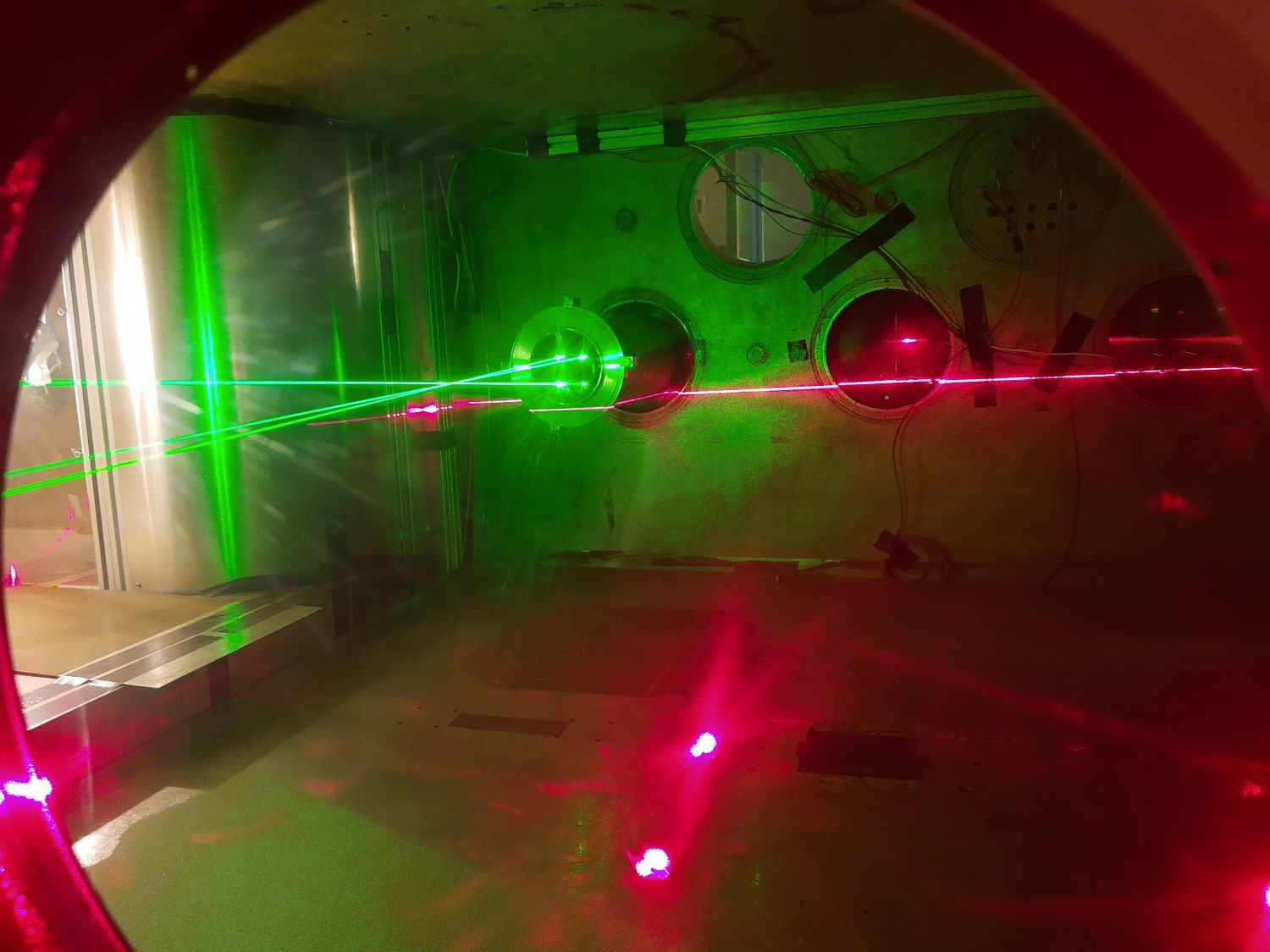
Figure 2 studying resuspended dust using a Laser Doppler Velocimeter and a light transmission (opacity) system.
- Sand, dust and ices on Mars
With control of wind flow at low pressure and temperature this facility is well suited for recreating the environment at the surfaces of terrestrial type planets such as Mars, Earth and Titan. The interaction of wind and the planetary surface, specifically the transport of sand and dust is fundamental to understanding the evolution of the planets’ surface and atmosphere. Laboratory studies of the entrainment, flow, deposition and erosion are scarce and empirical in nature. The effects of low atmospheric pressure, composition, temperature can now be studied in detail.
This laboratory is part of an EU supported European collaboration called ROADMAP including groups from BIRA in Belgium, CSIC in Spain and UDE in Germany, to study dust aerosols on Mars [Home (aeronomie.be)]
Recently Martian Aeolian ripples have been recreated in experiments to investigate the behaviour of wind-driven sand transport under decreasing pressures, from the ambient (1 bar) towards Martian atmospheric conditions, and even to lower pressures than on Mars (2 mbar). In comparison to terrestrial conditions, sand transport at Martian pressures is significantly modified by viscous effects. However, centimeter-scale ripples nevertheless emerge (fig. 2), which match observations made by NASA’s rover Opportunity on the surface of Martian dunes.
Fig. 3 Ripples created at low pressure (P. Claudin, B. Andreotti, et al.).
- Conclusion
This planetary simulation facility has many unique and recently improved features which make it well suited for both planetary research applications and the development/testing of instrumentation. Details of some of the most recent and upcoming collaborative research activities will be summarized. For information on access to this facility please contact the author.
Acknowledgements
This laboratory is a member of Europlanet 2024 RI which has received funding from the European Union's Horizon 2020 research and innovation programme under grant agreement No 871149.
The laboratory is also a member of the ROADMAP project which has received funding from the European Union’s Horizon 2020 research and innovation programme under grant agreement No 101004052.
References
[1] C. Holstein-Rathlou, et al., American Meteorological Society, 31, 447 (2014)
[2] S. Alois et al., J. Aerosol Science 106, 1, (2017)
[3] Murdoch, N., et al., Planet and Space Sci, 165 (2019) 260-271
[4] White, R. D. et al. AIAA Scitech 2020. AIAA2020-0712
[5] G. Portyankina et al., Icarus 322, 210–220 (2019)
[6] E. del Bello, et al., Scientific Reports, 8, 14509 (2018)
[7] Andreotti and Claudin et al.. PNAS 5, 118 (2021)
How to cite: Merrison, J., Iversen, J. J., Rasmussen, K., and Waza, A.: Activities at a European Planetary Simulation Facility, Europlanet Science Congress 2022, Granada, Spain, 18–23 Sep 2022, EPSC2022-122, https://doi.org/10.5194/epsc2022-122, 2022.
1. Introduction
The dynamic of lava flows as inferred from rheological models is characterized by physical parameters, such as viscosity and yield strength (assuming the flow is a Non-Newtonian fluid). Historically, the rheological behavior of lava flows is controlled, and determined (when samples are available), from intrinsic parameters, e.g chemical composition of the melt, crystal fraction rates, outgassing. Rheology is also reflected in outer characteristics such as the 3D morphology [1], whose analysis is the most common approach in planetary science.
To study extraplanetary volcanic features, terrestrial analogue sites are useful. The Altiplano Puna Volcanic Complex (APVC), a volcano-tectonic province located at the Central Andes, has been suggested as an excellent site for the combined use of satellite imagery and ground truthing studies, being extraordinarily well-exposed and preserved due to the aridity of the Atacama Desert [2]. Its volcanic units vary in composition and geomorphology [3], representing potential analogs to a range of Mars volcanic features [4].
In this work, we focus on Andean volcanic geoforms from the APVC and apply two main approaches: chemical and morphological, to constrain the rheological behavior and viscosity estimates by testing several existing models [e.g., 1] in the Atacama Desert site, as an analog for Mars lava flows.
2. Methods
About 30 terrestrial lava flows of age < 1 Ma from stratovolcanoes and monogenetic centres from the APVC (21°S 69°W to 24°S 67°W) have been study from orbit and field (Table 1). The composition of these lava samples ranges from basaltic-andesite (53.07 wt.% SiO2) to dacite (64.62 wt.% SiO2) [5,6,7].
2.1 Rheological models
Lava flow viscosities are estimated using two different, but complementary approaches.
First, the melt viscosity (ηG) is calculated using the geochemical composition of the lava samples [8]. Then, the lava flow geometry is used as an input in existing models [9,10,11] to determine the apparent viscosity (ηA)from orbit. Morphological dimensions of the lava flows are measured using topographic data to determine the flow length, height, width, and slope angle from a 12.5 m/pixel Alos Palsar digital elevation model.
The ratio of the apparent viscosity to the melt viscosity (relative viscosity ηR) is known to increase with the presence of crystals. Existing models rely on the Rosco-Einstein equation to quantify the crystal effects on viscosity, assuming a theoretical maximum packing fraction (φ) at which magmas essentially become solid [10]. We further evaluate the amount and shape of phenocrysts in the lava flows through petrographic analyses.
3. Results
Results for a first selection of lava flows are presented in Table 1. Calculated melt viscosities (ηG) for basaltic andesites and dacites range from 5.8E+04 to 3.58E+08 Pa.s, which is in agreement with the theoretical viscosity values of intermediate silicic flows. However, apparent viscosities (ηA) estimated from orbit show values ranging from 8.0E+07 to 2.30E+13 Pa s (Table 1). This subset of lava flows returns high relative viscosity (ηR) values in the order of 10E+03 to 10E+07, implying packing fractions close to the theoretical maximum. Petrological analyses confirm that all these samples contain phenocrysts with abundances comprised between 7.09 and 19.67%, as obtained using the modal counting method.
4. Discussion and perspectives
Different approaches have been used to estimate lava viscosities, with large gaps observed between remote sensing estimates and actual melt viscosities. With a complete range of geochemical compositions and crystal abundances, our catalog should help to note some limitations of existing rheological models. An inherent limitation is the use of single values for viscosity and yield strength for each lava flow because these parameters may indeed vary within the lava flow, both parallel to the flow direction, and vertically. Some authors agree that crystallinity is likely to play a more important role in viscosity changes in less evolved lavas [1]. On the contrary, for more evolved compositions, the crystallization sequence might not be the principal or decisive factor affecting the viscosity, compared to degassing and glass content [12]. Combining different rheological models for a wider compositional (i.e., SiO2 content) and textural (i.e., more aphanitic) range may allow us to better understand complex rheological scenarios of extra-terrestrial lava flows. On Mars, previous estimates of lava viscosities seem to be more consistent with basaltic to andesitic compositions [1], however, more evolved rocks (e.g., trachyandesite and trachyte) have been described recently based on orbital, in situ and meteorite data [13], and could be identified with our approach.
|
Volcano |
TAS composition |
L (m) |
H (m) |
W (m) |
Apparent viscosity (ηA) |
Melt |
Relative |
Packing fraction (φ) |
|
El Negrillar |
Basaltic andesite [12] |
1809 |
53 |
827 |
3.10E+11 |
3.58E+08 |
4.5E+05 |
0.74 |
|
La Poruña |
Basaltic andesite |
7670 |
59 |
1778 |
8E+07 |
5.8E+04 |
1.5E+03 |
0.70 |
|
Azufre |
Andesite |
6740 |
336 |
3227 |
2.29E+13 |
1.3E+06 |
2.8E+07 |
0.73 |
|
Paniri |
Trachyte |
8140 |
199 |
2013 |
1.02E+12 |
1.34E+06 |
7.6E+05 |
0.73 |
|
San Pedro |
Dacite |
11800 |
153 |
2526 |
3.15E+11 |
1.12E+06 |
2.8E+05 |
0.73 |
|
El Negrillar |
Dacite |
1679 |
54 |
509 |
2.30E+13 |
2.00E+06 |
4.6E+03 |
0.72 |
Table 1. Summary of rheological parameters calculated for selected lava flows in study. η is in Pa.s.
5. Acknowledgements
This work is funded by ANID - Fondecyt de Iniciación N° 11200293 and N° 11200013, Otelo JCJC and the ANR Mars-Spec grants.
6. References
[1]Chevrel et al., 2013. EPSL 384, 109-120.[2]Flahaut et al., 2017. Icarus, 282, 152-173.
[3]Wörner et al., 2018. Elements 14 (4), 237-244.[4]De Silva et al., 2013. Analog Sites for Mars Missions II.
[5]González-Maurel et al., 2019. Lithos 346-347.
[6]Godoy, B. 2019. JSAES 95 102295.
[7]Parra-Encalada et al., 2022. J. Volcanol. Geotherm. Res, 426, 107541.
[8]Giordano et al., 2008. EPSL 271, 123-134
[9]Hulme, G, 1974. Geophys. J. R. Astron. Soc. 39, 361-383.
[10]Warner and Gregg, 2003. J. Geophys. Res. 108, No. E10, 5112
[11]Pinkerton and Wilson, 1994. Bull. Volcanol, 56, 108-120.
[12] Hess and Dingwell, 1996.Minerals, 81 1297- 1300.
[13]Sautter et al., 2016. Lithos, 254-255, 36–52.
How to cite: Muñoz, B., Flahaut, J., Larrea, P., Ford, M., González-Maurel, O., and Godoy, B.: Testing rheological models on Central Andean volcanic geoforms as analogues for Mars, Europlanet Science Congress 2022, Granada, Spain, 18–23 Sep 2022, EPSC2022-276, https://doi.org/10.5194/epsc2022-276, 2022.
Laboratory experiments mimicking the saltation process in a Mars-like atmosphere show that triboelectric processes lead to excitation and ionization of molecules and atoms in the gas phase [1]. (Saltation refers to the processes when the sand grains are lifted up into the air and suspended for a short distance before falling back to the surface with a parabolic trajectory). Spectral analysis of the triboluminescence accompanying the processes reveals excitation energies of at least 21 eV [1-2]. This result has inspired us to investigate if chemical changes are associated with the processes.
Here we report month-long saltation mimicking experiments in a quartz ampoule with quartz grains (SiO2) in a methane (CH4) atmosphere. As the saltation proceeds, we observe a color change of the grains from white to reddish as seen in Fig. 1. Our experiments report laboratory results of photochemical process. We are not investigating saltation on planetary bodies.
Figure 1. A: Quartz sample prior to the saltation experiment. B: Quartz sample after 340 days of a saltation in a quartz ampoule containing a methane atmosphere with an initial pressure of 561 mbar.
The reddish grain-color looks like the color observed on the polar caps of Triton [3, 4] and Charon [5] as well as on the dwarf planet, Pluto [6].
The color of Charon is linked to cold-trapped methane rich volatiles [5]. The color on Triton and Pluto could be the result of photochemistry, leading to organic compounds formed in the atmosphere under exposure to UV radiation. The compounds deposit on the surface where they - along with potential gases, like N2 and CO - form tholin-like materials [7, 8]. The patches could also be formed by UV radiation of the surface material containing N2, CO and CH4. The excitation energies in the saltation experiments (at least 21 eV [1]) are similar to the energy of the hard UV radiation reaching the planetary bodies suggesting that analysis of the saltation produced reddish material could lead to insight into the reddish patches on these bodies. Our saltation experiments suggest an alternative way of forming tholins on planets with a methane-containing atmosphere and a solid surface.
We study the reddish material with X-ray photoelectron spectroscopy (XPS), reflection spectroscopy and solid-state Raman spectroscopy. In addition, electron structure calculations give some insight into the complex chemistry. Experiments and calculations indicate the observations of color change can be explained as a coating of the quartz grains by polydiene polymers [9].
Calculated potential minima of a model for a polydiene with 10 C-atoms anchored to a quartz grain. A: quartz grain with 20 Si-atoms. Color code: red = O, steel = Si, green = C, and white = H.
References
[1] J. Thøgersen, et al., Light on windy nights on Mars: A study of saltation-mediated ionization of argon in a Mars-like atmosphere. Icarus 332, 14-18 (2019).
[2] M. A. Lieberman, and A. J. Lichtenberg, (2005). Principles of plasma discharges and materials processing (2nd ed.). Hoboken, N.J.: Wiley-Interscience. 546. ISBN 978-0471005773. OCLCZZ 59760348.
[3] D. F. Strobel, et al., The photochemistry of methane in the atmosphere of Triton,
Geophys. Res. Lett. 17(10), 1729-1732 (1990).
[4] W. M. Grundy, et al., Spectroscopy of Pluto and Triton at 3–4 Microns: Possible evidence for wide distribution of nonvolatile solids, Astron. J. 124, 2273–2278 (2002).
[5] W. M. Grundy, et al., The formation of Charon’s red poles from seasonally cold-trapped volatiles. Nature 539, 65-68 (2016).
[6] S. A. Stern, et al., The Pluto system: Initial results from its exploration by New Horizons. Science 350, aad1815 (2015).
[7] C. Sagan, and B. Khare, Tholins: organic chemistry of interstellar grains and gas, Nature 277, 102-107 (1979).
[8] G. D. McDonald, et al., Chemical investigation of Titan and Triton tholins. Icarus,. 108(1), 137–145 (1994).
[9] P. Nørnberg, et al., Methane as a reddish coating agent. Icarus 382, 115023 (2022)
How to cite: Nørnberg, P. and Knak Jensen, S. and the Mars Team, Aarhus University: A model for the reddish patches seen on Triton, Pluto and Charon, Europlanet Science Congress 2022, Granada, Spain, 18–23 Sep 2022, EPSC2022-332, https://doi.org/10.5194/epsc2022-332, 2022.
Observations of the geological setting of the Martian surface suggest traces of a cold and semi-arid era during the evolution of the planet, characterized by desertic and evaporitic environments. Despite their hostile conditions, these challenging environments host highly adapted and specialized extreme-tolerant and extremophilic microorganisms that evolved unique strategies to survive the harshest conditions on Earth. like those observed in terrestrial microorganisms inhabiting extreme localities. Here, one of the most common strategies of microbial life is endolithism, defined as the colonization of the pores and fissures within rocks, where microorganisms are protected from external harsher conditions. Moreover, the endolithic communities from Mars terrestrial analogues represent excellent models to understand how putative microorganisms may be adapted to the Martian environments and how to detect their signatures. In this optic, the proposed study aims to characterize for the first time endolithic communities and their biosignatures from distinct Mars-relevant rock substrates (ignimbrite and evaporites) in the Laguna Verde Complex, a complex of high-altitude hypersaline lakes surrounded by a desertic and volcanic area, located in the Puna Plateau in the Argentinian Andes. During the sampling campaign, which was performed in the context of the Europlanet 2024 Transnational Access program, rock samples were collected inside and in the surrounding desert area to cover most of the different potential endolithic habitats of the site. Microbiome characterization through Illumina amplicon sequencing, untargeted metabolomic analyses and microscopy studies are currently being undertaken on the collected samples.
How to cite: Aureli, L. and Coleine, C.: Untangling rock-inhabiting microorganisms and their biosignatures from the Mars-like area of Puna Plateau, Argentinian Andes, Europlanet Science Congress 2022, Granada, Spain, 18–23 Sep 2022, EPSC2022-343, https://doi.org/10.5194/epsc2022-343, 2022.
Introduction:
The interest for the Moon has risen with many missions being planned for the Moon surface culminating to the Artemis missions, spearheading a new era of human presence on the lunar surface. At the same time a recent paper (1) provided an overview of the current state of Martian research and understanding. A common theme on both of these endeavors is the requirement of extensive research across the fields of astrobiology, the frontier of ISRU technologies and habitability research under simulated conditions of those environments. A large number of Lunar and Martian Simulants has been developed over the past decades, often though produced rapidly with lower fidelity to satisfy demand (2). Towards this purpose, our group made an effort to develop such materials, since in Greece only potentially analogue locations for simulated research exists. This research was initiated with the introduction of a new simulant classification system, after having highlighted a number of issues that pertain on the facet of Martian Simulants. We here report on the development of new simulants we produced for the Lunar and Martian surfaces.
Methodology:
Initially, we scrutinised the literature focusing on three focal points of research to collect data on the composition of Lunar and Martian surface location, the Lunar Curator Facility, the Analyst’s Notebook and the respective publications on simulant production, in order to identify which datasets have been already utilised. Based on these data, we selected one Lunar and two Martian locations to produce simulants. For the Moon we selected the 15260 Apollo Sample which has been extensively studied. (3) For Mars, we opted for the Rocknest and Gobabeb targets, which are 2 of the most cited and compared sites for simulant production. More specifically, for Moon we utilised the chemical analysis provided by (3) and for Mars those provided by (4).
For the simulant development we collected a number of igneous rock samples from the field, and acquire a number of pure mineral phases, for use as individual components, presented in table 1. All of the materials utilised by our team in the synthesis of the simulants have been firstly crushed and grounded to a grain fraction of under 1 mm. A portion of the material was further crushed in under 250 μm, and later refined for XRD analysis. Each sample was then scanned in three random locations via SEM-EDS and the average analysis was taken as the sample’s chemistry. Thus, via those two analytical techniques, the background of the chemical and mineralogical make up of our inventory of materials was established.
In order to establish the quality of our simulants we utilised the Figure of Merit (FOM) proposed by (5) and applied by (6). By using this system you can deduce the accuracy of your simulant based on how close the percentages of chemical oxides are to the reference sample.
Simulants:
Up to the point of writing, our team has produced a total of four simulants, two for the Moon and two for Mars. Initially a production of two prototypes for a Lunar and Martian simulant, Simulant #1 and #2 respectively, were made by mixing three individual mineral and rock components to verify the method of synthesis and correct any mistakes. However, even at that stage the theoretical FOM of our Simulant #1 was above 95% when compared to the Apollo 15260 sample, and Simulant #2 for Mars had FOM 90,7% and 89% for the Rocknest and Gobabeb targets respectively. (Table 1)
Based on the preliminary results we produced refined simulants, Simulant #3 and #4 for Moon and Mars respectively, using additional components materials as showed in table 1. Thus, Simulant #3 for the Apollo 15260 sample reached FOM of almost 96% and Simulant #4 for Mars reached FOM of 94,6% and 91,6% for the Rocknest and Gobabeb targets, respectively. (Table 1)
Future Goals:
The goal of this project is to try and make simulant materials for Moon and Mars more accessible to the scientific community, but also provide materials of higher fidelity and accuracy. Based on their chemistry, the FOM values on the martian simulants are higher than those presented in (6), suggesting that our endeavor has significant prospects compared with the fidelity of other simulants and providing the confidence that higher accuracy simulants can be synthesised. Furthermore, an additional number of analytical techniques will be used to verify their fidelity. Additionally, by the acquisition of additional mineral phases and rock samples we are targeting to increasing the FOM values. A short term requirement is also the availability of well-known simulants in order to be used in the OxR ESA project (7).
References:
- H. G. Changela et al., Mars: new insights and unresolved questions. International Journal of Astrobiology, 1-33 (2021).
- G. H. Peters et al., Mojave Mars simulant—Characterization of a new geologic Mars analog. Icarus 197, 470-479 (2008).
- A. Duncan et al. (1975) Interpretation of the compositional variability of Apollo 15 soils. in Lunar and Planetary Science Conference Proceedings, pp 2309-2320.
- C. Achilles et al., Mineralogy of an active eolian sediment from the Namib dune, Gale crater, Mars. Journal of Geophysical Research: Planets 122, 2344-2361 (2017).
- C. Schrader et al. (2009) Lunar regolith characterization for simulant design and evaluation using figure of merit algorithms. in 47th AIAA Aerospace Sciences Meeting Including the New Horizons Forum and Aerospace Exposition, p 755.
- L. E. Fackrell, P. A. Schroeder, A. Thompson, K. Stockstill-Cahill, C. A. Hibbitts, Development of Martian regolith and bedrock simulants: Potential and limitations of Martian regolith as an in-situ resource. Icarus 354, 114055 (2021).
- ESA (2022) https://www.esa.int/Enabling_Support/Space_Engineering_Technology/Moon_and_Mars_superoxides_for_oxygen_farming.

Table 1. Simulant components and Figure of Merit percentages.
How to cite: Stavrakakis, H.-A., Argyrou, D., and Chatzitheodoridis, E.: Introducing the First Greek Martian and Lunar Simulants, Europlanet Science Congress 2022, Granada, Spain, 18–23 Sep 2022, EPSC2022-611, https://doi.org/10.5194/epsc2022-611, 2022.
1 Introduction
The Finnish Meteorological Institute (FMI) has developed relative humidity instruments for several Mars lander missions. Calibration of these instruments can be challenging due to the required temperature, pressure and humidity conditions that can be reliably simulated by only a few laboratories. Humidity measurements in Martian conditions have been previously performed for these instruments in the FMI’s laboratory and the Michigan Mars Environmental Chamber (MMEC) at the University of Michigan. A new measurement campaign was performed at the Planetary Analog Simulation Laboratory (PASLAB) of the German Aerospace Center (DLR) during autumn 2020 and spring 2021. The campaign included three ground reference models (REF) of FMI’s relative humidity instruments: REMS-H of the MSL Curiosity rover [1], MEDA HS of the Mars 2020 Perseverance rover [2] and METEO-H developed for the ExoMars 2022 surface platform [3]. All three instruments are based on HUMICAP® capacitive thin-film polymer sensors by Vaisala as well as Vaisala’s ASIC technology. REMS-H has three HUMICAP sensor heads, while MEDA HS and METEO-H both contain two newer types of HUMICAP sensors which provide a larger dynamic capacitance range and include integrated resistive PT1000 sensors for measuring the temperature of the sensor head. The REF models of each instrument are identical to the flight models and have gone through testing and calibration campaigns at FMI together with the flight models.
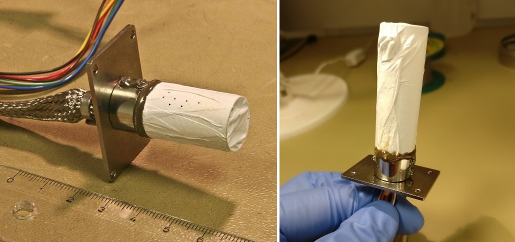
Figure 1: REMS-H (left) of the MSL Curiosity rover and MEDA HS (right) of the M2020 Perseverance rover. METEO-H for ExoMars 2022 is identical to MEDA HS. The electronics and sensor heads are located on a PCB inside a cylindrical Faraday shield. The Faraday shield is covered with PTFE membrane filter to protect the sensor from dust.
The main purpose of the measurement campaign at the DLR was to obtain calibration data in multiple humidity points in CO2 within the instruments’ operational temperature and pressure ranges. The instruments have been calibrated at the FMI using two humidity points in CO2, resulting in satisfactory quality but a notable calibration uncertainty. The new multi-point data are used for complementing the calibration of MEDA HS and METEO-H flight models, as well as to check REMS-H calibration.
2 Test setup
The DLR PASLAB facility, designed to simulate Martian near-surface atmospheric conditions, is used for habitability-related investigations and sensor studies [4][5]. In this measurement campaign the environmental conditions were controlled in terms of gas type, pressure, temperature and relative humidity. The setup is described in Figure 2. The instruments were enclosed in the same measurement chamber as has been used in the FMI’s laboratory (see Figure 3), and the chamber was connected to the environmental control system. As part of the DLR’s own experiment, another chamber with humidity sensors was connected to the system for simultaneous measurements, with one sensor also placed inside the FMI’s chamber for comparison.
The measurements were performed at stable temperature points between -70 °C and -30 °C and pressure points ranging from 5.7 hPa to 9.8 hPa in CO2 gas. At each temperature and pressure combination, a sequence of stable humidity points was run by an automatic program, increasing the humidity in steps from the driest point to the highest humidity and back. Some continuous measurements were also performed in changing humidity. At the end of the campaign, a different gas mixture imitating the true Martian atmospheric composition was tested to investigate possible effects on the sensor behavior.
Figure 2: Setup of the environmental control and measurement system at the DLR PASLAB. Credit: DLR.
Figure 3: Cutaway illustration of the measurement chamber with the three FMI's ground reference models inside.
3 Campaign outcome
The measurement campaign was completed in May 2021 with successful outcomes. All planned temperature and pressure combinations were performed once or twice with a sufficient range of humidity points. However, at -30 °C temperature only points up to about 30 %rh could be achieved due to system limitations. We obtained a comprehensive set of stable humidity point data for each of the humidity sensors, as well as some data in changing humidity. Figure 4 shows the stable humidity points measured by one HUMICAP sensor from each instrument. The results are as expected: the temperature dependence is observed as a clear spread of capacitance readings and the pressure effect as a slight dispersion. Using the Martian-like gas composition did not seem to affect the sensor behavior compared to pure CO2.
Figure 4: Selected measurement points in different temperature and pressure combinations shown for one HUMICAP sensor of each REF model: MEDA HS (upper left), METEO-H (upper right) and REMS-H (lower center). The y-axis represents the reference relative humidity in the measurement chamber and the x-axis the sensor output capacitance. Measurements in the Martian atmospheric gas composition are marked with green stars.
4 Conclusions
The humidity measurement campaign at the DLR PASLAB was performed between September 2020 and May 2021. As an outcome we obtained valuable datasets for MEDA HS, METEO-H and REMS-H ground reference models consisting of multiple relative humidity points over the sensors’ range from 0 %rh to 100 %rh in low pressure CO2. The results were in line with previous laboratory measurements of these instruments.
References
[1] Harri, A.-M. et al.: Mars Science Laboratory relative humidity observations: Initial results. J Geophys Res Planets 119, 2132–2147 (2014).
[2] Rodriguez-Manfredi, J.A. et al.: The Mars Environmental Dynamics Analyzer, MEDA. A suite of environmental sensors for the Mars 2020 mission. Space Sci Rev 217:3, 48 (2021).
[3] Vago, J. et al.: ESA ExoMars program: The next step in exploring Mars. Sol Syst Res 49, 518-528 (2015).
[4] Lorek A. and Koncz A.: Simulation and measurement of extraterrestrial conditions for experiments on habitability with respect to Mars. In Habitability of Other Planets and Satellites, vol. 28, 145–162 (2013).
[5] Lorek A. and Majewski J.: Humidity measurement in carbon dioxide with capacitive humidity sensors at low temperature and pressure. Sensors 18. (2018).
How to cite: Jaakonaho, I., Hieta, M., Genzer, M., Polkko, J., Lorek, A., Garland, S., de Vera, J.-P., and Harri, A.-M.: Relative humidity laboratory measurements in Martian atmospheric conditions, Europlanet Science Congress 2022, Granada, Spain, 18–23 Sep 2022, EPSC2022-819, https://doi.org/10.5194/epsc2022-819, 2022.
The icy satellites of the Solar System, such as Europa, Ganymede and Enceladus, show widespread evidence for brittle morphotectonic structures (fractures/faults) that provide insights to infer the kinematics and the mechanical properties of their crusts. Their investigation is pivotal for the understanding of the tectonic regimes responsible for their formation. In addition, stress-related structures represent potential conduits or enhanced pathways for fluid migration thus connecting the surface and the sub-crustal layers. Such processes are significant to understand internal processes of icy bodies. Their investigation is constrained at regional-scale coverage of the remote sensing imagery.
Glaciers and ice sheets represent optimal terrestrial analogues, showing deformation styles similar to those in the icy satellites, and being the excellent sites to further explore, verify and confirm what observed through remote sensing on the geology of icy satellites. Although the formation processes differ, the similarity of their structures at surface allows quantifying and predicting the state of deformation in the icy satellites at different scales of investigation.
The UPSIDES project aims to investigate and compare the tectonic structures of the glaciers with those on the icy satellites, by means of multi-scale approach of both remote-sensing and field survey.
We propose a structural investigation in the Russell and Isunguata Sermia glaciers, located at the western margin of the Greenland Ice Sheet. Their investigation attempts: i) to identify scaling laws between the tectonic structures measured in the glacier outcrops and their equivalent mapped on satellite images; ii) to relate and compare such scaling laws with structures mapped on deformed areas of the icy satellites; and iii) to infer the tectonic styles at local-scale on the icy satellites. The knowledge of the tectonic setting at local-scale and its comparison with that at regional-scale, allow us to better understand the tectonic process and to characterize structures that are exclusively identified at regional-scale (such as in the icy satellites).
In this contribution we present the preliminary results of the analyses of data collected during the field campaign conducted on July 2021 in Greenland, at the Russell and Isunguata Sermia Gl., in the Europlanet 2024 RI's Transnational Access field analogue in Kangerlussuaq.
Field measurements include the characterization of the ice brittle deformation (e.g., fractures and fault) by the quantification of their azimuth, dip, length, width, throw and spacing. This allow us to recognize the tectonic settings and regimes responsible for their formation. In parallel, we performed a structural mapping on satellite images, which cover the locations where the investigated outcrop occur, and we derived the attributes of the mapped structures. We performed then paleo-stress analyses of the data from both local- and regional-scale, which in turn have been related. The obtained results are consistent and suggest strike-slip kinematics. Such results are compared with areas that show similar tectonic setting on Ganymede and Europa and support the understanding of the possible local-scale setting at surface. In addition, the field data allow us to identify the structures that ease the fluid migration.
The obtained results from this project aim to contribute to advance the study of icy surface tectonics and will support the preparation of planetary programs, such as JUICE mission, for dedicated observations and target areas.
Acknowledgments: This project has received funding from the European Union's Horizon 2020 research and innovation programme under grant agreement No 871149. The activity has been realized under the ASI-INAF contract 2018-25-HH.0.
How to cite: Rossi, C., Cianfarra, P., Lucchetti, A., Pozzobon, R., Penasa, L., Munaretto, G., and Pajola, M.: Unravelling icy Planetary Surfaces: Insights on their tectonic DEformation from field Survey - UPSIDES, Europlanet Science Congress 2022, Granada, Spain, 18–23 Sep 2022, EPSC2022-874, https://doi.org/10.5194/epsc2022-874, 2022.
Abstract
During the fifth International Summer School held on Vulcano (Eolian Islands, Italy) in June 2019 we started the investigation of volcanic deposits with different spectral instruments combining mineralogical, elemental and molecular information [1, 2]. The island of Vulcano presents an extremely large variety of volcanic products [3] in extreme acid alteration conditions. Acidic alteration may also have been a key process throughout Martian geologic history making Vulcano a perfect analog for studies on Mars by defining the geochemistry at these sites. In this work we present an update of our spectral investigations based on the VIS-NIR spectral measurements.
Instrumentation and Methods
In the field we used a portable spectro-radiometer (PSR+3500) that works in the visible and near-infrared spectral range (350 – 2500 nm) with a spectral resolution between 3 and 8 nm, which is best used for mineralogical content of the investigated deposits.
In order to investigate the measured spectra we used a combination of open spectral libraries such as provided by the USGS [4] and the PDS GeoScience Node [5]. To compare the spectra measured in the field with entries in these spectral libraries, spectral matching algorithm implemented in the IDL/ENVI software were employed. The Spectral Angle Mapper (SAM) algorithm [6] determines the spectral similarity between two spectra by calculating the angle between the spectra and treating them as vectors in a space with dimensionality equal to the number of bands. The Spectral Feature Fitting (SFF) algorithm [7] compares the fit of measured spectra to reference spectra using a least-squares technique.
Study area
Vulcano is one of the Aeolian Islands situated in the Tyrrhenian Sea northeast of Sicily, Italy [3]. Above sea-level volcanic activity in this region began around 400 ka due to the subduction of the African plate under the Eurasian plate, triggering tectonic instability and risingmagma, resulting in volcanic activity in the region [8].
The data collected for this study mostly stem from classical lava rocks with dark and bright phenocrysts and dark glass as well as extensive ash deposits from different phases of the volcanic activity on the island (Fig. 1). Recently active fumaroles provided numerous sulphur deposits onto the lava rock. Of particular scientific interest, was the alteration of the lava rocks, which dominated an outcrop directly at the coastline at the foot of the main caldera. Here the lava rocks are constantly under the influence of subareal and submarine fumarolic activity (Fig. 2). Three spots showing different phases of altered lava rock displaying a reddish, yellowish to whitish surface and particular crystal growth were investigated in detail.
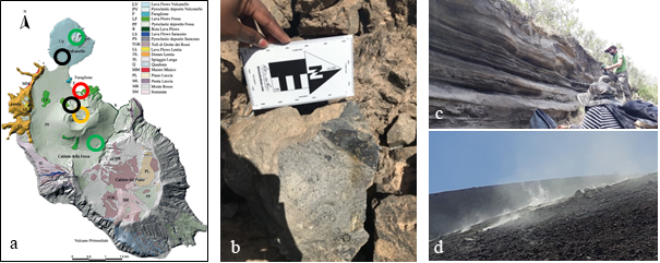
Figure 1: a) Geologic map of Vulcano [9] highlighting the investigated areas dominated by lava rock (black circles), volcanic ash (green circles), fumaroles (orange circle) and alteration materials (red circle) (see Fig. 2).
Figure 2: a) Study area of alteration of lava rocks with three spectrally investigated spots b) 1, c) 2 and d) 3 indicated by the white circles.
Mineral assemblages derived from VIS-NIR spectral measurements
Figure 3 shows a selection of spectra measured at spot 1 and 3. At spot 1 a typical alteration sequence of the lava rock could be identified with a distinct transition from iron-bearing lava rock with a spectrum similar to basalt and/or palagonite to material dominated by sulphates. In addition to ubiquitous amorphous silica an enrichment in Fe- and Al bearing alteration minerals such as jarosite and alunite are evident (Fig. 3). Both minerals appear to be rich in K (less Na) in the studied area. The high content of K is typical for lava rocks on Vulcano [3].
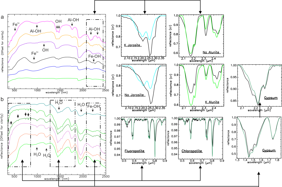
Figure 3: Example spectra measured at a) spot 1 and b) spot 3 (see Fig. 2) with the best fits derived with the matching algorithm from the comparison with library spectra separately for specific absorption features.
At spot 3 the strongly altered rock portions are dominated by the spectral signature of gypsum. Nevertheless, characteristic absorptions in the visible portion of these spectra indicate that gypsum might be sometimes accompanied by the phosphor bearing mineral apatite.
The identified alteration minerals are believed to directly result from the interaction between the surface of the lava rock with the volcanically-derived acid fluids. Remobilized material form the lava rock constitutes the main elements in the new mineral phases in the altered rock such as jarosite and alunite. Similar, the siliceous material is progressively reddened by iron and the calcium of the lava rock is consumed in the formation of gypsum [10].
Summary
Acid-sulfate alteration of basalt by SO2-bearing volcanic vapors has been proposed as one possible origin for sulfate-rich deposits on Mars [11]. Further analysis will enable to better understand the mineralogical and geochemical pathways involved in acid alteration of lava rocks. A second field planned for June 2022 will focus to investigate areas from older, extinct fumaroles in order to study how long the mineralogical and geochemical changes are likely to be preserved.
Acknowledgements
The Vulcano Summer School in 2019 was an extension of the previous four Summer Schools supported by the Helmholtz Alliance Robotic Exploration of Extreme Environments (ROBEX) and the EU-Europlanet program.
The Vulcano Summer School 2022 is supported by the ARCHES Project (Helmholtz Association Project Alliance ZT-0033) with institutional support from universities and research institutions such as DLR, Jacobs University and University Freiberg.
References
[1] Stephan et al. (2019), EPSC Abstracts Vol. 13, EPSC-DPS2019-2062, 2019.
[2] Rammelkamp, K. et al. (2021).. Spectr. Acta Part B: Atomic Spectroscopy, 177, 106067.
[3] De Astis G. et al. (2013). Geol. Soc. Lond. Mem. 37 (1), 281 LP – 349.
[4] Kokaly, R.F. et al. (2017), U.S. Geological Survey Data Series 1035, 61 p.
[5] Murchie, S. et al (2007), JGR 112:E05S03.
[6] Kruse, F. A. et al. (1993), Remote Sensing of Environment 44 (1993): 145-163.
[7] Clark, R. N. et al. (1991), Proceedings, 3rd Airborne Visible/Infrared Imaging Spectrometer (AVIRIS) workshop, JPL Publication 91-28 (1991): 2-3.
[8] Peccerillo, A. (2005), Petrology, Geochemistry, Geodynamics. 173-177, 190-193.
[9] Gioncada, A. et al. (2003), Journal of Volcanology and Geothermal
Research, 122(3–4), 191–220. https://doi.org/10.1016/S0377-0273(02)00502-4
[10]Vishiti et al. 2018, Int. Journal of Geoscience, 9, 513-527.
[11] Squyres, S. W. et al. (2007), Science,316, 738–742.
How to cite: Stephan, K., Gwinner, K., Schröder, S., Kristin, R., Baque, M., Grindrod, P., Pisello, A., Sohl, F., Thomsen, L., and Unnithan, V.: Spectral investigation of volcanic alteration deposits on Vulcano island /Italy as planetary analog for acid alteration conditions on Mars, Europlanet Science Congress 2022, Granada, Spain, 18–23 Sep 2022, EPSC2022-974, https://doi.org/10.5194/epsc2022-974, 2022.
The identification of novel terrestrial sites that are analogous for other planetary bodies is an active area of research within astrobiology, because of the logistical and financial difficulties in obtaining extraterrestrial samples for analysis. Characterisation of potential analogue sites is undertaken to assess how accurately they represent a specific extraterrestrial environment. Analysing their physicochemical conditions and microbial communities are key components of these studies to understand what metabolisms would be viable in such environments.
One such novel analogue environment is the salt plains of Western Sahara. Western Sahara is one of the driest regions on Earth. It is located on the northwest coast of West Africa and is characterised by high UV exposure, low annual precipitation and water activity, subsurface water and high annual temperatures. These features make Western Sahara a potential analogue site for Mars during the Noachian-Hesperian transition period (3.5 – 3.8 Ga), when the atmosphere began to thin and surface water started evaporating (Warner et al., 2010), similar to other terrestrial deserts, such as the Atacama Desert and the McMurdo Dry Valleys.
The hypersalinity, aridity and high UV radiation levels of the Western Sahara salt plains would also be appropriate to study whether dissimilatory sulfur metabolisms would be viable in a Noachian-Hesperian Mars analogue environment. Dissimilatory sulfur cycling refers to the use of inorganic sulfur compounds for energy conservation and it has been recognised as a metabolic strategy of interest for putative martian life (Macey et al., 2020). On Earth, evidence from stable sulfur isotope fractionation has suggested this metabolism emerged early in the history of life (~3.5 Ga). During this period, the conditions on Mars were predicted as being more habitable than present-day, with an active magnetic field, thicker atmosphere and liquid water on the surface.
In this study, molecular and geochemical techniques were used to give first insights into the potential of the Western Sahara salt plains to serve as an analogue of Mars during the Noachian-Hesperian transition period. The microbiology was investigated through cultivation-independent and culture-dependent analyses of salt crystals, sediment and water samples obtained at three sites near Llaayoune (Fig. 1). The chemical nature of the samples was analysed through ion chromatography (IC) and inductively coupled plasma - optical emission spectrometry (ICP-OES).
The geochemical characterisation confirmed the high salinity of the samples and identified that sodium, potassium, magnesium and sulfur were the most enriched elements within all samples. Cultivation-dependent work resulted in the enrichment of a wide range of metabolic strategies from the samples including aerobic heterotrophs, phototrophs and sulfate-reducers. The enrichments from the salt were dominated by strains of Bacillus, whereas sulfate-reducing strains of Clostridium were isolated from the sediment samples. Microscope analysis of phototroph-selective media also indicated that algae and Cyanobacteria were successfully enriched from the samples. 16S rRNA amplicon sequencing results will also be presented to gain further in-depth understanding of the microbial community composition. Additionally, results from quantitative polymerase chain reaction (qPCR) experiment targeting sox and dsr genes will be presented to identify the abundance of genes specific for dissimilatory sulfur metabolisms within the samples.
Preliminary data shows that sulfur cycling is occurring in Western Sahara salt plains. Future characterisation of this environment will involve metagenomic analysis of the samples and genome sequencing of the isolates to identify the key metabolisms underpinning the survival and viability of the microbial community. Comparative studies with other Mars analogue environments will then be undertaken to identify metabolisms that may have been thermodynamically viable in ancient martian aqueous environments.
Figure 1. Location of the sample collection sites. Images were generated with Google Earth Pro.
References
Macey, M. C., Fox-Powell, M., Ramkissoon, N. K., Stephens, B. P., Barton, T., Schwenzer, S. P., . . . Olsson-Francis, K. (2020). The identification of sulfide oxidation as a potential metabolism driving primary production on late Noachian Mars. Scientific Reports, 10(1), 10941. https://doi.org/10.1038/s41598-020-67815-8
Warner, N., Gupta, S., Lin, S.-Y., Kim, J.-R., Muller, J.-P., & Morley, J. (2010). Late Noachian to Hesperian climate change on Mars: Evidence of episodic warming from transient crater lakes near Ares Vallis [https://doi.org/10.1029/2009JE003522]. Journal of Geophysical Research: Planets, 115(E6). https://doi.org/https://doi.org/10.1029/2009JE003522
How to cite: Ilieva, V., Stephens, B., Goodall, T., Ori, G., Read, D., Pearson, V., Olsson-Francis, K., and Macey, M.: Western Sahara salt plains as a potential novel Mars analogue, Europlanet Science Congress 2022, Granada, Spain, 18–23 Sep 2022, EPSC2022-1043, https://doi.org/10.5194/epsc2022-1043, 2022.
Data from martian rovers and martian meteorites indicate that ore minerals are common on Mars including sulfides such as pyrite, pyrrhotite, chalcopyrite and pentlandite. Three spectrometers: CRISM (The Compact Reconnaissance Imaging Spectrometer for Mars; spectral range 0.4−3.9 µm) onboard Mars Reconnaissance Orbiter (MRO), OMEGA (Observatoire pour la Mineralogie, l'Eau, les Glaces et l’Activité; spectral range 0.4 - 5.1 µm), and PFS (Planetary Fourier Spectrometer; spectral range 1.3-45.0 µm) onboard Mars Express (MEX) operate in near infrared (NIR) spectrum and provide information on the mineral composition of Mars. However, none of those is yet capable to efficiently identify sulfides. Detecting sulfide ore deposits is difficult in the NIR range due to spectral interferences with silicates (Fig. 1). Due to the limited in-situ measurements by the Opportunity, Spirit, Curiosity, and Perseverance rovers, Mars mineralogical studies must be supported by studies of terrestrial analogs. The most suitable analog for study of ore minerals is the Rio Tinto area in Andalusia, Spain, which hosts the largest known volcanogenic massive sulfide deposits on Earth (Martin-Izard et al., 2015). In this area, we analyzed satellite images available in the near infrared spectrum, and thus Sentinel-2, ASTER, and Landsat 8. Principle Component Analysis (PCA) of the obtained spectra from Sentinel-2 (Fig. 2), which has the best field resolution (10 m) of the three, gives similar results to mineralogical data we have retrieved in the field during our geological mapping in March 2022 (see Ciazela J. et al., this session).
By establishing our test field for remote sensing of sulfide deposits in a PFA site on Earth, we will be able to determine abundance thresholds for the detection of major sulfide phases on Mars and identify their key spectral features. Our results will help in 1) more efficient use of the current NIR Martian spectrometers to detect ore minerals and 2) designing new space instruments optimized for ore detection to include in future missions to Mars such as one developed at the Institute of Geological Sciences and the Space Research Centre of the Polish Academy of Sciences called MIRORES (Martian far-IR ORE Spectrometer).
Acknowledgments: The presented research are supported by Europlanet2024-research infrastructure grant no. 20-EPN2-020 and National Science Centre of Poland project OPUS19 no. 2020/37/B/ST10/01420 to J. Ciazela.
References:
Horgan, B.H.N., Cloutis, E.A., Mann, P., Bell, J.F., 2014. Near-infrared spectra of ferrous mineral mixtures and methods for their identification in planetary surface spectra. Icarus 234, 132–154.
Martin-Izard, A., Arias, D., Arias, M., Gumiel, P., Sanderson, D.J., Castañon, C., Lavandeira, A., Sanchez, J., 2015. A new 3D geological model and interpretation of structural evolution of the world-class Rio Tinto VMS deposit, Iberian Pyrite Belt (Spain). Ore Geol. Rev. 71, 457–476.
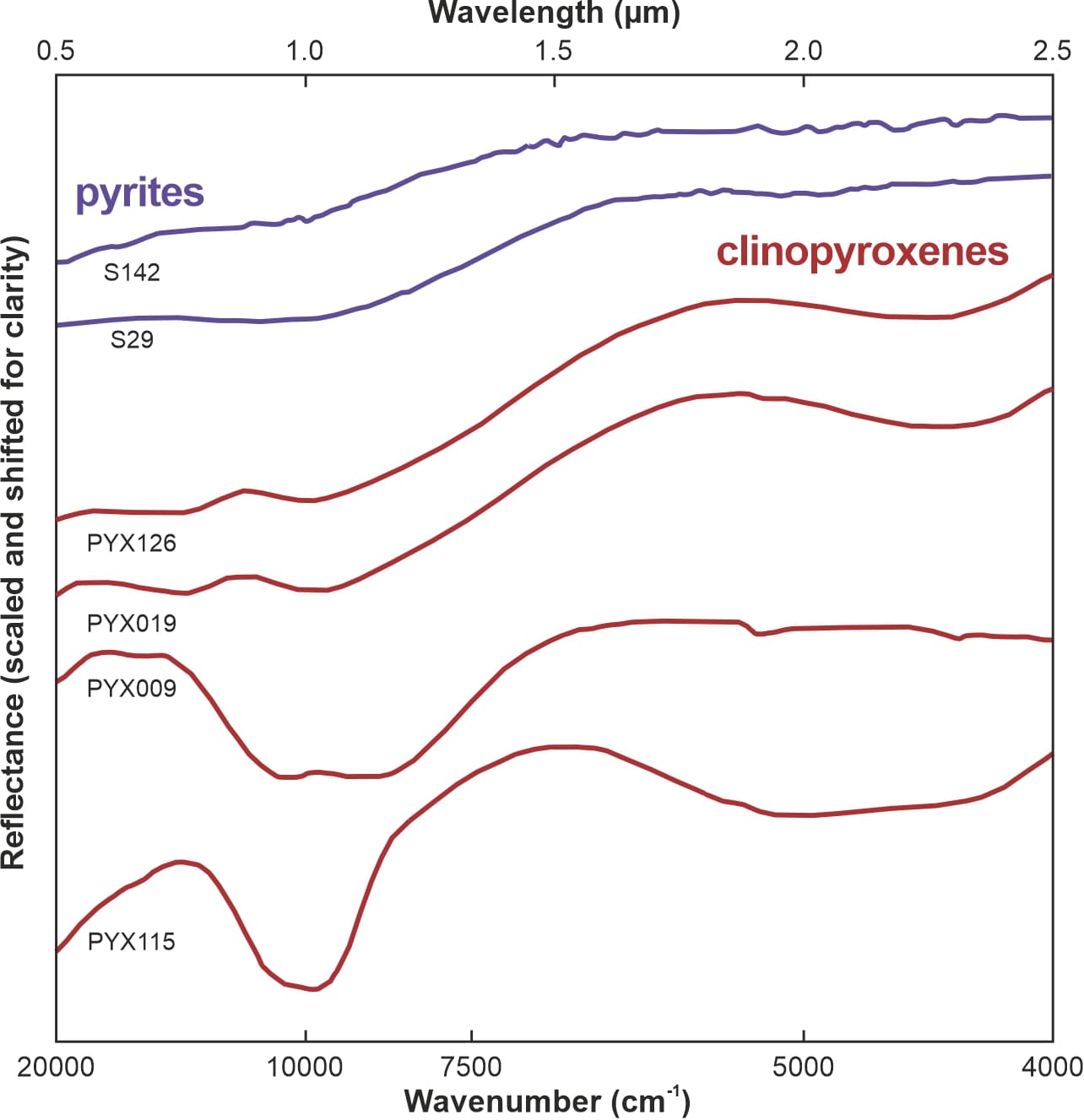
Figure 1. Near-infrared (NIR) spectra of pyrites S142 and S29 compared to those of clinopyroxenes PYX126, PYX019, PYX009, and PYX115, which are all described by Horgan et al. (2014). Note the lack of distinct spectral features in pyrites and their similarity to the NIR spectra of some clinopyroxenes. Considering the low pyrite abundances compared to those of clinopyroxene, pyrite is difficult to observe in the NIR range. The y-axis has no numerical scale as the plots are shifted for clarity.
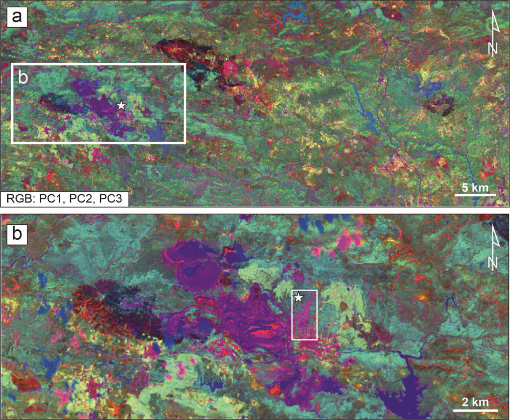
Figure 2. False-color composite, Sentinel-2A PCA (10 m/px) for the study area: PC1, PC2, and PC3 in R, G, and B channels, respectively. PCA image was calculated from the original 9-band (VNIR + SWIR) of Sentinel-2A (bands 1, 9, and 10 were excluded from this analysis as they do not contain mineralogical/geological information). Three first PCA components (PCA1, PCA2, and PCA3), containing the highest topographical and spectral information, are suitable for lithological discrimination, especially for arid region such study area. The pink color indicates areas with high pyrite content. The white frame in panel 'a' marks the region of the Rio Tinto Mining area in Spain. The white frame with the star in panel 'b' shows our study area for geological mapping (see Ciazela J. et al., this session).
How to cite: Ciążela, M., Ciążela, J., Pieterek, B., Mancini, F., Marciniak, D., and Gomez, F.: Towards prospecting ore deposits on Mars: remote sensing of the planetary field analogue in the Rio Tinto mining area, Spain, Europlanet Science Congress 2022, Granada, Spain, 18–23 Sep 2022, EPSC2022-1090, https://doi.org/10.5194/epsc2022-1090, 2022.
Sulfides are the most important group of ore minerals and are especially crucial for copper, silver, and gold. Despite the lack of direct evidence, sulfide ores are anticipated on Mars (Pirajno and van Kranendonk, 2005; West and Clarke, 2010). Rover and orbiter data along with geochemical modeling suggest the presence of pyrite (FeS2), marcasite (FeS2), and pyrrhotite (Fe1−xS) at the Martian surface (Ehlmann and Edwards, 2014). In addition, Martian meteorites show that the Martian crust is significantly enriched in chalcophile elements compared to the Martian mantle (Wang and Becker, 2017) and host a variety of magmatic and hydrothermal sulfides similar to that on Earth (Baumgartner et al., 2017; Lorand et al., 2018).
Infrared spectrometers orbiting Mars with high capabilities to use in mineralogical studies include CRISM (Compact Reconnaissance Imaging Spectrometer for Mars) operating in a wavelength range of 0.4–3.9 µm onboard Mars Reconnaissance Orbiter (MRO), OMEGA (Observatoire pour la Minéralogie, l’Eau, les Glaces et l’Activité; 0.4–5.1 µm) and PFS (Planetary Fourier Spectrometer; 1.3–45.0 µm) onboard Mars Express (MEX). To date, however, few works were able to localize sulfides from the orbit due to difficult interpretation caused by spectral interferences with common silicates, which are impossible to resolve without ground calibration (Horgan et al., 2014). To overcome this, we have mapped for pyrite content a 500 m x 100 m test field rich in pyrite within the Rio Tinto planetary field analog mining area in Spain for pyrite to compare the obtained results with remote sensing data from the Landsat 8, Sentinel-2, and ASTER satellites (see Ciazela M. et al. this session). The Rio Tinto area hosts the largest known volcanogenic massive sulfide deposits on Earth (Martin-Izard et al., 2015).
We have investigated 614 sites along a river bed (Fig. 1) located 3 m from each other. At each site, we investigated 5 random samples for pyrite content. The pyrite content was always estimated by 2 to 4 researchers, and the average for each site was computed. The average pyrite content in the entire investigated area is 7.0 vol.% (12.6 wt.%). We have observed two fields, 30 x 30 m, and 30 x 60 m, with average pyrite contents >50 wt.%, which should be suitable for its detection from the orbit, both with Sentinel-2 (field resolution of 10 m) and Landsat (30 m) (see Ciazela M. et al., this session).
Our results will help determine abundance thresholds for the detection of pyrite on Mars and identify its key spectral features for this detection.
Acknowledgments: This research is supported by the National Science Centre of Poland project OPUS19 no. 2020/37/B/ST10/01420 and Europlanet2024-research infrastructure grant no. 20-EPN2-020.
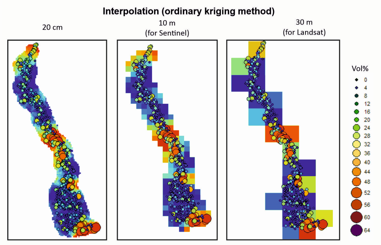
Figure 1. The ordinary kriging interpolation maps of pyrite content based on 614 sampling sites.
References:
Baumgartner R. J., Fiorentini M. L., Lorand J. P., Baratoux D., Zaccarini F., Ferrière L., Prašek M. K. and Sener K. (2017) The role of sulfides in the fractionation of highly siderophile and chalcophile elements during the formation of martian shergottite meteorites. Geochim. Cosmochim. Acta 210, 1–24.
Ehlmann B. L. and Edwards C. S. (2014) Mineralogy of the Martian Surface. Annu. Rev. Earth Planet. Sci., 291–315.
Horgan B. H. N., Cloutis E. A., Mann P. and Bell J. F. (2014) Near-infrared spectra of ferrous mineral mixtures and methods for their identification in planetary surface spectra. Icarus 234, 132–154.
Lorand J. P., Pont S., Chevrier V., Luguet A., Zanda B. and Hewins R. (2018) Petrogenesis of martian sulfides in the Chassigny meteorite. Am. Mineral. 103, 872–885.
Martin-Izard A., Arias D., Arias M., Gumiel P., Sanderson D. J., Castañon C., Lavandeira A. and Sanchez J. (2015) A new 3D geological model and interpretation of structural evolution of the world-class Rio Tinto VMS deposit, Iberian Pyrite Belt (Spain). Ore Geol. Rev. 71, 457–476.
Pirajno F. and van Kranendonk M. J. (2005) Review of hydrothermal processes and systems on Earth and implications for Martian analogues. Aust. J. Earth Sci. 52, 329–351.
Wang Z. and Becker H. (2017) Chalcophile elements in Martian meteorites indicate low sulfur content in the Martian interior and a volatile element-depleted late veneer. Earth Planet. Sci. Lett. 463, 56–68.
West M. D. and Clarke J. D. A. (2010) Potential martian mineral resources: Mechanisms and terrestrial analogues. Planet. Space Sci. 58, 574–582.
How to cite: Ciążela, J., Marciniak, D., Ciążela, M., Gomez, F., and Pieterek, B.: Towards prospecting ore deposits on Mars: geological mapping of the planetary field analog in the Rio Tinto mining area, Spain, Europlanet Science Congress 2022, Granada, Spain, 18–23 Sep 2022, EPSC2022-1119, https://doi.org/10.5194/epsc2022-1119, 2022.
Introduction
The volcanic settings of the Eolian Islands, Italy, offer access to various types of volcanic terrains, with diverse morphology and mineralogy. This study focuses on Vulcano, whose last eruption is dated to 1890 but still shows volcanic activity [1]. The dry landscape and easy access to layers of older and more recent volcanic material, in addition to the possibility of investigating secondary minerals, make this site a very promising analog for our neighbor planets; Mars and Venus. Building on previous expeditions, we have acquired experience and knowledge about the potential of these analog environments and their habitability [2 - 4]. Our objectives for the June 2022 field campaign are: to investigate the surface roughness and active surface processes, as well as spectral characterization of volcanic material (Venus analog) and secondary minerals (Mars analog) with both field and lab instruments (detailed hereafter). We are also interested in the astrobiological aspects of these environments, which could represent early Venus/Mars, pertaining to the questions of life detection, using spectroscopy techniques, and habitability, looking at microbial colonization.
In-situ Instrumentation
Field measurements are collected with the following portable instrumentation:
- VEM (Venus Emissivity Mapper) Field Prototype - simulating the VEM and VenSpec-M instruments that will fly on the next VERITAS NASA and EnVision ESA missions to Venus, respectively [5]. The prototype is composed of a commercial camera and optics with narrow filters at 850, 910, 990 and 1000 nm, corresponding to four spectral windows in the Venus atmosphere where it is possible to obtain mapping of Venus’ surface features.
- Portable Raman - the RaPort handheld Raman instrument by EnSpectr equipped with a 532 nm excitation laser (same wavelength as used for the ExoMars rover) operating at <60 mW laser power, has a spectral range of 120 - 4000 cm-1 (> 2.5µm) at 6-9 cm-1 spectral resolution and a spot size of around 0.5 mm.
- Portable XRD/XRF Terra - is a portable X-ray diffraction/ X-ray Fluorescence instrument born from the need to perform XRD analysis on the Mars Science Laboratory (MSL) and is being now widely applied for Earth on field applications.
- Mini-PAM - instrument used to detect the presence of chlorophyll and photosynthetic activity.
- Portable spectro-radiometer (PSR+3500) operating in the visible and near-infrared spectral range (350 – 2500 nm) with a spectral resolution between 3 and 8 nm and a measurement spot size of 3 by 3 mm and is best used for mineralogical investigations.
- The Integrated Positioning System (IPS, developed at DLR) combines stereo camera, inertial and GNSS measurements for localization, 3D reconstruction and inspections in unknown environments. Equipped with a thermal imaging camera (Optris PI 640, spectral range of 8 - 14 µm), the hand-held prototype is investigated for exploration and thermal mapping of fumarolic fields [6].
Laboratory analysis
Further measurements on collected samples from Vulcano are performed at the Department of Planetary Laboratories (PLL)[7] at the German Aerospace Center (DLR, Berlin, Germany) in the:
- Planetary Spectroscopy Laboratory (PSL) - by mean of three Bruker Vertex80V FTIR spectrometers at PSL we can measure bi-directional bulk sample spectroscopy of the collected samples completely under vacuum in the whole spectral range from UV to FIR (0.25 µm to at least 25 µm spectral range). A Bruker Hyperion 2000 FT-IR microscope allows mapping smaller grains from VIS to MIR (0.4 to at least 16 µm spectral range) with a spatial resolution down to 50 µm.
- Raman-Mineral- Biology Detection Lab (RMBD) - equipped with a confocal WITec alpha 300 system, a piezo-driven scan table, a UHTS 300 spectrometer with an ultrafast EMCCD detector and a frequency-doubled Nd:YAG laser at 532 nm excitation wavelength. The spot diameter at the sample is ~2.5 µm and the spectral resolution of the spectrometer 4–5 cm-1 at 600 l/mm grating.
- Planetary Analog Simulation LABoratory (PASLAB) and Mars Simulation Facility-Laboratory (MSF) - selected samples are further tested in our simulation facilities able to recreate Mars and other planetary environmental conditions by a controlled gas mixing system (up to 5 gasses, e.g. CO2/N2/Ar/CH4/O2) with H2O, a resulting pressure of 6 – 10 mbar (Mars) and up to 1 bar (Earth-like conditions) and diurnal cycles of radiation (190 nm – 2200 nm), humidity (rh % 0 to 100) and temperature (-70°C to 130°C).
Discussion
This is the sixth time a field campaign coupled to a summer school takes place on Vulcano. It is a remarkable site to test and train instruments, rovers, or data processing techniques of high interest for planetary science (for instance, testing the potential of portable LIBS and VIS/NIR spectrometers [2-4] or mapping using drone and camera data [8]). The comparison between field and laboratory measurements, as well as with data acquired from previous field campaigns to the same site, provides useful hints on the further understanding and characterization of these terrestrial sites as planetary analogs. Moreover, it plays an important role in enhancing the capabilities of these in-situ techniques for the characterization of extraterrestrial environments in the view of the analysis and interpretation of orbital and in-situ planetary data. In terms of habitability and the search for life, the identified extreme and unique environments present at Vulcano inform us on strategies and protocols on how to detect life elsewhere.
Acknowledgements
The Vulcano Summer School is provided limited support by the ARCHES Project (Helmholtz Association Project Alliance ZT-0033) and institutional support from various universities and research institutions such as DLR, Jacobs University and University Freiberg.
References
[1] De Astis G. et al. (2013). Geol. Soc. Lond. Mem. 37 (1), 281 LP – 349.
[2] Rammelkamp, K. et al. (2021).. Spectr. Acta Part B: Atomic Spectroscopy, 177, 106067.
[3] Stephan et al. (2019), EPSC Abstracts Vol. 13, EPSC-DPS2019-2062, 2019.
[4] Stephan, K. et al. (2020), LPSC2020, p. 2411.
[5] Helbert et al. (2020), EPSC 2020, EPSC2020-260, https://doi.org/10.5194/epsc2020-260.
[6] Irmisch, P. et al. (2021), Geometry and Vision. ISGV 2021, vol 1386, pp 68–84.
[7] Helbert et al. (2022), 53rd Lun. and Planet. Sci. Conf., Co #2678, id. 1850.
[8] Gwinner, K. et al. (2000), Eos 81, 44, pp. 513, 516, 520.
How to cite: Baqué, M., Alemanno, G., Adeli, S., Bonato, E., D'Amore, M., Garland, S., Gwinner, K., Herrmann, C., Helbert, J., Irmisch, P., Maturilli, A., Pisello, A., Sohl, F., Stephan, K., Thomson, L., and Unnithan, V.: Vulcano (Italy) lava fields as Mars and Venus analogs: field and laboratory characterization, Europlanet Science Congress 2022, Granada, Spain, 18–23 Sep 2022, EPSC2022-1151, https://doi.org/10.5194/epsc2022-1151, 2022.
The Makgadikgadi Basin in Botswana hosts a system of salt lakes, which developed from the Upper Pleistocene onwards due to gradual shrinking of the giant Lake Palaeo-Makgadikgadi in the last 2 million years. This lake, in the central Kalahari is the key to understand the climatic variability in southern Africa in the Quaternary and holds important role for the evolution of numerous taxa. Stratigraphic and palaeoclimatic studies of this area are complicated by the influence of several factors, such as a complex history of regional tectonic activities, as well as climatic changes coupled with dryland diagenetic processes. In the Makgadikgadi Pans, in fact, there is an overlap of processes linked to groundwater upwelling, seasonal flooding and dry climate pedogenesis (including formation of calcretes and silcretes), all shaped by an intense aeolian activity.
It is the overlap of these morphological and geological factors that create a unique terrestrial analogue for the exploration of Mars where scientists can study adaptation strategies of extremophiles, diagenesis of biomarker, but also test sensors that were built to study the atmosphere of Mars and need calibration under certain environmental conditions.
Here we introduce the new frontiers of research conducted in the Makgadikgadi Pans and we provide a new background on the geology of the basin and the evolution of the sedimentary system in the Makgadikgadi. In particular, we provide detailed sedimentological analyses of the shallow sub-surface of the Makgadikgadi Pans combining physical and geochemical properties of the pan sediments with the first comprehensive study of paleontological proxies (ostracods) in order to establish trends in the environmental changes in the area from the Late Quaternary.
The research activities of the last few years in the Makgadikgadi Pans provided new benchmarking data that will not only shed light on one of the largest evaporitic basins in the world but also support further investigations in the field of planetary sciences and astrobiology.
How to cite: Franchi, F. and Lebogang, L.: From dust devils to lipid biomarkers: a planetary perspective of the Makgadikgadi Pans, Central Botswana, Europlanet Science Congress 2022, Granada, Spain, 18–23 Sep 2022, EPSC2022-84, https://doi.org/10.5194/epsc2022-84, 2022.
Having knowledge in geology and more particularly in impact geology is, and will be, a necessity toward exploring, and what is more, toward exploiting the surface of nearby planetary objects (Moon, Mars and asteroids), as impact cratering is the major active geological process at work on these surfaces. Sooner or later astronauts will walk on these surfaces and will have to be able to characterize the terrain. They will do Geology. This will require specific training. If, as happens during education, a part can be "masterful", training in geology requires a minimum of experience on the ground, in order to recognize the rocks from the outcrops, in order to follow and map contacts between different lithologies, structures, in order locate oneself in space, to collect sample and to carry out various field measurements. Today, and in the future, after manned flights to the Moon will have been re-established, the Earth is and will remain the best candidate to provide this field training. Ditto for developments and testing field instruments and tools specific to geological studies on the Moon or other planetary surfaces, whether these tools are used by men or by robots. This leads to the use terrestrial analogues, especially impact sites. The purpose of this presentation is to assess how terrestrial impacts in general and Rochechouart in particular, may contribute to this objective. To this end, a large part of the presentation will be devoted to the discussion of the criteria and qualities required, and to a review of the terrestrial impacts which already participate into such efforts or which would be useful to participate (see also [2-4]).
We will retain among the criteria, the geological interest (nature, significance, diversity, quality of the rock exposures), and the practical aspects (geographical accessibility, the risks (political, health, etc.), the distance between outcrops of interest, the availability of dedicated support on site (infrastructure and skills).
Obviously, no impact crater on Earth or on another planet, can expose all the direct and indirect features associated with impacts, such as distal effects, ejecta, the various impact deposits in the crater and the wide variety of damage and manifestations observed, at the scale of the outcrop, under and on the periphery of the large impact craters (autochthonous breccias, mega-blocks, fractures, pseudotachylitic breccias, shatter cones, ultra-cataclasites, hydrothermal deposits, etc…).
Rochechouart will receive particular attention because, in addition to its geographical accessibility, it is distinguished by the diversity and richness of the impact geology exposed. Its level of erosion oscillates on either side of the crater floor, offering the geologist an unparalleled set of natural sections, both in the crater infill and into the target underneath the crater. In other terrestrial impact structures, only part of the typical impact facies is usually represented, and usually either in the crater or below it. All the facies are represented at Rochechouart, both in the crater, including the impactoclastites, and below, including the hydrothermal-type post-impact effects, which may be of economic and/or biological interest in relation to the effects of impacts on the habitability of planetary surfaces and on the emergence of Life [5]. Rochechouart allows the geologist to see and to follow the limit between the rocks filling the crater and the rocks of the target beneath, i.e., it allows to study the bottom limit of the transient cavity produced in a large, deca-kilometer impact crater. The richness of the field at Rochechouart is reinforced by the installation and availability to the geologist of the CIRIR “Impact on Shelves” facility, a large sample library that is unique in its principle and its destination [6].
Developing a field training offer for astronauts and future planetary geologists will be open to discussion.
References: [1] Phinney W. C., (2015), NASA SP-2015-626, 318 p., [2] Kring D., (2010), Nordlingen Ries Crater Workshop, LPI Contribution 1559, 7036.pdf, , [3] Mangold et al. (2022), ICF-CIRIR 2022, Kring D. A. et al., (2020), LPI Contribution No. 2576, [4] Osinski G. R., 2022, 53rd LPSC, [5] Brack A. et al. (2022), ICF-CIRIR 2022, [6] Lambert P. (2019), LMI 6th, Brasilia, USRA 5027.pdf
Acknowledgements: Thanks to Jean Pierre Lebreton, Uwe Reimold and Frances Westall for help with the preparation of this abstract. Special thanks to the local territories (“Porte Océane du Limousin” and “Charente Limousine”) for support, and special thanks to all the members of the CIRIR consortium (list at cirir-edu.org) without whom all the research and foreseen development at Rochechouart and at other terrestrial impact sites would not be possible.
How to cite: Lambert, P.: Terrestrial impact sites for field training of Astronauts and future "Field Planetary Geologists", Europlanet Science Congress 2022, Granada, Spain, 18–23 Sep 2022, EPSC2022-292, https://doi.org/10.5194/epsc2022-292, 2022.
After a pause of two years, the two-week summer school at Vulcano, Sicily in June 2022 brought together, once again, scientists, researchers, students, and technicians, to another field campaign dealing with topics ranging from geology to robotic environmental exploration, astrobiology, and the study of planetary analogues. A number of successful (planned and unplanned) experiments and sampling campaigns were carried out on the island and in the coastal waters around Vulcano.
Vulcano is the third largest and southernmost island of the Aeolian archipelago in the Tyrrhenian Sea. The central Fossa crater on Vulcano has similar surface morphology to lunar and martian regions with extremely dry, arid conditions, little or no vegetation cover, angular grains over a range of grain-sizes. The diverse and extreme (hostile) environments at Vulcano provide an essential training ground for testing instruments and techniques foreseen for future robotic exploration missions to Mars and other bodies with a particular focus on astrobiology. This year, as in the past campaigns, a variety of spectral instruments ranging from visible and near-infrared (VNIR) reflectance to Raman spectroscopy will be deployed at various sites for mineralogical, biological, and elemental analysis. The in-situ survey, and its comparison with laboratory standards and instruments, will provide an assessment of the usability of these techniques to characterize extraterrestrial environments and guide our search for life in the Solar System (e.g. via assessing the detectability of biosignatures).
Drone photogrammetry surveys provide the regional context, map areas of interest such as potential hazards, while an Integrated Positioning System (IPS) in combination with infrared thermal imagery was deployed for future mapping and thermal stability analysis of different sites on Vulcano.
Furthermore, geophysics techniques such TEM and IP electric measurements of fumaroles and their 3D structure will be investigated. Last but not least, robotic missions for terrain analysis, locomotion and mapping will be undertaken on various lunar and martian analog terrains.
How to cite: Unnithan, V. and the VulcanoTeam2022: Vulcano Summer School 2022: Overview of the field-based terrestrial, marine and planetary analogue studies campaign, Europlanet Science Congress 2022, Granada, Spain, 18–23 Sep 2022, EPSC2022-1109, https://doi.org/10.5194/epsc2022-1109, 2022.
AMADEE-20 is the latest Mars Analog Mission of the Austrian Space Forum (OeWF), conducted in Israel in the Negev Desert and hosted by the Israel Space Agency.

The 40 km long and 11 km wide Ramon Crater is an erosive crater unveiling a geological window of different sedimentary and volcanic processes with formations of sandstone, shales at the crater base, and mostly limestone and dolomite by the crater wall and represents sediments of the Thetis paleo-ocean with several volcanic and plutonic episodes including paleo-volcanos and granites. This nascency is accompanied by a semi-arid climate with dry summer (June – September), mild winter (December- February), and sparse vegetation only growing on the high rim hillslope and wadis (dry streams). Therefore, the Ramon Crater (Maktesh Ramon) presents remarkable geologic and geomorphological structures comparable to the Red Planet. Hence, beyond traditional analog mission applications, such as equipment behavior and evolving the know-how on crew management, we had the opportunity to develop research methods to catalyse the visibility of planetary explorations and develop structures for life-detection systematics and geoscientific techniques.
Two main segments of the mission; the mission support center (MSC)- on Earth time- and the field crew- on Mars time- were emulating a planetary surface mission by keeping a 20min time delay (10 min per signal direction) to account for the average signal travel time between Earth and Mars. The MSC was staffed by a Flight Director, Biomedical Engineers, Earth Communicators, CONTACTS,Records Manager, Procedure monitoring, Human Factors, Remote Science Support, Flightplan Team, Ground Support & Security, Science Data Officer, and Media Communication. The field crew was divided into two elements; I) the flight crew (6 AAs) with the analog astronauts, who conducted the experiments, and ii) the on-site support team (12 crew members) who provided support without interfering with the experiments or interacting directly with the AAs. Thereby, also maintaining a secured parameter and safety infrastructure for the simulation All major workflows of the mission were defined via the OeWF Standard Operating Procedures.

The flight crew habitat was provided by the Israel Space Agency and D-Mars, based upon the foldable D-Mars station design, complemented with a new module comprised of a Command module, Engineering/Science compartment, Crew quarters, Storage space, Mess and Hygiene module.
To provide a realistic platform for the experiments, isolation protocols were in place ensured. In total, 25 experiments were conducted from the fields such as engineering and robotics, human-robot interactions, health sciences, life sciences and geosciences. Outcomes of these experiments and the AMADEE-20 mission will be presented. This included an innovative science strategy, the exploration cascade which is an algorithm providing an efficient deployment sequence of scientific investigations (Groemer and Ozdemir, 2020).
In the meantime, the preparations for the 14th analog mission of the OeWF, AMADEE-24 have started. With a comparable mission architecture as described above, we will be soliciting proposals for research experiments, to be selected peer-review process. These missions are a formidable platform for testing technologies, instruments and science workflows as well as it is a research opportunity for human factor studies.

REFERENCES:
Groemer G. and Ozdemir S. 2020. Planetary Analog Field Operations as a Learning Tool. Front. Astron. Space Sci. DOI: https://doi.org/10.3389/fspas.2020.00032
How to cite: Özdemir, S., Grömer, G., and Gruber, S.: Overview of AMADE-20 Mars Analog Mission and Insights from AMADEE-24, Europlanet Science Congress 2022, Granada, Spain, 18–23 Sep 2022, EPSC2022-1247, https://doi.org/10.5194/epsc2022-1247, 2022.
Please decide on your access
Please use the buttons below to download the presentation materials or to visit the external website where the presentation is linked. Regarding the external link, please note that Copernicus Meetings cannot accept any liability for the content and the website you will visit.
Forward to presentation link
You are going to open an external link to the presentation as indicated by the authors. Copernicus Meetings cannot accept any liability for the content and the website you will visit.
We are sorry, but presentations are only available for users who registered for the conference. Thank you.
Please decide on your access
Please use the buttons below to download the presentation materials or to visit the external website where the presentation is linked. Regarding the external link, please note that Copernicus Meetings cannot accept any liability for the content and the website you will visit.
Forward to session asset
You are going to open an external link to the asset as indicated by the session. Copernicus Meetings cannot accept any liability for the content and the website you will visit.
We are sorry, but presentations are only available for users who registered for the conference. Thank you.